Sensational Utah has the largest concentration of National Parks anywhere in America. Featuring The Intentional Traveler’s essential itinerary for a killer Utah driving adventure.

Utah is home to a number of America’s most amazing National Parks. Featuring spectacular scenery, great hiking trails and breathtaking natural formations.

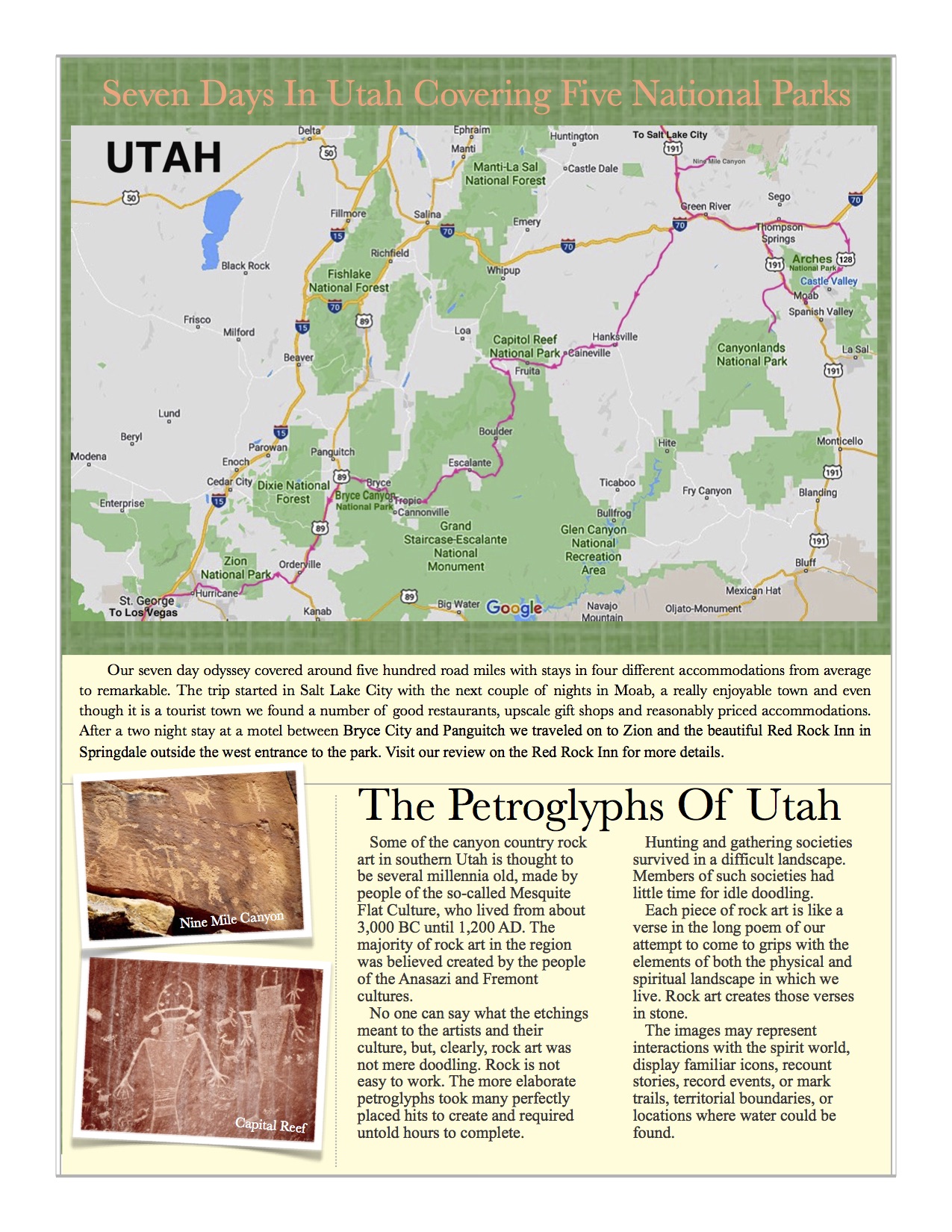
Traveling around the United States, some of the most visited destinations are parks, with the National Parks being by far and away the most popular. The Blue Ridge Parkway is the most visited in America, probably because of its’ location near the Eastern Seaboard. Yellowstone, the Grand Canyon and Yosemite come in second, third and fourth because of the scale, grandeur and spectacle of the scenery. If you’re looking for the most concentrated park experience, consider the state of Utah. After taking a two week driving trip through Utah we decided that if you took away the National Parks, the National Forests and State Parks there wouldn’t be much left of the state.
Traveling about a five hundred mile route starting in Salt Lake City we visited five spectacular National Parks and some additional state parks. This is the order of the parks we visited:

- Arches National Park
- Canyonlands National Park
- Capital Reef National Park
- Bryce Canyon National Park
- Zion National Park
Throwing in a few Utah State Parks along the way we concluded this was one of the most worthwhile road trips we have ever taken.
We started our trip in Salt Lake City which was NNW of Arches National Park and even that first part of the drive was memorable. We ended our adventure in Los Vegas which is about 150 miles SW of Zion National Park. In planning a trip like this you’ll discover that there are a number of lesser known National Parks to also consider like Red Rock Canyon, Tule Springs Fossil Beds, Gold Butte and the Grand Canyon Park Utah sections.

Following is a synopsis of the trip with a few recommendations.
Nine Mile Canyon
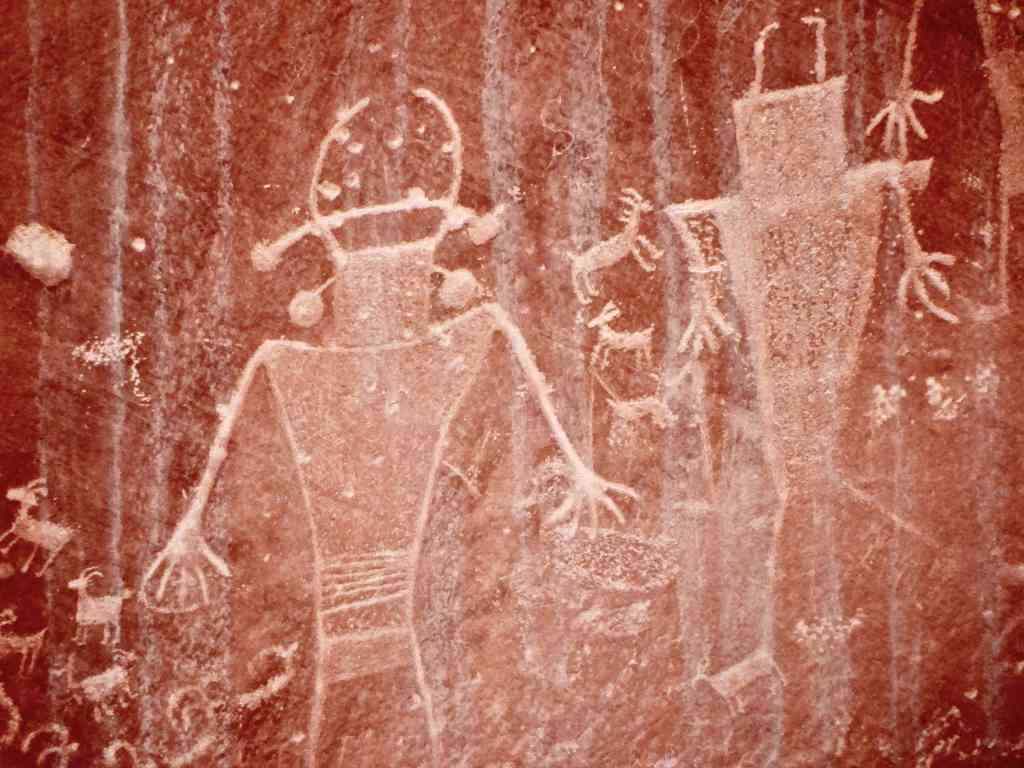
On our way south we took a side trip to Nine Mile Canyon. We had been told about the canyon and had also read an article regarding the locations of petroglyph sites in the area. The canyon is actually forty-eight miles long, not nine, with the first petroglyph site about twenty-seven miles in. Unfortunately we misplaced the article, which listed the location of each site based on your odometer reading at a sign at the start of the canyon. Without that information, once into this isolated area, we realized what a mistake that was. The two-lane road had virtually no traffic (except some free roaming cattle) and there was very little in the way of signage. We passed the first marker twice without seeing it – a small green sign on a post only six inches tall and ten inches wide that simply said “First Site” and an arrow. If you have the time, a visit to a few of these thousand year old sites is really interesting.
Getting into Moab late in the afternoon we checked into the motel and got something to eat with a plan to start in Arches National Park the next day.

Arches National Park
We visited Arches National Park early in the morning and realized that no photograph or description can begin to express the massive size of its’ formations or the scale of the arches and balancing rock towers. This place just has to be experienced to be believed. The sandstone formations are enormous, the colors are fantastic and you feel like a child entering a world of giants. If you are a hiker, there are a large number of very walkable trails in the park, temperature permitting, along with a number of scenic drives. On the subject of weather, it is very important that you carry water in your car and with you if you are hiking. The high temperatures and dry conditions can be punishing and even dangerous.
Canyonlands National Park
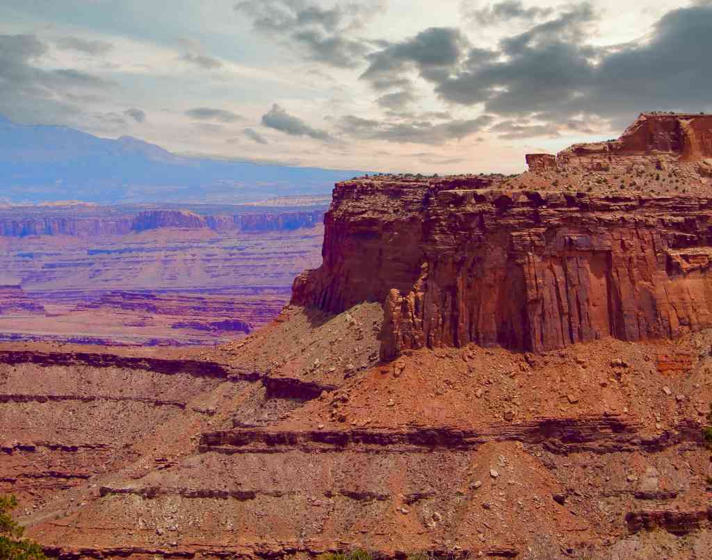
Only about twenty-five miles from Arches is the northern entrance to Canyonlands National Park and it is a wholly different experience as you enter on high bluffs and look down into the canyons. The landscape is similar to the Grand Canyon in character and color as you stand on the rim. In the western area of the park are the best hiking trails where an extinct volcano caldera formed an interesting bowl-like valley. There is also a second entrance to Canyonlands about sixty miles south of Moab that features the Needles District with a strikingly different look, featuring backbone formations of rows of sandstone spires.
Dead Horse Canyon
Between Canyonlands and Arches is a state park named Dead Horse Canyon which is worth a visit as well. Stand at Dead Horse Point, 2,000 feet above a turn in the Colorado River, and amaze at the ever-changing landscape below. Immense vertical cliffs climb up from canyons carved by ions of weather creating this masterpiece.
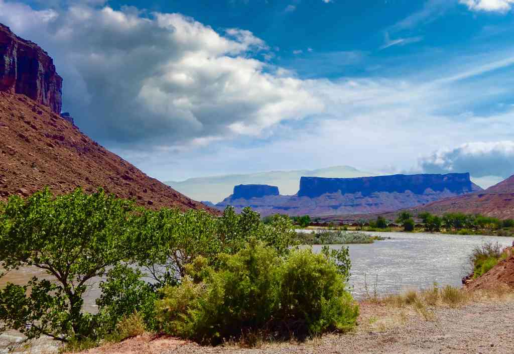
Scenic Route 128
Just south of Arches National Park take a free drive along scenic Route 128 North as it runs up another canyon of the Colorado River. As you follow the river, you are surrounded by 500 to 1,000 foot rust colored sandstone cliffs with many completely vertical. On the river you see numerous rafting groups and as you drive deeper into the canyon the land opens up revealing dozens of spires and buttes.
In the canyon is a small town named Castle Valley and on the river is the Red Cliffs Lodge and the Castle Creek Winery. The winery offers tastings and features some good wines that are popular in the region’s restaurants.
On the map you may notice a ghost town named Cisco and might be tempted to go take a look. Do not bother – the town is a junkyard of abandoned trailer homes and RVs laced with obscene graffiti. Our suggestion is when you reach Dewey Bridge, turn around and drive back unless you are going on to US 70. While we didn’t visit, we were told that there is an interesting movie museum near the Castle Creek Winery and there are numerous raft operators that will take you down this stretch of the Colorado River.

Capital Reef National Park
Leaving Moab the next morning we headed north on 191 to US70 west. We exited 70 onto Route 24 south and headed to Capital Reef National Park. Capital Reef is home to another collection of petroglyphs and these are well marked with easy access from the road. This is also the location of Fruita which was established by Mormons as an agricultural area in 1880. A few structures from the original settlement still remain as do the orchards.
Route 24 travels right through Capital Reef with one scenic side road inside the park featuring a number of good hiking trails. After exiting Capital Reef on 24 west we picked up Route 12 heading south towards Bryce Canyon National Park.
Driving The Hogs Back (Utah Hwy 12)
Leaving Capital Reef National Park going west on St. Rt. 24 you meet an intersection with St. Rt. 12. 24 goes north at the T while 12 heads south. Our GPS and our trip map both indicated we should turn north on 24 toward the interstate. Looking at the map it seemed a much shorter trip taking 12 to the left. Utah Route 12 is a scenic and interesting trip from Capital Reef to Bryce Canyon. It crosses some spectacular country with ridges, canyons and mountains at every turn. One stretch, called the Hogs Back, navigated a ridge with only two narrow lanes and steep drops on both sides. It is, without a doubt, the scariest piece of road we’ve ever driven in good weather. (See our article on the Hogs Back.)
Anasazi State Park
Another unexpected find was the Anasazi State Park on St. Rt. 12, shortly before getting to the Hogs Back. It is an archaeological site of an Anasazi Indian village excavation with a trail through the site and a nice museum displaying artifacts.
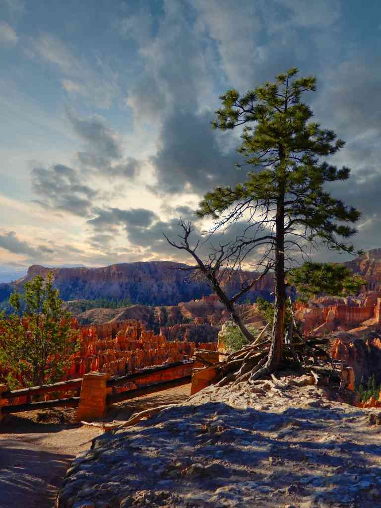
Bryce Canyon National Park
Bryce Canyon is a must visit. The park sits atop high country, looking down into the canyons which are packed with geological features called hoodoos. There are interconnected spires of colorful sandstone creating mazes that rise from the canyon floor and hiking trails down into the hoodoos. While hoodoos are not unique to this site, nowhere in the world are they as abundant as in the northern section of Bryce Canyon. Many of the hiking trails are steep, going down the canyon face, descending an average of 700 feet but, there are also a few walkways, for those seeking less of a challenge.
There is a hotel with a restaurant inside the park but there are also a number of accommodations just a short drive away starting at Bryce Canyon City. The Park Service, in an effort to reduce traffic, operates free buses with pick-up stops in the “City”. The drive through the park is about nineteen miles to the end at Rainbow Point with an altitude of nine-thousand feet. At the point, the morning we were there, the winds were howling and the temperature dropped over twenty degrees after leaving the Visitors Center.


Red Canyon is between Bryce Canyon and Panguitch where we spent two nights. Our motel had a colony of resident prairie dogs that liked to come out and socialize around dusk and the second night we were visited by a pronghorn antelope. The canyon road goes through two short tunnels cut through sandstone with a couple of parking areas for access to some interesting hiking trails. One cautionary note here is that Panguitch is mostly closed on Sundays and it can be a challenge finding a place to eat.
Zion National Park

After two nights near Bryce Canyon in Panguitch we headed off early for Zion. We had read that Zion has a traffic problem and that by late morning parking is almost impossible to find. Like Bryce Canyon, Zion also has a free shuttle bus that picks up at stops in Springdale, the town just outside the southern entrance to the park. In season Zion Canyon Scenic Drive is only open to the park’s buses, which can be picked up at the Visitors Center near the south entrance. Of the parks we visited, Zion had the largest number of hiking trails ranging from wheel chair accessible to strenuous. One of the park’s more popular hikes goes through “the narrows” which is a narrow width passage through a sandstone canyon with a stream flowing through it . Unfortunately, this trail and a few others require a permit and there is usually a wait of several days to get one.
Driving down from Panguitch we entered Zion around 9:00 am at the east entrance. There were maybe three or four cars ahead of us and we traveled down canyon walls through numerous switchbacks and two tunnels. One two lane tunnel was almost a mile long with no lights, so it is important to test your headlights before entering. We got to the Visitors Center around 10:00 and had to search for parking. We took a couple of hikes on trails near the Visitors Center and by noon the line for the tour buses wound through the complex and out into the parking lot requiring a wait of over an hour. A few hours later when we exited to the town of Springdale the line of cars to get into the park was backed up over a mile through town.

We spent the night at The Red Rock Inn and it was the highlight of the trip’s accommodations. Located in town and a couple of miles from the park it was comfortable, beautifully decorated and clean. The owners were helpful and friendly and the room came with a voucher for breakfast at Oscars, a block away. Oscars was also great, offering a full breakfast and plenty of coffee. The whole town is nestled in a canyon with towering red sandstone cliffs above it and unbelievable traffic “in season.”
The next morning we headed for Los Vegas for a couple of nights on the strip and our flight home. During the trip we saw snow (Panguitch averages six inches in June), windy conditions and virtually no rain. In summary, it was a road trip of a lifetime offering spectacular scenery and temperatures ranging from freezing to over one hundred degrees.I think we will make a return visit someday…

Links To Additional Information On The Parks Of Utah
Spectacular vistas greet you at every turn as you travel through the parks of breathtaking Utah. A road trip is the best way to experience this place so get packing…
