
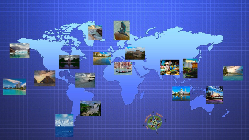
The Intentional Travelers map collection
We love maps and have created a collection of modified maps to help navigate as we travel. We hope you’ll take advantage of our creations.
- Hiking Trails & Urban Walks
- Metro Systems And Public Transportation
- Maps For Getting Around Featured Locations
THESE MAPS ARE FREE AND SAFE TO DOWNLOAD. CLICK ON ANY MAP TO DOWNLOAD THE PDF FILE.
Vancouver’s SkyTrain Metro. Great town with really good public transportation. Get from the international airport to Canada Place cruise terminal faster than a taxi for just a few dollars.

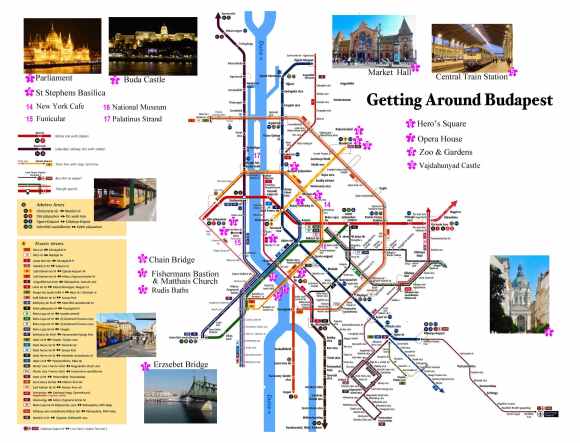
Seeing Budapest using public transportation – Budapest is a wonderful city with a remarkable public transportation system. Modern light rail and subways can take you all around the city.
Paris Metro – a simplified guide – The Paris Metro is world renowned and here we offer a simplified system map focused on the main tourist destinations.


The Trains of Metro Rome Rome is a large metropolitan area with commuter trains servicing the international airport, the historic center and the seaport of Civitavecchia. Using public transportation can save time and money.
Singapore Metro Map – Inexpensive, incredibly clean and efficient this city’s metro is one of the best in the world.

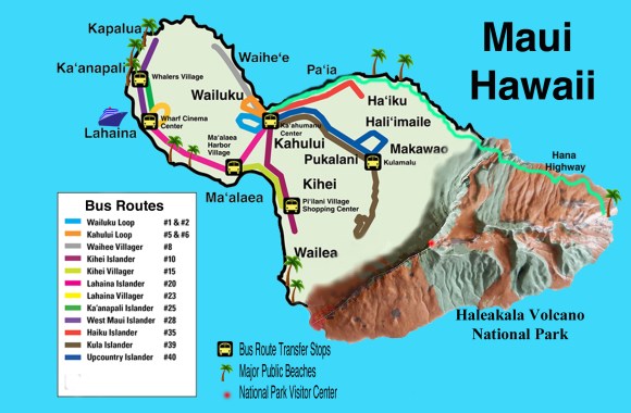
Bus routes on Maui, Hawaii – This island has an incredible public bus system that will take you around the whole island except up through the National Park.
Disney World Transportation Systems– Larger than New York’s Manhattan the Disney people have provided an efficient system to get you around that includes buses, boats, monorails and cable cars.
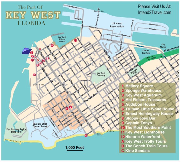
Key West Florida is an American original – Easy to get around on foot the heart of this town is a joy to explore.
Tourist Guide to Singapore bus routes – In addition to the Metro there is a modern fleet of mostly double-decker buses that can take you around the central city, along the coastal Marine Parade area to the airport

Public transportation Sydney Australia – A fantastic, modern city with a great public transportation system that includes regional trains, light rail and a fleet of ferries.
The Trails of Iguazu Falls Argentina This park has over 30 miles of trails and it’s important to know which ones are the most spectacular to get the most from your visit.

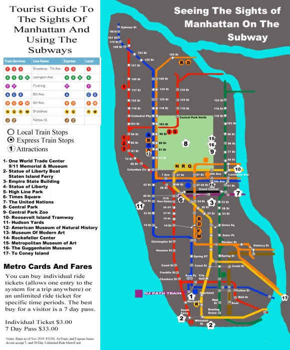
The New York subways are a fast way to see Manhattan and this map eliminates everything but the Manhattan stops and the locations of major sites and attractions.
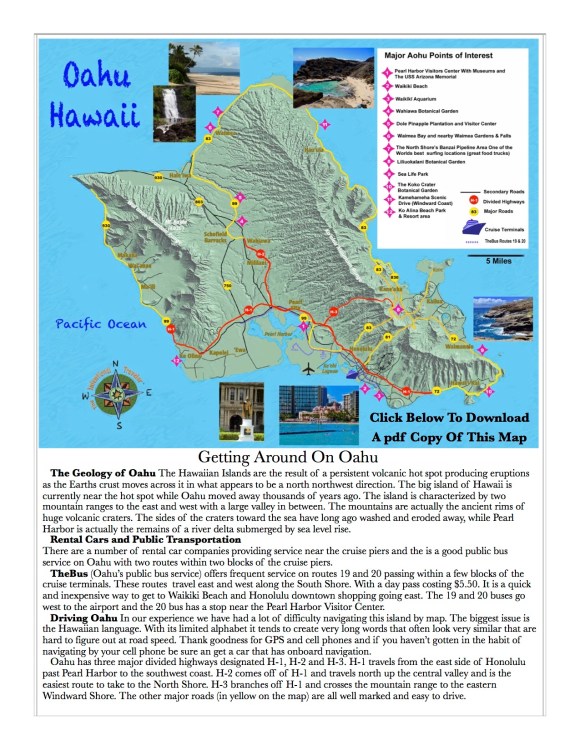
Driving Oahu and the attractions – Oahu is an island where you need to drive. There are a couple of bus routes that service Honolulu and the Pearl Harbor area that are convenient if you are visiting on a cruise ship or staying near Honolulu.

Yellowstone National Park is the size of the state of Delaware and you should need a plan before you get there. Here are 5 major attractions along with driving routes.
- Midway Geyser Basin
- Old Faithful
- Mammoth Hot Springs
- Yellowstone Grand Canyon
- Upper Geyser Basin
Utah Driving Tour – Utah has the countries largest collection of National Parks along with some great state parks. Visit the article HERE.

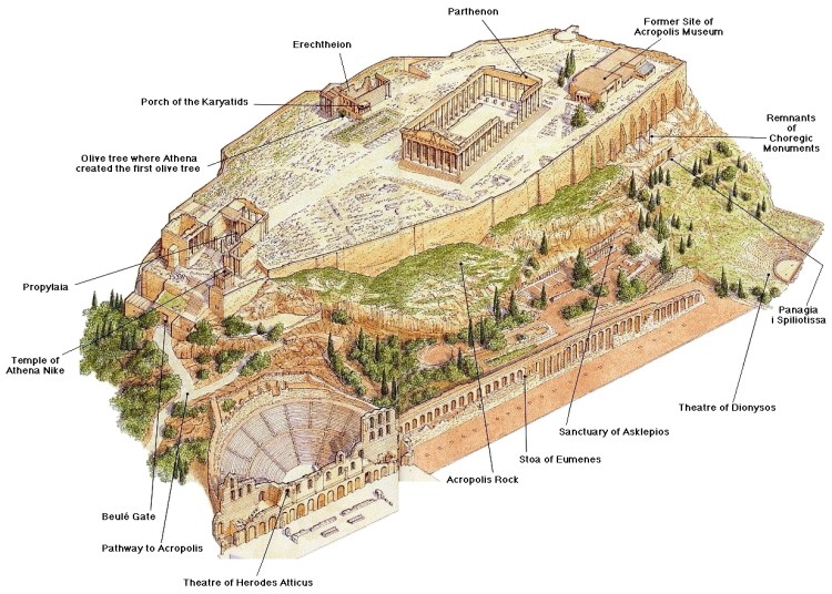
The Acropolis in Athens – A 3D map providing an interesting perspective of the ancient Acropolis and the historic surrounding area.
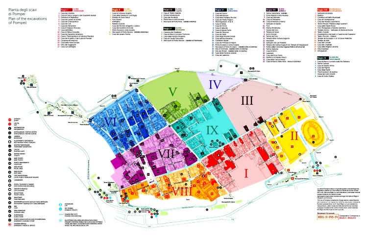
Pompeii, Italy – A visitors map to the archeological site of the 2,000 year old Roman city of Pompeii.

The Forum in Rome – A 3D map of the ancient Roman Forum.
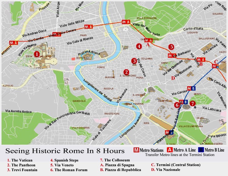
One day tour of Rome – A guide to hitting the major sites of Rome in just 8 hours on your own.
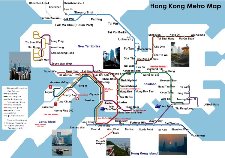
The Hong Kong Metro – A world class metro system that’s inexpensive, clean and covers most of the region.
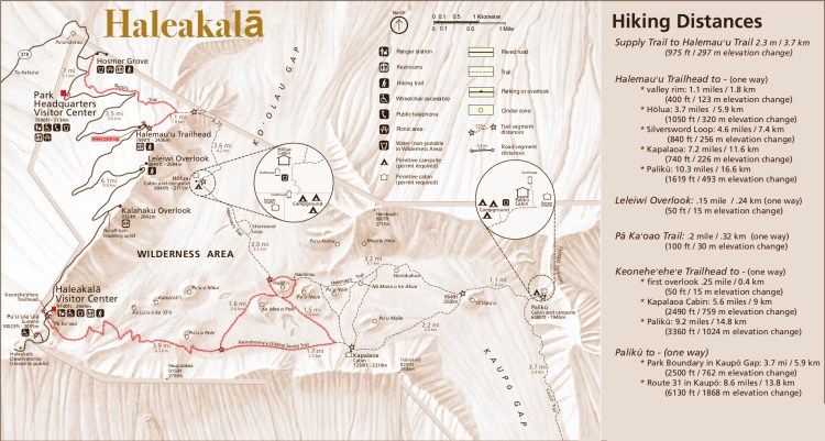
Hiking Haleakalā National Park – Hiking trails on Maui’s great volcano.
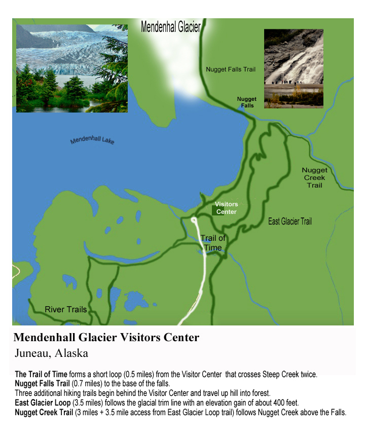
Mendenhall Glacier – Hiking trails around the glacier and the glacial lake in the National Park outside Juneau Alaska.
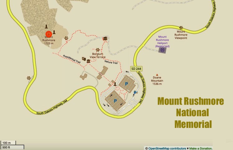
Mount Rushmore National Monument – Great hiking trails around this unique national monument.

Florence, Italy – A great city for exploring on foot. This map features several walking tour routes in the fantastic city.
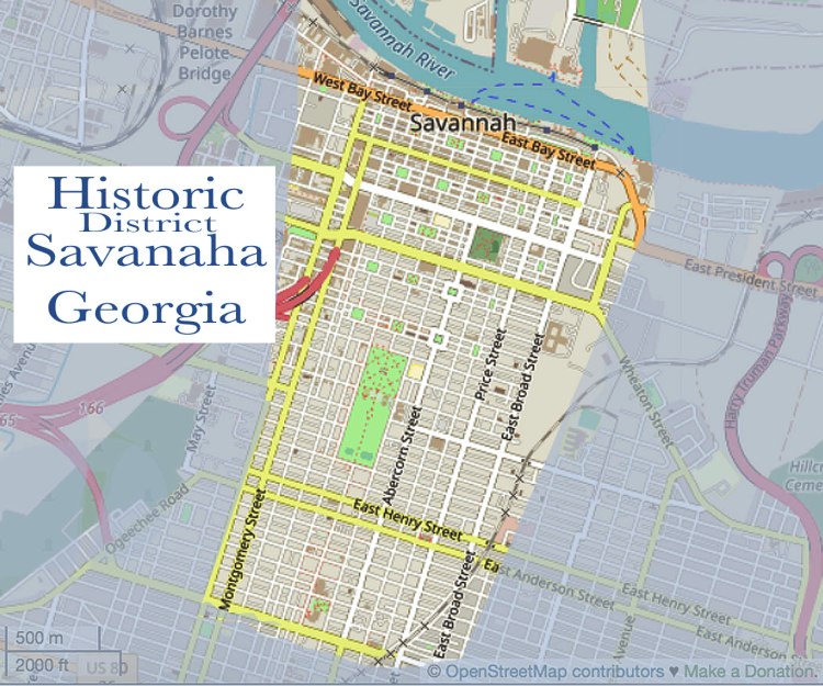
Savannah, Georgia – The grand old lady of the South, this is a beautifully laid out city, easy to walk with great sights.
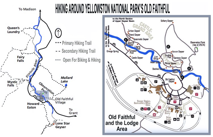
Hiking near Old Faithful in Yellowstone – trails through the largest concentration of geo-thermal geysers anywhere in the world.
Join Us & Subscribe To Become A Member
We know that joining another mailing list is probably not high on your list of things to do. But we really promise not to be a pest. We’ll never sell your name and email address and you will get updates on newly added items, notices of member discounts and sales. You can also unsubscribe at any time.


Navigating on cellphones is great but even today often the best option is a paper map. Over the years we have collected maps while visiting places around the world and in planning trips. Often we have modified these maps before our trip to simplify understanding a place and how to best get around. Here you’ll find a collection of our modified maps covering major cities, metro transit systems, national parks and hiking trails. Please feel free to download and print these pdf files to help plan future trips. Clicking any map will set-up the pdf download.
