Port of Call Belize

Visiting Belize And Belize City

The name Belize is traditionally believed to have been derived from the Spanish pronunciation of the last name of Peter Wallace, a Scottish buccaneer who may have begun the first settlement at the mouth of the Belize River about 1638. It was also a major part of the Maya civilization that spread into the area between 1500 BC to 1200 BC and flourished until about 1000 AD. It became a British crown colony in 1871. Subsequently, several constitutional changes were enacted to expand representative government and Self-Government was granted in January 1964.

The cruise port of Belize City offers a number of opportunities to visit Mayan archeologic sites, venture into tropical forests for wildlife and bird watching along with exploring one of the largest reefs in the world. English is the country’s official language.

Where Your Ship Docks

Belize City is currently a tender port with ships anchoring off shore about 2 miles from the coast and rather than tendering the port provides their large boats to transfer passengers to the Tourism Village.The trip takes about 20 minutes to the Fort Street Tourism Village dock.

Cruise Tender Terminal & Fort Street Tourism Village

The terminal building offers all the basic services and public facilities, with many of the shops typical of cruise ports along with a few local restaurants.

Currency

Plan for new Cruise Port Village

The local official currency is the Belize Dollar and one U.S. dollar equals two Belize dollars. US dollars are gladly accepted throughout the country as well as most credit cards and while there are ATMs be cautious regarding the machines network.

Attractions, and Sights

Archeological Sites – The Mayan legacy can be seen today in the many Maya ruins in Belize. The best-known are those at Xunantunich, Cahal Pech, Caracol, and Lamanai.Mayan ruins with the nearest to Belize City being Altun Ha Mayan Site at 31 miles and is usually available in local tours.

Altun Ha – In most of the Caribbean the Altun Ha site is one of the largest and easiest to reach from a cruise port. It was only first excavated in 1963. It was estimated to once be home to 10,000 people covering more than 3.1 square miles. The Mayan city contains two main plazas and currently is made up of thirteen different structures. The site is completely open and you can climb most of the structures. Going to the top of the Temple of Masonry Altars⁠, the largest temple pyramid at the site offers amazing views of the surrounding ruins and the area. Altun-Ha has not been fully excavated and grass still grows between some of the stones, making Altun-Ha feel as if you are one of its discoverers.

Belize Zoo is 30 miles from cruise port. It’s a small zoo but has an interesting collection of local wildlife. See Harpy Eagle, Jaguars and a number of monkeys.

Little Guana Caye Bird Sanctuary 41 miles by ferry.

Crooked Tree Wildlife Sanctuary 50 miles from Belize City.

Manatee Watching 23 miles by water taxi.

Cave Adventures – Cave tubing and cave kayaking are very popular activities on Belize tours and are favorite cruise shore excursions.

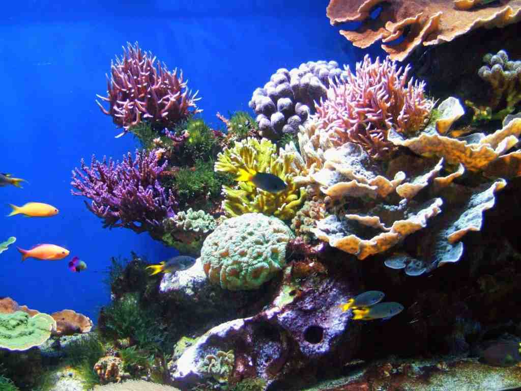
The Mesoamerica Reef – The Belize Coral Reef is the worlds second largest after Australia’s Great Barrier Reef and provides a fantastic opportunity to snorkel or scuba dive.

Beaches – For those that enjoy secluded beaches, Belize is a stunning cruise destination. There’s Ambergris Caye about 30 miles from Belize City, it is the largest island in Belize, and a major destination for travelers to Belize. San Pedro Town is the only town on the island. Ambergris Caye has been the hub of the areas maritime trade for centuries. and Caye Caulker 19 miles can be reached by water taxi.

Museum of Belize – Housed in a brick building built in 1857 as the main jail. It houses plenty of exhibits in two floors and offers interesting insights to the countries past.

St. John Cathedral – The Cathedral built in 1812 is still a functioning church, home of the Anglican Diocese of Belize. The church is open seven days a week for worship or visits from 6:00 am to 6:00 pm.

Todays Featured Poster • Ketchikan, Alaska

A popular port in Alaska, Ketchikan was founded on salmon canneries and logging. The logging business is gone and has been replaced with tourism but salmon fishing is still big business. Don’t pass up the opportunity to bring home some canned or smoked salmon. These giclée prints will soon be available in several sizes and styles, custom printed for each individual order on archival, museum grade paper using fade resistant inks.

Join us as we visit historic treasures, natural wonders and vibrant cities set against backdrops that are endlessly changing and visually magnificent. Celebrate a world of travel experiences with these decorating accessories that are perfect for framing.

Join Us – We understand that the last thing you may want is more emails cluttering up your inbox, but we promise we’ll work hard to make this worth your while. Give us a try and if we don’t live up to our promise all you need do is click the unsubscribe link in our emails.

Hiking Around Sitka, Alaska

Sitka Features Some Of Alaskas Best Hiking Trails

No other town in Alaska has as many hiking trails as Sitka. Great mountain hikes, nature walks, urban trails, history paths – Sitka is for hikers and was featured as one of America’s best towns for running trails in a recent issue of “Canadian Runner” magazine.

Indian River Trail5 miles, Easy

Near town on good ter­rain, this trail is pop­u­lar with all ages for walks and trail runs. The trail fol­lows the Indi­an Riv­er through a val­ley to a nice water­fall. Along the river is great for bird watching as well as looking for deer and additional wildlife. In late sum­mer the riv­er is a major salmon run (no fish­ing allowed).

Mosquito Cove Trail • Easy

This beau­ti­ful trail is part of an exten­sive local sys­tem of trails and board­walks. It’s pop­u­lar with locals and state fer­ry trav­el­ers, since it can be linked via trail to the fer­ry ter­mi­nal, the For­est and Muskeg Trail, and the Estu­ary Life Trail.

Sitka Nat’l Historic Park Trails • 1 mile, Easy

Begins at the Sitka Nation­al Park Ser­vice Vis­i­tor Cen­ter, it travels through coastal for­est, along a salmon stream, with great views of the shore­ and moun­tains. It also passes totem poles and historic sites, like the 1804 Bat­tle of Sit­ka. It was the last battle with the Tlin­gits in Sit­ka ending with Russ­ian rule.

Cross Trail • 7 miles , Easy

Very close to town the Cross trail inter­sects Gavan Hill Trail one mile in as it goes through thick stands of trees. Some distance after that anoth­er trail forks off leading to Sit­ka High School. After the fork the trail follows an old log­ging road that comes out behind the high school base­ball field. The trail ends short­ly thereafter.

Old Sitka State Historic Site • length varies, Easy

This location has numer­ous hik­ing trails with fantastic inter­pre­tive signs. It is also a historic location being the site of the first Russ­ian set­tle­ment on Bara­nof Island.

Sitka Causeway Trail Distance • 1 mile, Easy

Fort Rousseau State Historical Park – Best to take a water taxi to the arch­i­pel­ago running out into Sit­ka Sound. It’s a rel­ic of decay­ing for­ti­fi­ca­tions built to defend Alas­ka from for­eign inva­sion dur­ing World War II. Dur­ing World War II, Sit­ka was the hub of mil­i­tary activ­i­ty in South­east Alas­ka, with a U.S. Naval Air Sta­tion

Halibut Point State Recreation Area • 1 mile, Easy

A great water­front location with cov­ered shel­ters. A favorite pass time at low tide is visiting Mag­ic Island and exploring the numerous tidal pools looking for sea crea­tures. A nice one-mile loop trail goes through the park passing an inter­est­ing mod­ern totem pole.

Forest & Muskeg Trail • Easy

This is one of the more scenic trails and great for hik­ers of all skill levels. Featuring inter­pre­tive trail markers keyed with a self-guid­ed brochure. Hike through exam­ples of the local for­est ecosys­tems. Learn about the Alaska ecolo­gies while hiking gen­tly slop­ing trails and board­walks. Access the trail by starting at Old Sit­ka State Park locat­ed just ¼ mile north of the Ferry Terminal.

The “Fortress of the Bear” is a bear rescue facility located on the outskirts of the town of Sitka and is open to the public.

Todays Featured Poster • The Pebble Beach Cyprus

The Lone Cypress above is a Monterey cypress tree located in Pebble Beach, California. Standing atop a granite headland overlooking Carmel Bay, the tree has become an icon and has been called one of the most photographed trees in North America. This lone cypress is part of two original stands of trees that are now protected in the Del Monte Forest of Pebble Beach and the Point Lobos Reserve. Every televised golf tournament from Pebble Beach will always show the iconic Lone Cypress.

Join us as we visit historic treasures, natural wonders, vibrant cities all set against backdrops that are endlessly changing and visually magnificent. Celebrate a world of travel experiences with these posters as decorating accessories that are perfect for framing.

Cruise Port Amsterdam

Amsterdam, Heart of The Netherlands

Approaching The Netherlands from the North Sea cruise ships navigate the North Sea Canal. The canal runs from the IJmuiden locks to the Coenhaven. East of the Coenhaven, the waterway is called the River IJ (both letters are capitalized) and continues up to the Oranjesluizen locks located in the eastern part of Amsterdam. Than from the Oranjesluizen up to the Passenger Terminal in Amsterdam. Unfortunately ships that are transiting into Amsterdam often come in before dawn so as to be tied up early in the day. Passengers that are sailing out of Amsterdam late in the day get a much better appreciation of the systems that protect Holland from the North Sea.

Amsterdam is the largest city in the Netherlands and it’s famous for tulips, cheese, marijuana, red light districts and canals. Many people call the country Holland but the true name is the Netherlands with Holland being the name of two of its states. The people are Dutch as is the name of their language.

The most important thing to know about Amsterdam is when walking in the city, pay attention and stay out of the bike lanes and always watch out for bikes! Everyone rides bikes to get around in this city and in most areas there is a designated bike lane between the sidewalks and the street. The biggest mistake visitors make is seeing the light change, traffic stop and step off the sidewalk without looking for bicycles. Keep you eyes open for bikes – a bicyclist moving at ten miles an hour can do a lot of damage to a pedestrian.

Where Your Ship Docks

Your ship will dock at the Cruise Terminal on the river IJ. The cruise facilities are modern with good access to public facilities. From the terminal it is just a 10-minute walk to the central train station. With the cruise ship at your back walk off to your right along the waterfront to reach the station and central Amsterdam.

The cruise terminal is only a 20 minute ride from Amsterdam’s Schiphol Airport and just a ten minute walk to Amsterdam Central Train station. There is also frequent train service from the station to Schiphol Airport. Amsterdam also has an excellent and inexpensive bus system.

Wheelchair Accessibility

Disembarking – This port provides a modern cruise terminal with built-in provisions for passengers using wheelchairs like ramps and elevators.

Port City Characteristics – This port has a well developed wheelchair friendly infrastructure. The port area is flat or has few inclines. Intersection crosswalks have few issues with curbs or other wheelchair obstacles.

Getting Around The City

The city is laid out like a fan with major streets radiating out from the Amsterdam Central Train station. The major canals arc across the fan along with a number of city streets. Most major streets are serviced by trams which run every few minutes.

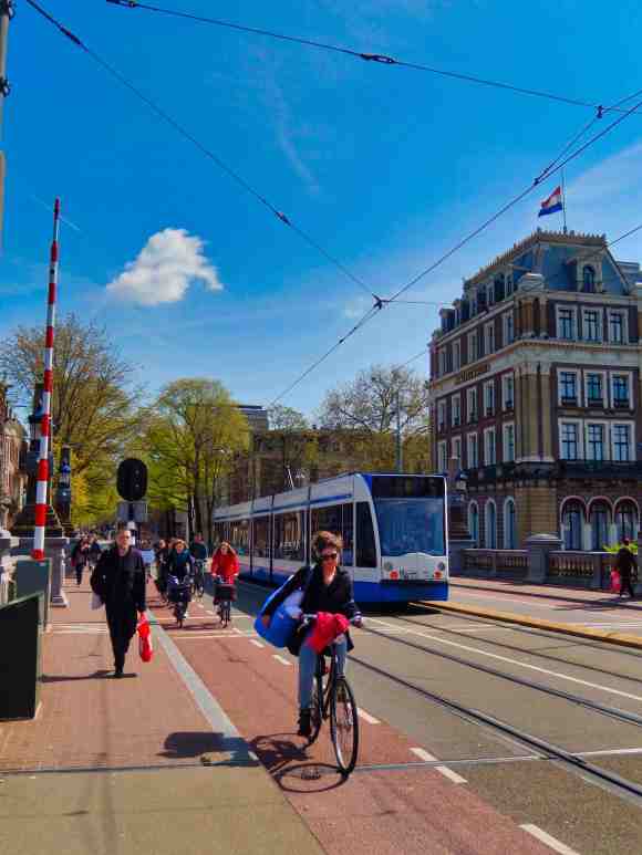
Traveling within Amsterdam by public transportion is easy to understand and very convenient. The network is operated by GVB throughout the central city and connects its neighborhoods with trains, trams, metro, bus and ferry. The least expensive and most convenient way to see the city is with GVB day passes. Available from 1 to 7 days, with prices starting from €8.50 per person, per day and valid on trams, buses and metros operated throughout Amsterdam. You can buy your tickets in advance from the GVB website HERE.

The Netherlands, like other members of the EU uses the euro as its official currency. You will often discover that to avoid the use of the 1 and 2 cent coins, many cash transactions are rounded to the nearest five cents in the Netherlands. Credit and debit cards a commonly accepted but U.S. Dollars need to be changed into Euros.

This is a beautiful city and great for walking (watch out for the bicycles!). Canals lined with boats are at every turn and like most major cities there are books dedicated to seeing this city. Museums, galleries, gardens and historic places are everywhere but often it’s just the cities neighborhoods that make a visit memorable.

Attractions

Rijksmuseum – One of Amsterdam’s most popular attractions – and certainly its most important art repository – the Rijksmuseum was founded in 1809 to house the country’s huge collection of rare art and antiquities.

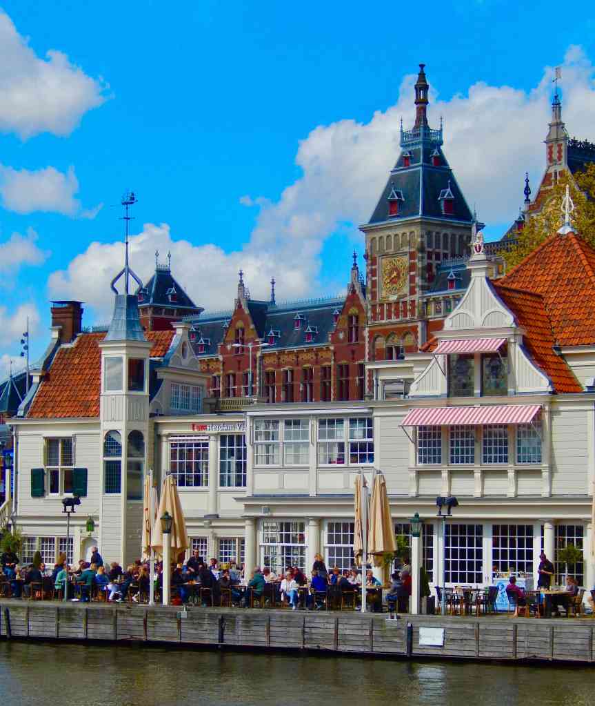
Van Gogh Museum – A must-visit for art fans and historians, the spectacular Van Gogh Museum has been one of Amsterdam’s top attractions since it opened in 1972.

Vondelpark – The largest and most visited park in Amsterdam, Vondelpark occupies 116 acres.

The Anne Frank House – On the Prinsengracht, the Anne Frank Museum is dedicated to the all-too-short life of one of the world’s best-known Holocaust victims.

If you are visiting in the Spring (usually from late March through early May) a must see is the Keukenhof Gardens, one of the worlds largest flower festivals featuring acres of tulips. Visit our article on the Keukenhof  HERE.

CLICK MAP TO DOWNLOAD A COPY

The Port of Barcelona, Spain

One of Europes major cruise ports Barcelona is worth a couple of days spent exploring, sampling the food and visiting the shops. Easy to get around in and very walkable.

Information at a glance for Barcelona

Port of Call Barcelona Spain

Barcelona is one of the two largest cruise ports in the Mediterranean and is used as an embarkation port as well as a popular port of call. The city is a modern and historic place with a number of iconic neighborhoods and attractions. If you are cruising out of Barcelona do not miss the opportunity to spend a couple of extra days visiting this vibrant city.

Where Your Ship Docks – The entrance to the Barcelona ports and the port shuttle bus stop is at Plaça de les Drassanes just south of the Columbus Monument. The location is very near the foot of La Rambla, a major street which runs through the city centre. For cruise ships there are generally three major port terminal areas. Most cruise ships are docked at Adossat Quay Terminal which is the farthest out and is serviced by a shuttle to the La Rambla area. This includes terminals A, B, C and D.

Barcelona Harbor

There are also 3 terminals at the World Trade Centre pier called North, South and East terminals and are much closer to the Columbus Monument on the waterfront at La Rambla.

The third terminal is Sant Bertrand, and it to is near the World Trade Center (refer to our cruise terminal map). Sant Bertrand is usually used for ferries to the Balearic Islands.

The Shuttle – The T3 PORTBUS (the “Blue Bus”) runs a circuit from all cruise port terminals to near the monument of Christopher Columbus. The tickets for the T3 need to be purchased with cash on the bus itself.

At this writing the tickets cost:

Single ticket: €3.00

With Return ticket: €4.00

The Sagrada Familia

Many of the cruise ships also provide a shuttle bus to their passengers for free or a small charge.

Walking – The nearest cruise terminal to La Rambla is about a 15 minute walk away. However the major cruise terminals, which are furthest from La Rambla are about a mile and a quarter (2 Km) from the Columbus Monument. From Christopher Columbus monument to La Rambla is about a 1 minute walk, and the nearest Metro is Drassanes (Green Line, L3), which is another 5 minutes walk.

Barcelona Metro – Barcelona has a good transit system that is excellent for getting around the city. The Barcelona Tourist Travel Pass (also known as the HolaBCN card) is a transport pass specifically designed for tourists. Once purchased it enables you to have unlimited journeys on the Barcelona public transport system which includes the TMB buses from Barcelona Airport to the city centre, the Airport metro from both T1 and T2, the Airport train to the city centre, the entire metro underground system in the whole of the city, the TMB buses that run in the city centre and the suburban tram system. Barcelona Card gives you unlimited transport on the Barcelona transport system (metro, bus, tram). It can be purchased in advance of your trip (save 10%). The Transport Card can be purchased for 2 to 5 days with a 2 day card at €16.40.

There are also a number of tour buses like Hop Off Hop On and you can find more information HERE.

Taxi – A taxi from the port to the city centre is normally less than 10 minutes with a fare of about €20.00. A Taxi to Barcelona airport from the cruise port should take about 25 minutes with a fare: of €30.00 – €35.00.

What To See – Barcelona is a city steeped in culture and history and many think it is the city itself that is the main attraction. From great food to an exciting night life, from the old Gothic quarter to the modern shopping districts this is a truly remarkable city.

Barcelona is famous for the fantastic architecture of Antonio Gaudí, whose buildings can be found scattered around the city. The most famous can be found along Passeig de Gràcia where you will find La Pedrera and Casa Batlló. There is also the Parc Güell which is a incredible park designed by Gaudí himself. The most notable of Gaudí’s works is the Sagrada Familia, the huge, still unfinished Basilica.

The Gothic Cathedral in the heart of the Gothic quarter is a must-see as is a walk up Las Ramblas. Make sure to save time to explore the winding side streets with their shops and restaurants.

There are also a number of great museums in the city. The MACBA (museum of modern art) and the CCCB next door are worth an hour or two. The Picasso and the permanent Dalí exhibition in the Gothic Quarter are always worth a visit. The Caixa Forum is a museum which has different art exhibitions every month. It is just off Plaça Espanya, on Avenida Marques.

If you have more than a few hours be sure and visit the Poble Espanyol, an open-air architectural museum in Barcelona. Located approximately a quarter mile away from the Fountains of Montjuïc. It was built for the 1929 Barcelona International Exposition (Worlds Fair), the museum consists of 117 full-scale buildings replicated from different places in Spain, together making up a small town recreating urban atmospheres. It is full of cafes, restaurants, small shops and exhibits.