A Planned Trip Up The Blue Ridge Parkway
The Blue Ridge Parkway is actually the most visited of all American National Parks. The Parkway extends 469 miles mostly along the crest of the Blue Ridge mountains through North Carolina and Virginia. It encompasses some of the oldest sites of both prehistoric and early European settlement in the country. Colonel Joseph Hyde Pratt first suggested the parkway in 1912, and it was begun during the administration of President Franklin D. Roosevelt. The project was a major contributor to helping the people of the area get through the Great Depression with significant work done using the Civilian Conservation Corp. Originally called the Appalachian Scenic Highway it wasn’t actually completely finished until 1987. The Blue Ridge Parkway contains almost 400 miles of hiking trails that aren’t just a natural wonderland but offer a remarkable window into the history of the mountains. Much of the Parkway’s trails and exhibits deal with the first hundred years in this country as settlers moved west seeking land and opportunity and leaving a permanent mark on the mountains.

Below you will find a directory of the hiking trails along the Parkway and a copy of The National Park Service map of the parkway in one complete downloadable HD pdf.
We hope you find our copy of the map and the trail guide useful.
Please Note: A Blue Ridge Parkway trip is measured by mile markers or posts starting with 0 at the entrance in Virginia all the way to MP 469 at its end in Cherokee, North Carolina. The location of trails are marked by these mile posts (MP).
LOCATION OF BLUE RIDGE VIRGINIA HIKING TRAILS BY MILEPOST NUMBER
Milepost 5.9 – Mountain Farm Trail (self-guiding, from Humpback Visitor Center to pioneer farmstead) Length: 0.25 Miles Skill Level: Easy
Milepost 6 – Appalachian Trail (Humpback Gap parking area to Humpback Mtn., elev. – 3650 feet) Length: 2 Miles Skill Level: Strenuous
Milepost 8.4 – Catoctin Loop Trail (leg stretcher) Length: 0.3 Miles Skill Level: Moderate
Milepost 8.8 – Greenstone Trail (self-guiding; Greenstone geology formation; oak hickory forest) Length: 0.2 Miles Skill Level: Moderate
Milepost 17.6 – The Priest (view) Length: 0.1 Miles Skill Level: Easy
Milepost 18.5 – White Rock Falls Trail Connection Length: 2.9 Miles Skill Level: Moderate
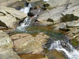
Milepost 20 – White Rock Falls Trail (follows stream to small falls) Length: 0.9 Miles Skill Level: Moderate
Milepost 26.3 – Big Spy Mountain (view into Shenandoah Valley; good for stargazing) Length: 0.1 Miles Skill Level: Moderate

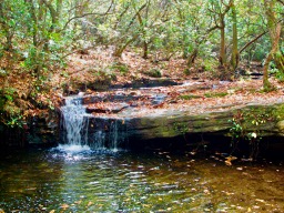
Milepost 34.4 – Yankee Horse (to logging RR exhibit & small waterfall) Length: 0.2 Miles Skill Level: Moderate
Milepost 38.8 – Boston Knob (leg stretcher) Length: 0.1 Miles Skill Level: Easy
Milepost 47.5 – Indian Gap (to Indian Rocks; good seasonal rhododendron display) Length: 0.3 Miles Skill Level: Moderate
Milepost 55.2 – White Oak Flats (leg stretcher) Length: 0.1 Miles Skill Level: Easy
Milepost 60.8 – Otter Creek Trail (begin at Otter Creek Campground) Length: 3.5 Miles Skill Level: Moderate
Milepost 63.1 – Otter Lake Trail (around Otter Lake) Length: 0.8 Miles Skill Level: Moderate
Milepost 63.6 – James River Trail (Self-guiding to canal locks) Length: 0.2 Miles Skill Level: Easy
Trail of Trees Trail (self-guiding to James River Overlook) Length: 0.5 Miles Skill Level: Moderate
Milepost 74.7 – Thunder Ridge Trail (leg stretcher loop to view of Arnold Valley) Length: 0.1 Miles Skill Level: Easy
Milepost 78.4 – Apple Orchard Falls Trail (Sunset Field Overlook to view of Apple Orchard Falls; National Recreation Trail) Length: 1.2 Miles Skill Level: Strenuous
Milepost 79.7 – Onion Mountain Loop Trail (leg stretcher through Appalachian deciduous forest with rhododendron display) Length: 0.1 Miles Skill Level: Easy
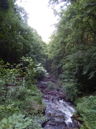
Milepost 83.1 – Fallingwater Cascades Trail (National Recreation Trail; loop to view of cascades) Length: 1.6 Miles Skill Level: Moderate
Milepost 83.5 – Flat Top Trail (leads to highest of three prominent peaks in area) Length: 4.4 Miles Skill Level: Moderate
Cross Rock Trail (spur off Flat Top Trail; unique geological features) Length: 0.1 Miles Skill Level: Moderate
Milepost 85.7 – Abbott Lake Trail (loop around Abbott Lake) Length: 1.0 Miles Skill Level: Easy
Milepost 85.9 – Elk Run Trail (self-guiding loop nature trail from Peaks of Otter Visitor Center) Length: 0.8 Miles Skill Level: Easy
Johnson Farm Loop Trail (loop to restored mountain farm) Length: 2.1 Miles Skill Level: Moderate
Harkening Hill Trail (elevation -3300 feet; begin at Peaks of Otter Visitor Center) Length: 3.3 Miles Skill Level: Moderate
Balance Rock (spur trail off Harkening Hill Trail; unique geological formations) Length: 0.1 Miles Skill Level: Moderate
Milepost 86 – Sharp Top Trail (from camp store to summit of Sharp Top Mtn.; elevation – 3875 feet; 360 degree panoramic view) Length: 1.5 Miles Skill Level: Strenuous
Milepost 91 – Appalachian Trail (VA 695 to Sharp Top Mtn. Overlook) Length: 1.9 Miles Skill Level: Moderate
Milepost 92.5 – Appalachian Trail (Sharp Top Mtn. Overlook to Harvey’s Knob Overlook) Length: 2.9 Miles Skill Level: Moderate
Milepost 95.4 – Appalachian Trail (Harvey’s Knob Overlook to Motvale Overlook) Length: 0.6 Miles Skill Level: Moderate
Milepost 95.9 – Appalachian Trail (Montvale Overlook to Taylor’s Mountain Overlook) Length: 1 Miles Skill Level: Moderate
Milepost 96 – Spec Mine Trail (USFS Trail begins near Montvale Overlook, to State Rt. 645 in Botetourt County) Length: 2.8 Miles Skill Level: Strenuous
Milepost 97 – Appalachian Trail (Taylor’s Mtn. Overlook to Blackhorse Gap) Length: 0.8 Miles Skill Level: Moderate
Milepost 110.6 – Stewarts Knob Trail (view) Length: 0.05 Miles Skill Level: Easy
Milepost 114.9 – Roanoke River Trail (self-guiding river loop) Length: 0.35 Miles Skill Level: Easy
Milepost 120.4 – Roanoke Mountain Summit Trail (view) Length: 0.11 Miles Skill Level: Moderate
Milepost 120.5 – Chestnut Ridge Trail (adjacent to Roanoke Mtn. Campground) Length: 1.75 Miles Skill Level: Moderate
Milepost 121.4 – Roanoke Valley Horse Trail (begins US Hwy 220, parallels Parkway to Milepost 110.6) Length: 18.5 Miles Skill Level: Moderate
Milepost 123.2 – Buck Mountain Trail (to summit view) Length: 0.53 Miles Skill Level: Moderate
Milepost 154.5 – Smart View Loop Trail (around picnic area) Length: 2.6 Miles Skill Level: Moderate
Milepost 167.1 – Rock Castle Gorge Trail (loop from campground along ridge over Rocky Knob and into gorge for 7-mile return to campground) Length: 10.8 Miles Skill Level: Strenuous
Hardwood Cove Self-Guiding Nature Trail (part of Rock Castle Loop) Length: 0.8 Miles Skill Level: Moderate
Milepost 169 – Black Ridge Trail (Rocky Knob Visitor Center to Black Ridge to Grassy Knoll and back to Visitor Center) Length: 3.1 Miles Skill Level: Moderate
Rocky Knob Picnic Loop Trail (leg stretcher around picnic area) Length: 1.0 Miles Skill Level: Easy
Milepost 176.2 – Mountain Industry Trail (Mabry Mill) Length: 0.5 Miles Skill Level: Easy
Milepost 179.2 – Round Meadow Creek Loop Trail (walk through a stream bottom forest) Length: 0.5 Miles Skill Level: Moderate
Milepost 213 – High Meadow Trail (leg stretcher) Length: 1.35 Miles Skill Level: Easy
Fisher Peak Loop Length: 2.25 Miles Skill Level: Moderate
NORTH CAROLINA TRAILS BY MILEPOST
Milepost 217.5 – Cumberland Knob Trail (ideal lazy-day walk) Length: 0.5 Miles Skill Level: Easy
Gully Creek Trail (rewarding loop that meanders by stream) Length: 2 Miles Skill Level: Strenuous
Milepost 218.6 – Fox Hunters Paradise Trail (view) Length: 0.2 Miles Skill Level: Easy
Milepost 230.1 – Little Glade Millponds (easy loop stroll around pond) Length: 0.4 Miles Skill Level: Easy
Milepost 238.5 – Cedar Ridge Trail (great for day hike; vistas and forests) Length: 4.2 Miles Skill Level: Moderate
Bluff Mountain Trail (parallels Parkway to Milepost 244.7) Length: 7.5 Miles Skill Level: Moderate
Milepost 241 – Fodder Stack Trail (great variety of plants) Length: 2.89 Miles Skill Level: Strenuous
Milepost 243.7 – Grassy Gap Fire Road (wide enough for side-by-side hiking) Length: 6.5 Miles Skill Level: Moderate
Basin Creek Trail (access from back-country campground) Length: 3.3 Miles Skill Level: Moderate
Milepost 244.7 – Flat Rock Ridge Trail (forest path with vistas) Length: 5.0 Miles Skill Level: Moderate
Milepost 260.3 – Jumpingoff Rocks Trail (forest path to vista) Length: 1.0 Miles Skill Level: Easy
Milepost 264.4 – The Lump Trail (to hilltop view) Length: 0.3 Miles Skill Level: Easy
Milepost 271.9 – Cascades Trail (self-guiding loop to view of falls) Length: 0.5 Miles Skill Level: Moderate
Milepost 272.5 – Tompkins Knob Trail (to Jesse Brown Cabin) Length: 0.6 Miles Skill Level: Easy
Milepost 294 – Rich Mountain Carriage, Horse, & Hiking Trail Length: 3 Miles Skill Level: Moderate
Flat Top Mountain Carriage, Horse & Hiking Trail Length: 3 Miles Skill Level: Moderate
Watkins Carriage, Horse & Hiking Trail Length: 3.3 Miles Skill Level: Easy/Moderate
Black Bottom Carriage, Horse, & Hiking Trail Length: 0.5 Miles Skill Level: Easy
Bass Lake Carriage, Horse & Hiking Trail Length: 1.7 Miles Skill Level: Easy
Deer Park Carriage, Horse, & Hiking Trail Length: 0.8 Miles Skill Level: Moderate
Maze Carriage Horse & Hiking Trail Length: 2.3 Miles Skill Level: Moderate
Duncan Carriage, Horse, & Hiking Trail Length: 2.5 Miles Skill Level: Moderate
Rock Creek Bridge Carriage, Horse, & Hiking Trail Length: 1.0 Miles Skill Level: Easy
Milepost 294.1 – Figure 8 Trail (short, self-guiding loop nature trail) Length: 0.7 Miles Skill Level: Easy
Milepost 294.6 – Trout Lake Hiking & Horse Trail (loop) Length: 1.0 Miles Skill Level: Easy
Milepost 295.9 – Green Knob Trail (to Green Knob) Length: 2.3 Miles Skill Level: Moderate/Strenuous
Milepost 296.4 – Boone Fork Trail (stream, forest, and meadows) Length: 4.9 Miles Skill Level: Moderate/Strenuous
Milepost 297 – Price Lake Loop Trail (loop around Price Lake) Length: 2.3 Miles Skill Level: Moderate
Milepost 304.4 – Linn Cove Viaduct Access Trail Length: 0.16 Miles Skill Level: Easy
Milepost 305.2 – Beacon Heights Trail (10 minutes to view) Length: 0.22 Miles Skill Level: Moderate
Tanawha Trail (diverse biological and geological features) Length: 13.5 Miles Skill Level: Easy/Moderate
Milepost 308.2 – Flat Rock Trail (self-guiding loop) Length: 0.63 Miles Skill Level: Easy
Milepost 315.5 – Camp Creek Trail (leg stretcher throught laurel and rhododendron) Length: 0.1 Miles Skill Level: Easy
Milepost 316.4 – Linville Falls Trail (view of upper Falls) Length: 0.8 Miles Skill Level: Moderate

Linville Gorge Trail (view of lower Falls) Length: 0.5 Miles Skill Level: Strenuous
Duggers Creek Trail (loop to view of Duggers Falls) Length: 0.25 Miles Skill Level: Easy
Milepost 316.5 – Linville River Bridge Trail (leg stretcher to view of unusual bridge) Length: 0.1 Miles Skill Level: Easy
Milepost 320.8 – Chestoa View Trail (30-minute loop to vista) Length: 0.63 Miles Skill Level: Easy
Milepost 339.5 – Crabtree Falls Loop Trail (loop to view of Falls) Length: 2.0 Miles Skill Level: Strenuous
Milepost 344.1 – Woods Mountain Trail (USFS) Length: 2.0 Miles Skill Level: Moderate
Milepost 350.4 – Lost Cove Ridge Trail (USFS) Length: 0.6 Miles Skill Level: Moderate
Milepost 351.9 – Deep Gap Trail (USFS) Length: 0.2 Miles Skill Level: Easy
Milepost 355 – Bald Knob Ridge Trail (USFS) Length: 0.1 Miles Skill Level: Easy
Milepost 355 – Big Butt Trail (trail continues on USFS lands) Length: 0.2 Miles Skill Level: Strenuous
Milepost 361.2 – Glassmine Falls (view of Falls) Length: 0.05 Miles Skill Level: Moderate
Milepost 361.2 – Craggy Pinnacle Trail (to panoramic view) Length: 0.73 Miles Skill Level: Moderate
Milepost 364.2 – Craggy Gardens Trail (first portion is self-guiding nature trail) Length: 0.84 Miles Skill Level: Moderate
Milepost 374.4 – Rattlesnake Lodge Trail (woodland walk) Length: 0.5 Miles Skill Level: Moderate
Milepost 382 – Mountain-to-Sea Trail/MTS Trail (from Folk Art Center to Milepost 365, spring wildflowers and views, parallels parkway, many accesses) Length: 7.5 Miles Skill Level: Moderate
Milepost 393.7 – Shut-In Trail/MTS Trail (Bent Creek-Walnut Cove) Length: 3.1 Miles Skill Level: Strenuous
Milepost 397.3 – Grassy Knob Trail (steep trail to USFS area) Length: 0.9 Miles Skill Level: Strenuous
Shut-In Trail/MTS Trail (Sleepy Gap-Chestnut Cove)Length: 0.7 Miles Skill Level: Moderate
Milepost 398.3 – Shut-In Trail/MTS Trail (Chestnut Cove-Bent Creek Gap) Length: 2.8 Miles Skill Level: Strenuous
Milepost 400.3 – Shut-In Trail/MTS Trail (Bent Creek Gap-Beaver Dam Gap) Length: 1.9 Miles Skill Level: Moderate
Milepost 401.7 – Shut-In Trail/MTS Trail (Beaver Dam Gap-Stoney Bald) Length: 0.9 Miles Skill Level: Moderate
Milepost 402.6 – Shut-In Trail/MTS Trail (Stoney Bald-Big Ridge) Length: 1.2 Miles Skill Level: Strenuous
Milepost 403.6 – Shut-In Trail/MTS Trail (Big Ridge-Mills River Valley) Length: 1.2 Miles Skill Level: Moderate/Strenuous
Milepost 404.5 – Shut-In Trail/MTS Trail (Mills River Valley-Elk Pasture Gap) Length: 1.2 Miles Skill Level: Moderate/Strenuous
Milepost 405.5 – Shut-In Trail/MTS Trail (Elk Pasture Gap-Mt. Pisgah)Length: 1.7 Miles Skill Level: Strenuous
Milepost 407.6 – Mt. Pisgah Trail (summit view) Length: 1.26 Miles Skill Level: Moderate/Strenuous
Buck Springs Trail (Pisgah Lodge to view)
Milepost 408.5 – Frying Pan Mountain Trail Length: 1.65 Miles Skill Level: Moderate/Strenuous
Milepost 417 – East Fork Trail (USFS, access to Shining Rock Trail System) Length: 0.1 Miles Skill Level: Easy/Moderate
Milepost 418.8 – Graveyard Fields Loop Trail (loop by a stream) Length: 2.29 Miles Skill Level: Moderate
Milepost 419.4 – John Rock Trail (leg stretcher to view) Length: 0.1 Miles Skill Level: Easy
Milepost 422.4 – Devil’s Courthouse Trail (panoramic summit view) Length: 0.42 Miles Skill Level: Moderate/Strenuous
Milepost 427.6 – Bear Pen Gap Trail (access to Mountains-to-Sea Trail) Length: 0.22 Miles Skill Level: Easy
Milepost 431 – Richland Balsam Trail (self-guiding loop through spruce-fir forest) Length: 1.47 Miles Skill Level: Moderate
Milepost 433.8 – Toy Taylor Overlook Trail (paved trail to overlook) Length: 0.1 Miles Skill Level: Easy
Milepost 451.2 – Waterrock Knob Trail (summit view) Length: 1.18 Miles Skill Level: Moderate/Strenuous