An Afternoon In The Dharavi Slum

Mumbai India’s Famous Dharavi Slum

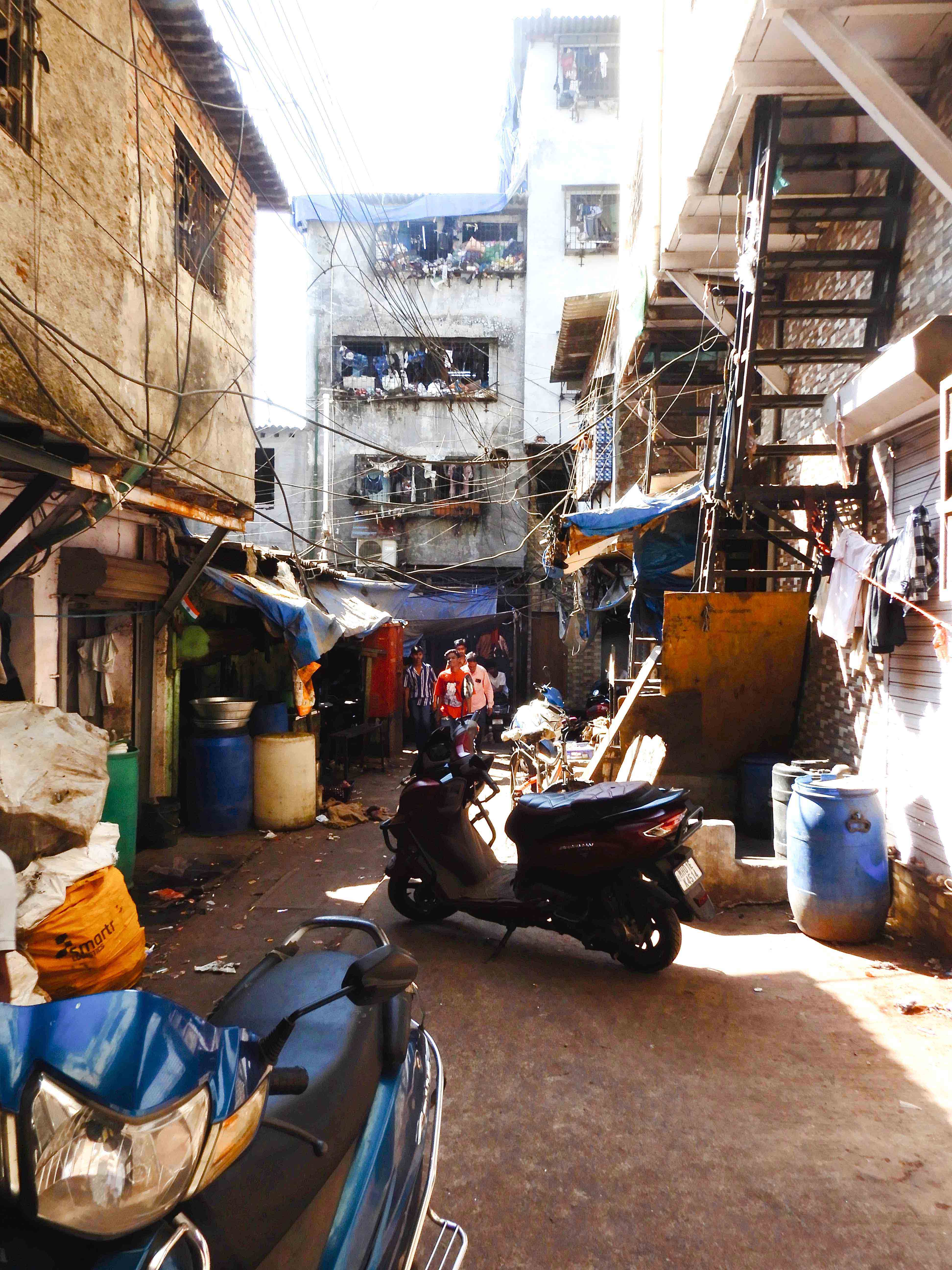
The Dharavi Slum is located in central Mumbai, India and is famous as one of the largest slums in the world. It is estimated to have a population of over 1 million people in an area just over 2 square kilometers. Whatever notions people may have about this place, they’re probably mostly wrong.

many reports, the people of Dharavi are not squatters or beggars but actually have title to the land and work in remarkably industrious shops. Surprisingly, the slum is home to a huge and thriving economy.

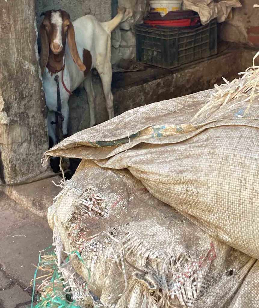
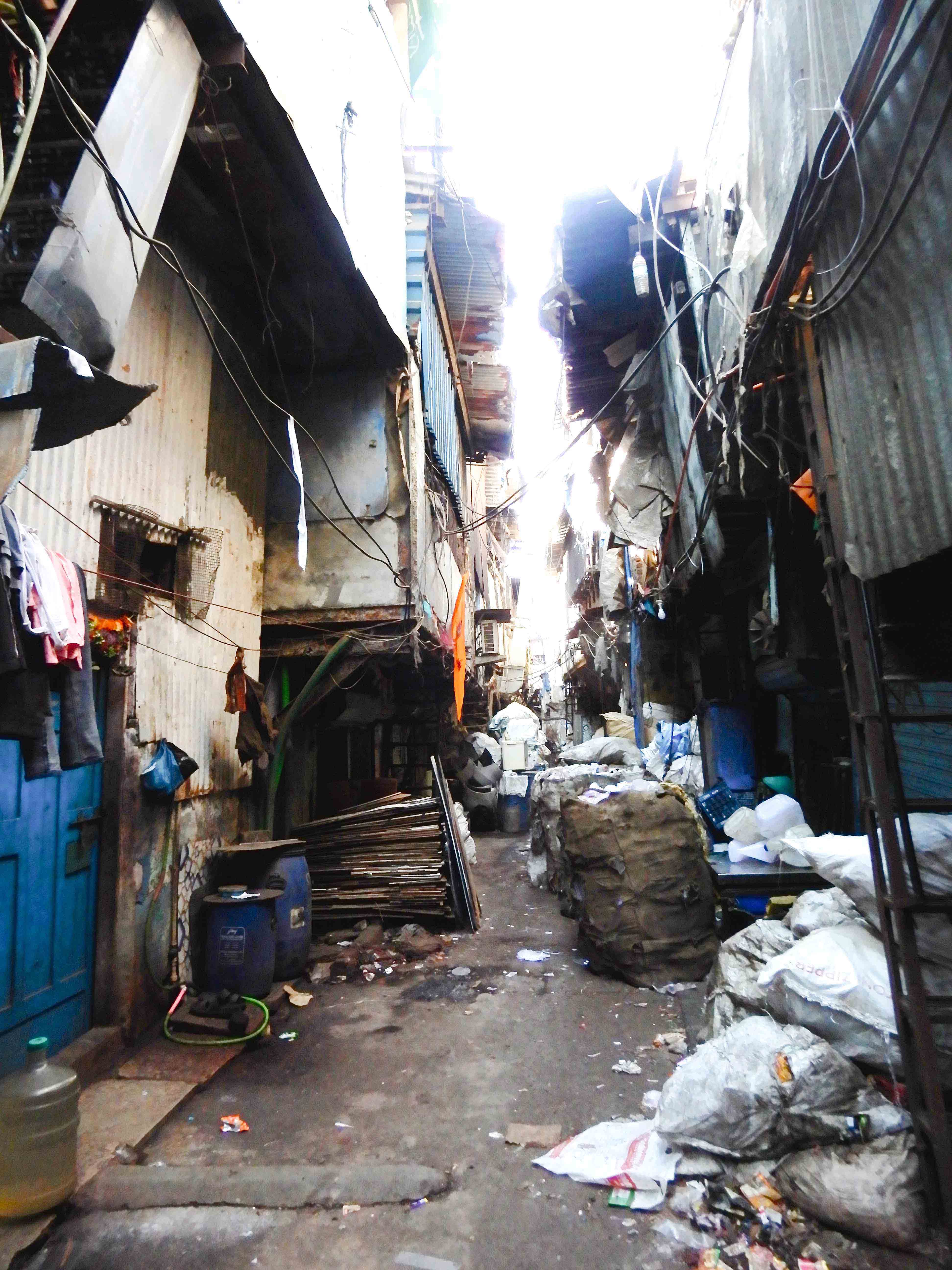
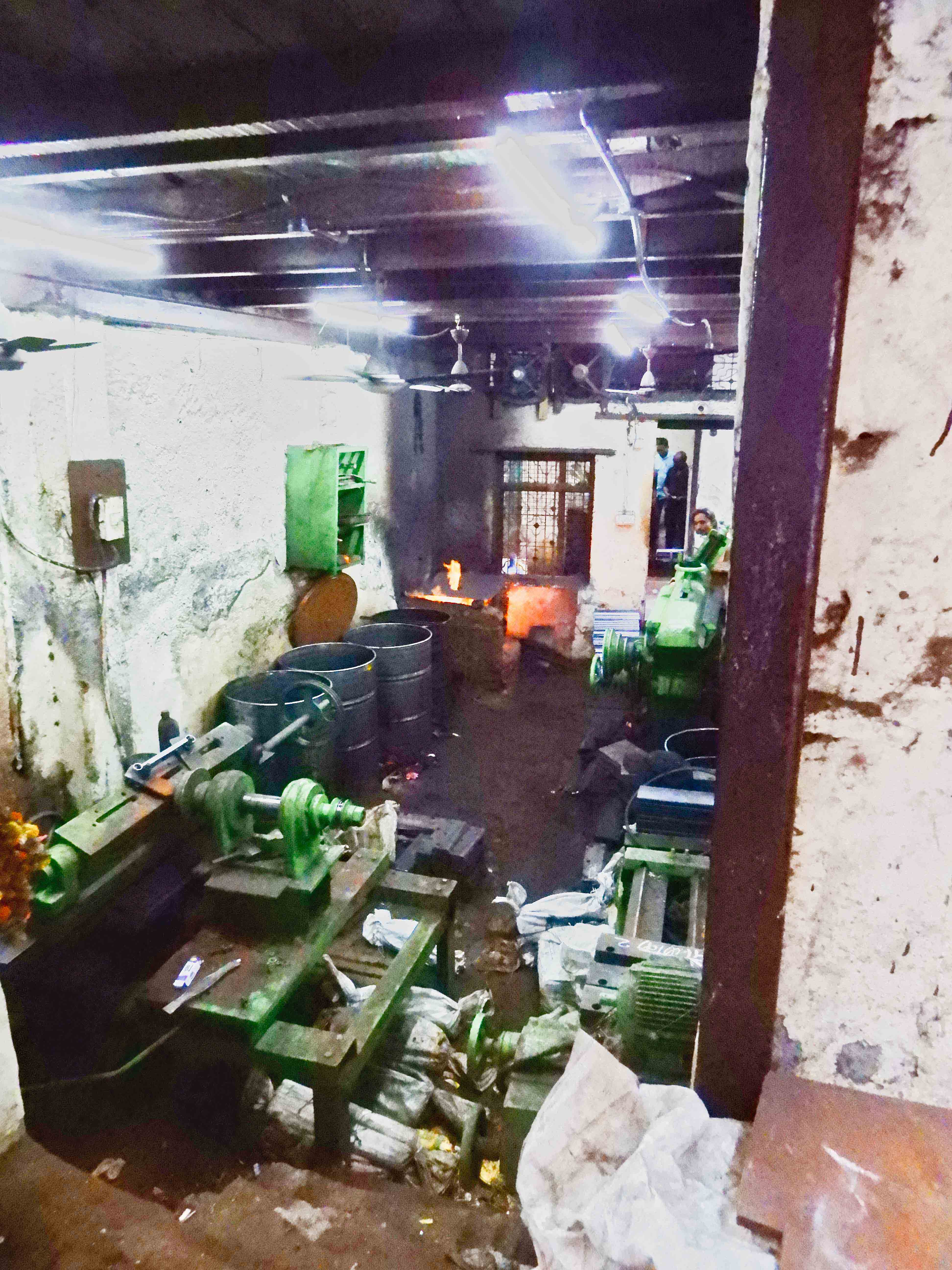
Recycling is the major business along with textile dyeing, sewing, leather working and small scale manufacturing. The largest recycling is in plastics. Operators sort plastics from city trash into categories based on the types of plastic and colors. Its washed, shredded or chipped and sealed in bags. A manufacturing company can come to shops in Dharavi and buy specific weights and colors of the plastic they need cheaper than formulating the resins from scratch.

Smaller shops tan hides and turn the leathers into copies of expensive skins like alligator and snake. Many shops produce high quality, handmade luggage and handbags while others are famous for pottery and ceramics. It is estimated that the economic turnover of the accumulated businesses in Dharavi is above one billion US Dollars a year.

Dharavi was originally a marshy area that was used as a dumping ground for the city of Mumbai. In the 19th century, it became home to a large number of migrants from rural areas who migrated to Bombay to work in the city’s thriving textile mills.

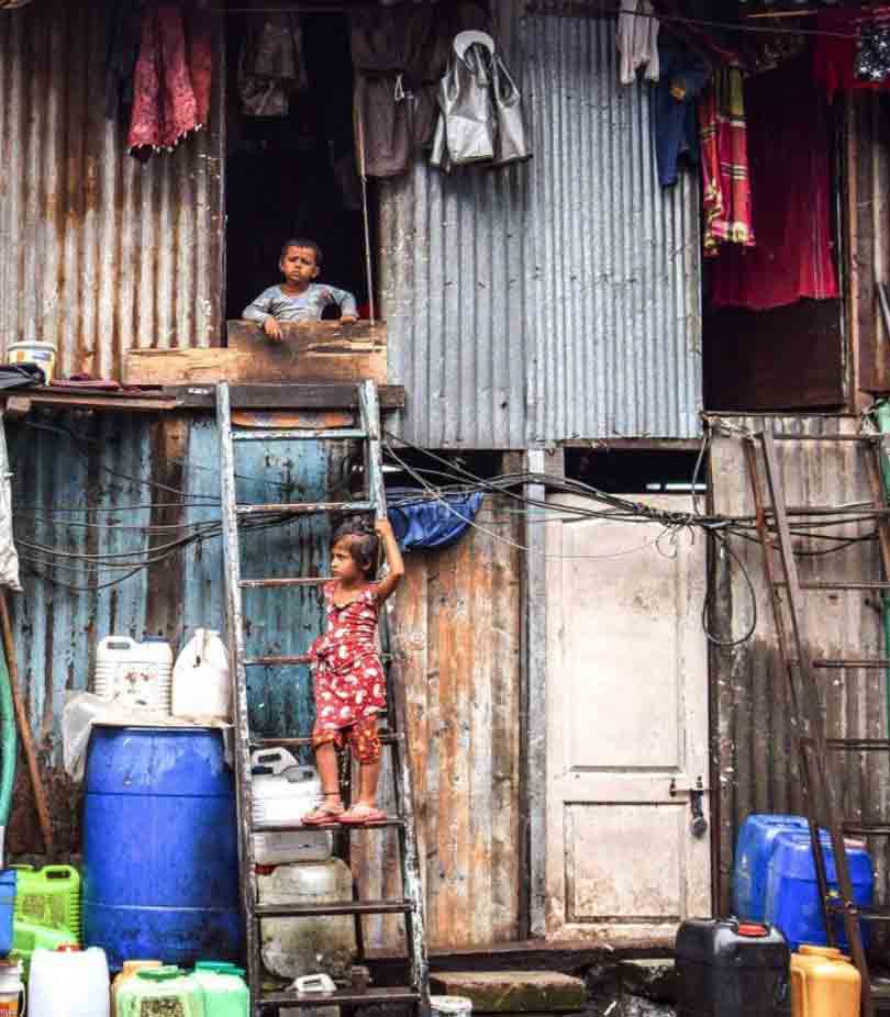
The residents are noted for working together to overcome the challenges of overcrowding, poor sanitation, and lack of access to basic services. It is a vibrant community with a strong sense of identity. The residents have organized and run upwards of 250 schools for the children, adopt rules for the use of resources and contribute to operate clinics and public safety organizations.

When visiting Mumbai there are a number of tours that can be organized to visit Dharavi and most will explain that there are certain rules you will need to observed. Do not point cameras or cell phones at the people, they are not an attraction and find that offensive. Also compared to the streets of Mumbai, Dharavi is surprisingly safe but do not wander off on your own. The two acres of Dharavi is a compact maze and it is very easy to get completely lost.

One of Dharavis many schools

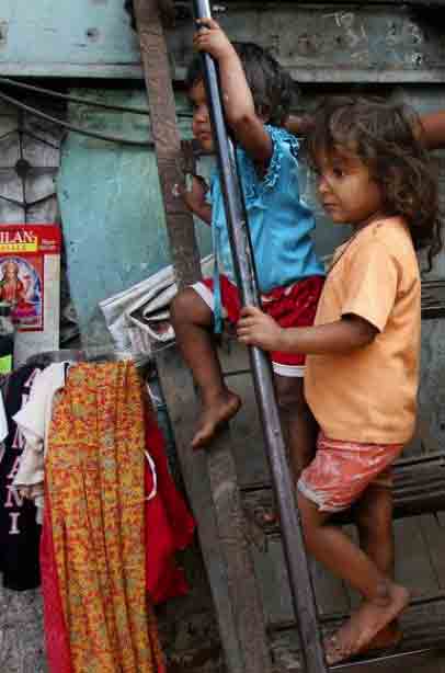
During our visit the children were remarkable. Most between the ages of 4 and 6 would run up to us and want to fist bump. It became a game after which they would ask our names and country and then run away laughing and singing our names. It was good “old fashioned” fun. No cell phones or electronic devices anywhere!

 
Through a contact before we left for Mumbai we were given information on a guide to get in touch with. We contacted Ahad and used him and his associates for a number of tours and couldn’t have been more pleased. You can reach him at:

Ahad Sayed <sayedahad02@gmail.com> Phone: +919867722048

Please mention The Intentional Travelers if you contact him. We receive no commission or other consideration should you use Ahad. 

Yokohama – Lost In Translation

A Cautionary Tale About Using MyTransfers.com For Japan

Update: Please note that we contacted MyTransfers.com about our problem with their service in Yokohama and they were very responsible in responding and provided us with a reasonable resolution.

Often, when traveling internationally, you need to take a lot on faith. Will your flight arrive on time? Will the arranged driver actually be there? Will taxis accept credit cards? Do we have all the necessary documents? Is it safe to prepay for a service?

First, in our case we do everything we can to avoid paying in advance and that often means paying a higher price. Better to pay a slighter higher price than get in a conflict involving larger refunds.

Just recently we were traveling across Asia and that included a cruise ending up in Yokohama, Japan. The plan was to transfer to Tokyo to spend some additional time. In researching our plan we discovered that the trip would take between an hour or two and prices are really high. We were traveling with friends with a fair amount of luggage so we needed a van.

After some looking I selected MyTransfers.com and it turned out that I would need to prepay – no other options. The details were pretty specific:

  • Reservation – 4 passengers w 10 pieces luggage max
  • Pickup – At pier
  • Destination – Tokyo Hotel
  • Pickup time – 9:00 am
  • Max wait time – 15 minutes
  • Meet details – Driver will be inside terminal holding sign with your name
  • Total price – US$160

We had selected 9:00 as the meet time to allow extra time to clear the ship, get through immigration and collect our bags. We we inside the terminal at 8:30 waiting for our driver. There were lots of drivers walking around holding signs with names – just not mine. 9:00 and still can’t find my name. 9:15 and we have the terminal paging our driver. Nothing!

Prior to this moment I had received several emails from MyTransfers and an additional email from CleverTryp Transfers S.L. (I assume that this was the Yokohama company) but there was never any contact names or phone numbers provided. The terminal information booth tried to help us by looking up CleverTryp Transfers but could not find a listing. By 9:20 we called the international contact number for MyTransfers. Their first comment was that the driver was in the terminal and had been there since 8:30. After a lot of back and forth they discovered that we should be looking for a man holding a sign that said “BB Trip”. Standing in the front of the greet area was a young man holding that sign “BB Trip”– he had been standing right next to me for over a half hour!

As best I could tell this young man was acting as a dispatcher for a number of services including a taxi company. He had a sheet of paper with well over 30 reservation names that included mine. He spoke almost no English and a number of people were complaining that they had been dealing with him for 30 or 40 minutes without connecting with their rides. After 10 minutes he assigned us a driver that turned out only had a car not the needed van…

After another 15 minutes we got our van and were at our hotel 2 hours later.

Street Food Keelung, Taiwan

Before visiting Taiwan everything I had heard about this culture was focused on the food and the place to experience it was the street markets. On a day out exploring it wasn’t hard finding the market as it stretched on for three blocks. Taiwan is renowned for its diverse and flavorful and unique cuisine, offering a wide range of culinary delights. Some of the recommended dishes included:

Beef Noodle Soup (Niu Rou Mian): A hearty and comforting dish consisting of tender beef slices, noodles, and a rich broth.

Oyster Omelet (O-A-Zien): A savory pancake filled with plump oysters, eggs, and vegetables.

Stinky Tofu (Chou Dou Fu): A fermented tofu dish with a pungent aroma and crispy texture. The name is well deserved.

As we strolled the market it was obvious this is where Taiwanese go to eat.

We were also recommended to try Bubble Tea containing tapioca pearls, that originated in Taiwan in the early 1980s. Taiwanese immigrants brought it to the United States in the 1990s, initially in California, but the drink has also spread to other locations where there is a large East Asian population.

Our biggest issue with Bubble Tea was the tapioca pearls kept getting stuck in the straw.

Visiting Sri Lanka’s Yala National Park

The Yala National Park is the most popular national park in Sri Lanka. It is home to a variety of wildlife, including elephants, leopards, and crocodiles. There are actually a limited number of ways to see the park with Jeep safaris the most common, and walking safaris with specially permitted guides the most expensive.

Jeep Safaris: This is the most convenient way to see the park. Jeep safaris are led by experienced guides who will take you to the best spots to see wildlife. The jeeps are modified to provide a higher viewing area for the passengers and for that reason they usually require some ladder climbing. There are also very few paved roads in the park and the dirt tracks can be very primitive, so expect a rough ride.

Most guides will be focused on locating herds of elephants and they keep in touch with each other to help locate the herds. While leopards live in the park they are very hard to find so don’t expect to see them. Wild boar, monitor lizards, water buffalo and crocodiles are common sights as well as birds.

Entrance Fees and Permits Entrance fees to Yala National Park vary depending on the time of year and the type of safari you choose. On average the entrance fee for Yala National Park is $30 for foreign visitors and 1,500 Sri Lankan rupees for local visitors. Children under the age of 12 are eligible for a discounted entrance fee of $15. Visitors who are members of certain organizations, such as the Wildlife Conservation Society, may also be eligible for discounts. Payment options include cash or with a major credit card.

Best Time to Visit The best time to visit Yala National Park is during the dry season, which runs from December to April. During this time, the weather is dry and sunny, and the animals are more likely to be out and about.

Todays Image • Making of a Mythical Creature

Singapore Creates An Image Using A Mythical Creature

This creature has the head of a lion and the body of a fish. Since it’s origin in Singapore there have been a number of attempts to build a legend and a mythology around this creation.n This Merlion was a recent creation (1964) and has, over the years, become the official symbol of Singapore. Originally designed by Alec Fraser-Brunner, a member of the Singapore Souvenir Committee and curator of the Van Kleef Aquarium, it originally became the logo of the Singapore Tourism Board.

The Merlion is now the official symbol of Singapore. Promoted as a mythical creature with the head of a lion and the body of a fish it is today the prominent symbol of Singapore and Singaporeans in general, and widely used to represent both the city state and its people from sports teams, advertising, branding, tourism and as a national personification.

The Merlion was first used in Singapore as the logo for the tourism board. Its name combines “mer”, meaning the sea, and “lion”. The fish body represents Singapore’s origin as a fishing village when it was called Temasek, which means “sea town” in Javanese. The lion head represents Singapore’s original name—Singapura—meaning “lion city” or “kota singa”.

Join us as we visit historic treasures, natural wonders and vibrant cities set against backdrops that are endlessly changing and visually magnificent.

DIY Travel Pin Maps! Free!

Our own travel pin map

What, you don’t have a pin map? Well, let’s fix that…

If you love travel, keeping a travel pin map is a great way to keep track of where you’ve been while also a fantastic decorating accent. We started ours years ago and even today it is a fantastic conversation piece.

Years ago we started getting requests from family and friends to make one for them. It became a favorite gift item and after a few dozen maps we decided we’d try selling them online.

We started selling on Etsy with a few world map color versions and added a United States map. We offered a selection of titles and provided personalization included (all our friends and relatives wanted theirs personalized). Within a couple of months sales took off and soon I was spending hours printing and shipping maps. A few dozen a week wasn’t going to make me rich but it was eating up a lot of my week. After about six months I shut it down because it was just too much work…

After a lot of prodding we’ve decided to put in some more time exploring our travel pin maps again. After talking to a number of friends about the process and discussing options we’ve started developing a plan.

This time we’re using a do-it-yourself approach and if you follow our steps you’ll have a decorating accent to be proud of!

Making Your Custom Travel Pin Map

Here’s how to create your very own custom 16×20″ pin map for under US$50 in five simple steps:

  • Get our pin map at Etsy HERE* (Please note that for a few of weeks our Etsy shop is on vacation – so we’re making our visitors a special limited time offer*.

*While we are traveling you can download our pin map for FREE instead of buying it on Etsy.

  • Print it up to 16×20″ At Walmart or Office Depot
  • Pick out a standard 16×20 frame
  • Remove glass in frame and back up with a sheet of foam board
  • Get a set of map push pins

Do It Yourself  Instructions For Our Travel Pin Map

Download Our Map And Make It Your Own

Customizing Your Map

Microsoft

Microsoft offers several software tools and services that can be used for annotating our JPG map file that include:

Our files are formatted in a 4:5 ratio that will produce prints from 4×5” through 16×20” and are provided in an open jpg file format that can be customized using many standard applications in computers using MS, Apple and Google operating systems by following the steps outlined here.

• Microsoft Paint: A basic image editing program included with Windows that allows users to add simple annotations such as text, lines, and shapes to images.

• Microsoft Office Picture Manager: A more advanced image editing program that comes with Microsoft Office and provides more features for annotating images, including the ability to add captions, watermarks, and other effects.

• Microsoft OneNote: A digital note-taking application that allows users to insert and annotate images, including JPG files.

• Microsoft SharePoint: A cloud-based collaboration platform that allows users to store, share, and annotate images, in JPG files.

Apple Macintosh

Using the Preview application:

• Open the JPG image in Preview.

• Click the “Markup Toolbar” button in the toolbar.

• Select the annotation tool you want to use, such as the “Text” tool, “Shape” tool, or “Arrow” tool.

• Click and drag on the image to create your annotation.

• Adjust the properties of the annotation, such as font, color, and size, using the options in the Markup Toolbar.

• Save the finished file for printing.

Google Operating Systems

With a Google computer using Google Cloud, This system offers a comprehensive platform for image annotation. It provides a suite of tools and services that enable users to annotate JPG images efficiently and accurately providing powerful image editing tools that facilitate the annotation process. Users can easily draw bounding boxes around objects, add polygons, or even create 3D annotations. These tools ensure precise and consistent annotation, which is essential for high-quality machine learning models.

Printing Your Map

If you have access to a printer that can print to a sheet size of 13×19 you can print your map yourself at either 11×14 (standard frame size) or use 13×19 paper trimmed to 13×16.

Large prints can be ordered from a number of sites including Office Depot and Walmart. If you have a wide format (13×19) you can of course print it yourself.

Print yours with Walmart Custom Prints. The 16×20” print is the best format at under $14.00 and the order can be placed with your local Walmart online at the web page below.

Click Walmart Link HERE

Framing Your Map

Our maps when printed can be formatted to fit a 16×20” standard size frame, or 11×14”, 8.5×11” and 8×10”that are available nationwide from many stores like Michaels or Walmart as well as online. In order to convert the frame to a pin map all need to do is to remove the plastic or glass front, back up the map with a sheet of foam board and reassemble. See a good choice from Michaels HERE.

Pushpins

Hopefully you’ll be adding a lot of pins to your map and while you can find push pins in most office supply departments we recommend a smaller headed shorter pin made for that purpose and recommend Yalis Push Pins 600-count Map Tacks available from Amazon HERE.