Cruising And The Panama Canal

A Holland America ship enters a lock on the left while a dry cargo ship gets ready to enter the right side lock following a tanker through the canal.

Going up a lock to Gatún Lake

The best way to experience the canal is on a cruise ship. Generally these cruises start from major cruise ports of Miami, Ft. Lauderdale, San Diego, Los Angeles and San Francisco. They usually include a number of itinerary stops that can include Grand Cayman, Cartagena, Columbia, Colon in Panama, ports in Guatemala, Costa Rica, Honduras and Mexico but the star of the trip is the Canal.

In 1880 the French tackled what was to be one of the biggest engineering projects ever. The intent was to dig a canal from the Caribbean across Panama to the Pacific Ocean. They were defeated by some mountains but mostly by a mosquito and the single celled organism that causes malaria.

In 1903 President Theodore Roosevelt of the United States took on the responsibility of getting done a long-term United States goal, completing the trans-isthmian canal. In order to get the U.S. authority a number of treaties were attempted and finally the U.S. backed a revolutionary movement that gained Panama independence from Columbia and granted the U.S. ownership of the property.

The new canal projects success was partly the result of healthcare advances made during the construction, led by William Gorgas, an expert in

Gatún Lake

controlling tropical diseases including yellow fever and malaria. Gorgas was one of the first to recognize the role of mosquitoes in the spread of these diseases, and by focusing on controlling the mosquitoes greatly improved worker safety and health.

This slideshow requires JavaScript.

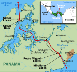
The American engineers abandoned the French plan of a sea level cut and went to a design using locks to lift ships up to the level of Gatún Lake and back down again. One of the biggest projects was the Culebra Cut through the roughest terrain on the route and remains one of the largest earth –moving projects ever tackled.

Transiting the locks

Later in the construction it was decided there would not be enough water reserves to operate the locks. Several dams were built with one being a dam at Pedro Miguel which encloses the south end of the Culebra Cut (actually an arm of Gatún Lake). The Gatun Dam is the main dam blocking the original course of the Chagres River, and resulted in creating Gatún Lake. Additionally two dams were built at Miraflores that enlarged Miraflores Lake.

Cabo San Lucas, Mexico
Mules prepare to receive a tanker
A new electric Mule

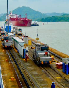
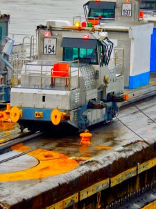
We have taken a couple of cruises that transit the canal and are always enthralled by the trip thru the locks and lakes of this remarkable place. Ships are pushed and pulled by tugs and canal rail engines called “mules” into locks with only inches of clearance. Water roars out of exhaust ports and massive ships rise and drop effortlessly within the locks.

Cruising across Lake Gatún is like a journey thru a primitive and beautiful rain forest with numerous islets. Dozens of ships glide along near us as they line up to re-enter the locks. Transiting the Culebra Cut with its walls towering above leaves us overwhelmed by the shear tonnage of dirt that had to be excavated and hauled away.

Many cruises stop at Cristobal Pier near Colon where locals offer crafts and wares for sale with usually Kuna Indians from the San Blas Islands among the merchants. Many of the cruise ships require a quick paint touch-up at the exit dock to cover up numerous rubs and scrapes from the passage through the locks

Up until recently the canal could only accommodate ships designated Panamax. Those original locks are 1,050 ft (320.04 m) in length, 110 ft (33.53 m) in width, and 41.2 ft (12.56 m) in depth. These limits have influenced the ship building industry to build Panamax vessels for the past hundred plus years

On September 7, 1977, President Jimmy Carter signed the Panama Canal Treaty and Neutrality Treaty promising to give control of the canal to the Panamanians in the year 2000. After Panama took control the Panama Canal Company started an expansion project. The expansion project started construction in 2007 and opened for commercial operation on 26 June 2016. The new locks allow transit of larger Post-Panamax and New Panamax ships, which have a greater cargo capacity than the original locks could accommodate. New Panamax ships will have a dimension of  1,200 ft (366 m) in length, 160.7 ft (49 m) in width and 49.9 ft (15.2 m) in depth. Unfortunately many of the cruise industries new mega-ships still cannot cruise the canal mainly because they are too tall to cruise under the bridge at the Pacific end of the canal.

All-in-all this is a fascinating journey and one of the three or four  best itineraries we’ve taken. The ports-of-call are an opportunity to visit a number of Central American countries and see some of this interesting region.

This is a very popular cruise itinerary, transiting the Panama Canal. Canal cruises generally cover three options. First is west to east normally starting in a California port like San Diego or LA and ending in a Florida cruise port like Miami or Ft. Lauderdale. Next there is the reverse, east to west finally some Caribbean cruises that include a trip part way through the canal returning to the Caribbean.

The Forum In Rome, The Eternal City

Rome The Eternal City

The expression goes “all roads lead to Rome” but the center of the Roman Empire was actually the Foro Romano or the Roman Forum. Rome was the center of Roman civilization for over 1,200 years from its founding in 753 BC. The Roman age went through a number of phases from the early Roman Kingdom (753 BC–509 BC) through its expansion period with the Roman Republic (509 BC–27 BC) followed after the death of Julius Caesar with the imperial Roman Empire (27 BC–476 AD) until the fall of the western empire in 476 AD.

Much of ancient Rome can still be visited in modern Rome with the center being the important Sites in the Roman Forum with a number of important buildings, statues and monuments located in the historical site.

A – Senate House: The senate house, known as the “Curia,” served as the council house of the Senate and a place for political events. It was repurposed a number of times, and was converted into a church in 655 A.D. It was on the steps of the Senate where Julius Caesar was assassinated.

B – Temple of Saturn: The first Temple of Saturn was built around 498 B.C. and is considered one of the earliest temples in the Roman Forum. The current ruins date back to roughly 42 B.C. This building was dedicated to Saturn and was also used as the treasury for Rome.

C – Arch of Titus: This arch was constructed in 81 A.D. by the Emperor Domitian for his brother, Emperor Titus, who was victorious in putting down a revolt in Jerusalem.

D – Temple of Vesta: The Temple of Vesta was a circular-shaped temple that was dedicated to Vesta, the goddess of home and family.

E – Temple of Castor and Pollux: Completed in about 484 B.C. It was dedicated to the Roman twin demi-gods, Castor and Pollux, and underwent several reconstructions.

The Rostra located near the Temple of Castor was a raised space where people could stand to make public speeches.

The Sacra Via: A pathway for ceremonial processions, this was the main road that ran through the Roman Forum and connected the various important sites. This famous street connected to the Colosseum, which was within walking distance of the central Forum.

Outside of the Roman Forum a number of sites remaining from the Roman capital can be explored that include:

Baths of Caracalla Ruin · Viale delle Terme di Caracalla are ruins of a vast Roman bath complex.

Pantheon – Piazza della Rotonda a historic Roman temple now a church.

Colosseum – Piazza del Colosseo, the iconic ancient Roman gladiatorial arena.

Circus Maximus – Via del Circo Massimo the area where a massive stone arena stood for huge scale Roman games.

Aqueduct Ruins – Via del Tritone, an ancient Roman acqueduct is still in use today.

Marcello Theater – Via del Teatro di Marcello is a Roman theater still holding summer festivals.

Walt Disney World • A History

Walt Disney was the inventor of the theme park back in 1965 with the opening of DisneyLand and the success surprised even him. Because he hadn’t anticipated just what a momentous accomplishment it was going to be he made a very serious mistake. He built Disneyland on a parcel of land in a growing urban area of Los Angeles, California. His creation had an explosive effect on property values adjacent to the park and there was no way for him to benefit from what others were building nearby or to expand the park itself.

He vowed not to let that happen again, and soon in Florida he began to secretly buy up a large tract of rural land west of Orlando. When the Disney organization was done buying land they had acquired 52 square miles of real estate, of which 47 square miles would be considered Walt Disney World. To appreciate just how big it is consider that New York’s Manhattan is less than 35 square miles. In addition to buying the land, they convinced the state of Florida to grant them a special authority. That created the Reedy Creek Improvement District which is the official governing authority of Walt Disney World. As of 2020 less than a quarter of that original land allocated to Disney World has actually been developed.

The Contemporary hotels skeleton goes up.

Walt Disney was the force behind the planning for his “Disney World” but unfortunately Walt died in late 1966 and never saw his Florida dream fulfilled. Disney World opened in 1971 with one theme park, a duplicate of DisneyLand, called the Magic Kingdom, three hotels, the Polynesian Resort, the Contemporary Resort, the Golf Resort and golf course and a campground. That was just the opening act because in less than thirty years it would explode to four theme parks, two water parks, thirty Disney owned hotels, three golf courses and 17 additional privately owned hotels.

The Contemporary with monorail tracks in front.
Monorail traveling through Epcot.

In 1975 the shopping district at Lake Buena Vista opened and in 1982 the Epcot theme park opened. In 1989 they added Disney MGM Studios (later renamed just Disney Studios) and the first water park, Typhoon Lagoon. 1998 saw the opening of the Animal Kingdom Park.

In creating DisneyLand Walt had assembled a creative team of engineers, artists, architects and designers that he called Imagineers. He soon deployed their talents to create some major pavilions for corporations at the 1964 New York Worlds Fair, which, after the fair closed were moved and installed at Disneyland.

Walt Disney also understood that transportation inside his “World” had to be highly efficient at moving large numbers of people around. From the beginning a number of interesting transportation innovations were planned. To get people from the parking lot to the Magic Kingdom a monorail system was developed along with motor launches and large ferry boats crossing the lake. There were also a number of waterways designed into the World that provided for boats to move guests.

Disney Studios Park

Walt was also an avid scale railroad enthusiast and he included an operational steam engine train as a ride at DisneyLand and Florida’s Magic Kingdom but he also installed The Fort Wilderness Railroad a 2.5 and 3.5-mile 2 ft. 6 in. narrow gauge steam-powered railroad that operated between Disney’s Fort Wilderness Resort & Campground and the River Country water park. After an operational trial period in late 1973, the railroad officially opened on January 1, 1974. After a couple of accidents, problems with track maintenance, pedestrian safety concerns, and noise issues, railroad operation was scaled back after 1977 and closed permanently in February 1980.

In Walt’s original vision for Disney World he planned to build a futuristic city called Epcot that would include residential neighborhoods, offices and shops. EPCOT stood for experimental prototype city of tomorrow. As Disney World developed, financial reality dictated that increased revenue required more attractions and the Epcot plan evolved into another theme park. The vision was changed and promoting the new park as a permanent World’s Fair, Disney management convinced a number of corporations including GE, Kodak and GM to finance pavilions. In keeping with the Worlds Fair theme Disney also promoted dedicated exhibits for a number of countries.

Animal Kingdom Park

Disney management around 1990 was testing concepts for new attractions and animal themes tested high on the surveys. That information along with the Disney brands wide involvement with animal characters and stories convinced Disney CEO Michael Eisner to explore a new animal based theme park. As the story is told, Eisner and company executives were concerned about the problems and expenses in keeping live animals and if a zoo based live animal attraction would really draw in guests.

Joe Rohde was the head of the Imagineer team developing the park and was convinced that live animals were important. To make his point one day he brought a live, 400 pound Bengal tiger into a meeting with Eisner and senior management. As Rohde gave the presentation, the tiger roamed around the room. After the experience of being eye to eye with a full-grown live tiger, Eisner agreed that live animals would be central to Disney’s Animal Kingdom.

Today in a world full of theme parks and resort hotels Walt Disney World has no equal and truly deserves the title of the happiest place on Earth.

The Grand Floridian Resort on Seven Seas Lagoon.

Hiking Yellowstone Near Old Faithful

One of the most visited areas in Yellowstone National Park surrounds The Old Faithful Lodge. There are a number of restaurants in the lodge and surrounding facilities and the largest parking areas inside the park. There are a number of trails suitable for short or extended hikes into the backcountry that begin in the Old Faithful recreation area. Here are a number of trails selected by park rangers.

Remember to carry rain gear, food and water, and other emergency equipment when hiking the backcountry trails. Be sure to check in for current trail conditions and bear activity information at the Old Faithful Visitor Education Center before starting a hike.

yellowstaone hiking maps
See larger version below to download

Observation Point

geysers in the lower basin
  • Distance, round trip: 1.6 miles or 2.2 mi
  • Difficulty: strenuous; elevation gain 160 feet (48.8 m)
  • Trailhead is behind the Old Faithful Lodge and Cabins. Walk counterclockwise around the Old Faithful boardwalk; turn right at the sign to Geyser Hill. Trailhead is on the right after the Firehole River bridge, approximately 0.3 miles from the visitor center. Switchbacks lead up the hill 0.5 miles to an incredible view of the Upper Geyser Basin. Return the same way or continue west to Solitary Geyser, which erupts frequently, then to the Geyser Hill boardwalk. The longer route is 2.2 miles.

Howard Eaton Trail

the firehole river
  • Distance, round trip: 5.8 miles
  • Difficulty: moderate
  • Trailhead: Park near the Old Faithful Ranger Station, then follow the paved path across the Grand Loop Road. Turn left at the first intersection, turn left again, and follow orange trailmarkers to the beginning of the trail. The trail climbs a burned hill, continues through spruce-fir forest, then down to Lone Star Geyser. Return the same way.

Lone Star

  • Distance, round trip: 4.8 miles
  • Difficulty: easy
  • Trailhead: 3.5 miles (5.6 km) south of Old Faithful Overpass, just beyond parking for Kepler Cascades.
  • This pleasant, partially paved trail follows an old service road beside the Firehole River to the geyser. Cyclists must dismount at the end of the asphaltand walk the last few hundred feet. Lone Star erupts up to 45 feet from from a 12-foot cone approximately every three hours.

Mallard Lake

  • Distance, round trip: 6.8 miles
  • Difficulty: moderately strenuous
  • Trailhead: Southeast side of the Old Faithful Lodge cabins, near the Firehole River. Take the first right turn as you come into the Old Faithful Lodge area and continue down the road past some cabins to the trailhead. The trail crosses the Firehole River, passes Pipeline Hot Springs, and climbs rolling hills of partially-burned lodgepole pine and open, rocky areas to the lake. Return the same way, or if you have arranged a car shuttle, continue via the Mallard Creek trail, for a total of 7.7 miles.
Old Faithful Lodge

Fairy Falls

  • Distance, round trip: 5 miles (8.4 km)
  • Difficulty: easy
  • Trailheads: Short route—park 1 mile south of Midway Geyser Basin, cross the steel bridge and walk 1.1 mile to the trailhead. Long route—park at the end of FountainFlat Dr. and walk 3 miles to the trailhead. The trail travels through young forest 1.4 miles to the 200-foot falls. Continue 0.65 miles past the falls through a wet area to Imperial Geyser, which has frequent minor eruptions.

Sentinel Meadows & Queen’s Laundry

  • Distance, round trip: 3.8 miles if you go to Queen’s Laundry
  • Difficulty: Moderate
  • Trailhead: 10 miles north of Old Faithful, turn left on Fountain Flat Drive. Park at the end of the road, cross the footbridge over the Firehole River to the trailhead. The trail follows the Firehole River a short distance, then veers toward the meadows. Look for the large sinter mounds of hot springs and the remains of the old, incomplete bathhouse.

Queen’s Laundry

  • 1.9 miles from the trailhead.
  • This trail is often very wet in spring and buggy in summer. Begun in 1881, construction was abandoned as park administrations and priorities changed. Minerals from the hot springs preserved the structure, which was the first building constructed by the government for public use in any national park. Queen’s Laundry is a National Historic Site.

Cautions: Hydrothermal areas: The thin ground in these areas breaks easily, and often overlies scalding water. Stay on the trail. All Wildlife: You must stay at least 100 yards away from bears and wolves; and at least 25 yards away from all other animals—including birds. Bears: Although your chance of an encounter is low, your safety is not guaranteed. Minimize your risks by making loud noises, shouting, or singing. Hike in groups and use caution where vision is obstructed. Carry bear spray and know how to use it. Do not hike after dark.

CLICK THIS MAP TO DOWNLOAD A pdf COPYTO PRINT OR SAVE

Taking A Walk Around Florence

There are a number of great cities well suited to urban hiking but near the top of that list is Florence, Italy.

What makes this city so special? It’s because the Enlightenment or Renaissance actually began in the early years of the fifteenth century in Florence. At the time Italy was divided into many city-states each with its own government. Florence was a city state and a Republic with a constitution which limited the power of the nobility and ensured that no one person or group could have complete political control. In fact the power resided in the hands of middle-class merchants, a few wealthy families like the Medici, important art patrons who would later rule Florence and the powerful guilds.

This unique political environment attracted intellectuals, the wealthy and artists from all over Italy and much of Europe and added to the wealth and influence of this remarkable place. Some of these notable residents included Dante Alighieri, poet, Filippo Brunelleschi, famous architect, Giotto di Bondone, painter, Michelangelo, the famous sculptor and painter of the ceiling of the Sistine Chapel, the Medici Family, Girolamo Mei, historian and humanist, Lorenzo Ghiberti, sculptor, Donatello, sculptor, Leonardo da Vinci, painter, inventor, and scientist, Niccolò Machiavelli, famous poet and philosopher, Giorgio Vasari, painter, architect, and historian and Galileo Galilei, Italian physicist, astronomer, and philosopher.

Resulting from that environment is the worlds most stunning collection of art, architecture, gardens and trade skills that survives even today.

The city is divided into two halves by the Arno River each with its own incredible attractions. The north half is home to the cathedrals, high end shopping and the train station, while the southern half is home to more museums and galleries and the incredible Piazzale Michelangelo with its amazing views of the city.

This urban hike starts at the Ponte Santa Trinita, the arched bridge over the Arno River and covers the southern city half. To walk the entire circuit will take two and a half to three hours without visiting the palaces , museums and gardens.

Begin the walk by going south from the bridge along the Via Maggio. A half block on your left is the Palazzo Frescobaldi palace and gardens. The Frescobaldi gardens, accessible through a long entrance hall, is a large grassy space with beautiful azalea bushes and an imposing fountain, an original element that has survived from the 16th century in the old courtyard. Two bronze sculptures by contemporary artist Arnaldo Pomodoro are found amongst the gardens flower beds.

In another block turn right onto Via dei Michelozzi. After a block you’ll come to Piazza Santo Spirito turn left and walk a couple of blocks along the Piazza. Piazza Santo Spirito is the main square in the Oltrarno area of Florence which is known for its artisans and street markets and has a bohemian and arty character.

Turn left at Via Mazzetta and stroll past numerous neighborhood shops and take-away food shops until you come to Piazza de Pitti and turn left.

On your right for the next several blocks you will pass the Pitti Palace. In the Palazzo Pitti are a number of art galleries, a costume museum and a modern art gallery. Tickets are required for admission to many of these famous collections. Behind the palace are huge and beautiful gardens featuring the Grotta del Buontalenti del Giardino di Boboli or the Buontalenti Grotto in the Boboli Gardens. A fascinating place, where you feel like you walked into a fairy tale. The Grotta also known as Grotta Grande or the Big Grotto was built by Bernardo Buontalenti between 1583 and 1593, and was commissioned by Francesco I de’ Medici.

The city provides excellent signage for finding sights

As you approach the river you will find yourself at a square and the entrance to the Ponte Vecchio, a medieval bridge featuring a number of jewelry and craftsmen shops. Take some time to stroll the bridge.

From the Ponte Vecchio again go south at Oltrarno, head left down Via dei Bardi and continue about three quarters of a mile. You will pass the Bardini Museum on your right with access to the Bardini Gardens. The road changes into Via di San Niccolò and takes you to the door of San Niccolò in piazza Giuseppe Poggi, which was once one of the gates to the city during Medieval times.

To your right are staircases and paths leading up from the “old door”, which now resembles more of a tower than a door. Take the steps up, cross the road past the fountain until you reach the top, where you will find a full size copy of Michelangelo’s David and an incredible view of all of Florence.

Descend through Giardino della Rose, a terraced rose garden, to the wall at Porto San Miniato and turn left on Via di Belvedero. Follow it to Porto San Giorgio where turning right you will see the Villa Bardini and its large gardens. You can walk the gardens paths back down to Costa S. Giorgio toward the Via de Guicciardini where a right turn will take you back to the Ponte Vecchio.

A 3 hour hike around some of the major attractions in Florence Italy. Visit the Pitti Palace and gardens, Piazzale Michelangelo overlooking Florence and the iconic Ponte Vecchio.


The Port of Kusadasi, Turkey

Kusadasi is a popular port of call because of its location near some of the worlds greatest ancient historical sites like Ephesus and the Temple of Artemis.

Ephesus, temple of artemis, house of the Virgin Mary