A Dozen Of The Best Florida Beaches

Get a jump on Summer and get in some serious beach time. There’s no better time for sun on the beach than Florida in the Spring with its hundreds of miles of sandy beaches lined with palm trees and lapped by crystal turquoise waters. If you’ve been dreaming about a Florida beach vacation here’s some tips on what consider.

Floridas best beaches

First, Florida is not all hot tropical weather all the time. The state has three primary temperate zones:

  • A sub-tropical zone with mostly warm winter months that includes the Florida Keys, Miami through Palm Beach on the Atlantic coast and Marco Island up to Tampa on the Gulf. High season is Winter.
  • A moderate zone with cool evenings and nights through the Winter months that stretch from the sub-tropical zone north for 50 to 100 miles on both coasts. Can at times see very cool days.
  • A mild temperate zone with a climate stretching through Northern Florida that can see average winter days in the 50° to 60° range and where frost is not uncommon. These are popular Summer beaches

The Panhandle – This piece of Florida is a popular vacation destination but its season actually runs from Spring to Autumn because of its mild temperate zone location. Also because there are no major airports nearby it is often a summer driving vacation destination for Southeastern families and Spring Breakers.

Destin

Destin Beach

A stretch of Florida coast heading east from the Alabama line that features some of the cleanest, whitest sand in the whole world, gorgeous Gulf waters and frequent sunshine. Centered on Destin this stretch of Florida coast is one of the state’s most affordable beach areas. Along with stretches of resort hotels and beach communities Destin also offers some remarkable state park beaches like June White Decker Park and Crystal Beach. Again season runs from Spring to Fall.

Panama City Beach

Panama City Beach’s 27 miles of beautiful white sand Gulf beaches offers a range of accommodations. Because of its resort vibe and wide selection of activities and restaurants it’s a popular Spring Break destination and a Summer family vacation destination.

The Treasure Coast

The best moderate Winter beaches are mostly found on the central East Coast and include wildlife refuges, long barrier island beaches, the Space Coast all within easy driving distance of Orlando.

Merritt Island

Daytona Beach

Famous for its wide expanse of white sand beach Daytona also draws Spring Break crowds, a biker week and the famous Daytona 500 race. It also has the advantage of the theme parks of Orlando only an hours drive away. If your looking for a bit more action than just lounging on the beach this city has a lot to consider.

Merritt Island

The unincorporated “town” of Merritt Island is located on Florida’s largest island and is adjacent to the Merritt Island National Wildlife Refuge and also serves as the home of NASA’s Kennedy Space Center with its launch activities and the popular Visitors Center. Located on the north end of a stretch of coast that includes Palm Bay, Melbourne, Titusville, Vero Beach and Hutchinson Islands there’s a lot to take in.

Clearwater

West Palm Beach South to Miami includes the beautiful beaches of the Fort Lauderdale area, the excitement of Miami’s South Beach and incredible diving and sport fishing.
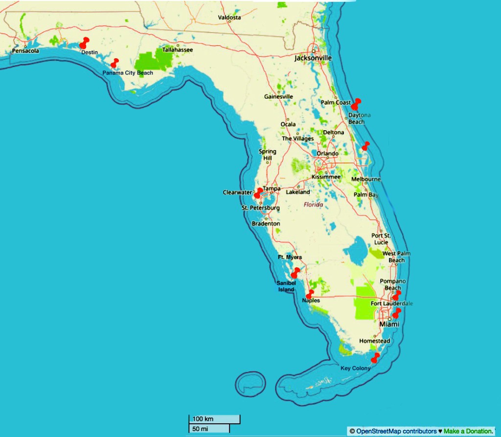
Ft. Lauderdale

Fort Lauderdale

Ft. Lauderdale

Located on a strip of land south of Boca Raton and North of Miami between the Florida Everglades and the Atlantic Ocean, it includes towns like Pompano Beach, Hollywood and Dania Beach. This area draws Winter vacationers to its warm weather, white beaches and crystal clear waters all surrounded by the excitement of a major metropolitan city.

Miami and Miami Beach

Miami Beach

This world class city has a decidedly Latin vibe with it famous South Beach, incredible resort hotels and magnificent beaches. You could spend a month here and never run out of things to do.

St. Petersburg

The Florida Keys draw boaters, sport fisherman scuba divers and snorkelers to its warm clear waters. Hundreds of islets, islands and quays (keys) stretch south from Miami to Key West but if you are looking for fantastic beaches this isn’t what you are looking for with one small exception.
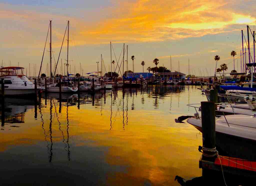
Key Colony Beach

Located just east of Marathon this small town features one of the best beaches in the Florida Keys. The beach stretches for less than a mile in front of a row of classic beach motels but you are only minutes away from the attractions of Marathon, Islamorada and about 50 miles from Key West.

Naples

Florida’s Southern Gulf Coast includes another hundred plus miles of fantastic beaches. After crossing through the Everglades from Miami on the Gulf Coast you’ll discover a number of famous islands and beach resorts. Starting in the south is Marco Island, farther north is Sanibel and Captiva and in between is the upscale beach town of Naples. Traveling north along the coast are great beaches at Sarasota, St. Petersburg, Clearwater and Dunedin along with stretches of sany barrier island beaches.

Naples

Wall to wall with golf courses, gourmet restaurants and fancy boutiques, Naples is a seriously upscale Florida beach town. While the luxury resorts and fancy restaurants can make Naples seem a bit expensive there are moderately priced accommodations to be found and luckily, the beautiful beaches are free to enjoy. Watch for the frequent dolphins swimming near the beach and visit Naples’ iconic fishing pier.

Sanibel Island

Great beaches and one of Floridas best places for shelling. Shell hunting there even has a name – the Sanibel stoop. Like its sisters, Marco and Captiva, Sanibel has a laid back feel that benefits from its sense of being off the beaten path. Perfect choices if you are trying to just get away.

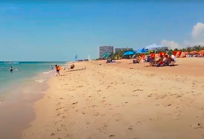
Tampa Bay Clearwater Beach

Vero Beach

Another major metropolitan center is Tampa Bay with its string of white sand beaches the area also offers major attractions like the Florida Aquarium, Busch Gardens, the Dali Museum and some of the best Sunsets anywhere. At Clearwater Beach’s Pier 60 watching a breathtaking sunset is a popular pastime. The 1,000-foot pier with its lights draws anglers here at night to fish.

When your dreams start drifting to tropical climes, remember Florida has an antidote waiting for you.

The Cruise Port of Kotor, Montenegro

The Amazing Old Port City of Kotor, Montenegro

Sailing up the Bay of Kotor is an amazing experience as it’s ringed by steep limestone mountains and surrounded by fortifications built in the Roman era through the Venetian period. It is located on the Bay of Kotor and is deep inland from the Adriatic Sea. The bay is geologically a ria, which is a filled river canyon. Together with picturesque towns, the nearly shear limestone cliffs of the mountains of Orjen and Lovćen, Kotor offers a beautifully impressive landscape.

The current population of Kotor is under 15,000 and in recent years Kotor has seen an explosion of visitors, with a majority coming by cruise ship. The cruising industry has greatly expanded in the Mediterranean requiring an more offerings for port destinations. Kotor is the newest beneficiary of this offering and with the mild environment of the Gulf of Kotor, the spectacular natural scenery and the history of the old town this is an overwhelming port of call.

Where Your Ship Docks

While there is a pier that can accommodate smaller cruise ships most larger cruise ships anchor out making this normally a tender port. The good news is because of the protection of the mountains the waters are usually very calm. The pier and tender landing is the focus of a visitors center, tour buses and the Old Town of Kotor is only a short walk away. While there aren’t any public facilities at the port there are some in the old city along with a number of cafes and restaurants.

Transportation

Because of the rugged mountains that ring the area the town is somewhat isolated but it has ferries and limited train service. Some cruise ships offer a free shuttle service from the ship to the Old City but since it is only an easy and short walk it really isn’t necessary.

Bus Service – There are usually sightseeing buses operating out of the port when cruise ships are visiting.

Local Currency

The currency in Kotor is the Euro (€). You can also readily find ATM’s in the city and most major credit cards are welcome.The local language is Montenegrin, but most people speak English.

Things To See And Do In Kotor

St. Tryphon Cathedral: This beautiful cathedral dates back to the 12th century and is a must-visit attraction in Kotor.

Kotor Fortress: The hike up to the top of the fortress is challenging, but the views of Kotor Bay from the top are absolutely breathtaking.

Maritime Museum: This museum showcases the rich maritime history of Kotor and Montenegro.

Boka Bay Cruise: It the body of water in front of old historic Kotor – take a boat tour of the stunning Boka Bay and enjoy the picturesque scenery.

Lovcen National Park: This national park is located just outside of Kotor and offers hiking trails, stunning views, and a chance to see Montenegro’s natural beauty.

Lady of Remedy Church: Sitting far above the old town is the Lady of Remedy, along with the Byzantine Fort St. Ivan and the Chapel of St. John. The Lady of Remedy is a Roman Catholic church belonging to the Catholic Diocese of Kotor and dates from 1518. The church is perched on the steep slope of the St. John Mountain with a commanding view of the Old Town below. If you are in good shape you should consider taking the hike up the mountain over the stairs and trail cut into the rock of the mountain. The road (walking path) ascends from behind the Church of St. Mary Collegiate in the back of the old town.

The town of Kotor is part of a World Heritage Site named the Natural and Culturo-Historical Region of Kotor. The fortified city of Kotor was also included in UNESCO’s World Heritage Site list as part of “the Venetian Works of Defense between 15th and 17th centuries”.

The Lady of the Rocks: A small artificial island located in the Bay of Kotor in Montenegro. According to legend, the island was created over 500 years ago by two brothers who found an icon of the Virgin Mary and decided to build a church on the spot where they found it.

Over time, sailors passing by would throw rocks into the water near the island as a way of asking for safe passage. Eventually, the island grew larger and larger as more rocks were added. Today, the Lady of the Rocks is home to a beautiful church and museum, which houses a collection of silver votive tablets and other artifacts.

Every year on July 22, locals celebrate the feast day of the Lady of the Rocks with a procession and boat race. The island is also a popular tourist destination, with visitors coming from all over to see the stunning views of the Bay of Kotor and to learn about the fascinating history of this unique island.

History of Kotor

The town was first mentioned in Roman writings around 168 BC, and was known as Acruvium, and was part of the Roman province of Dalmatia.

The area has been fortified since the Middle Ages, when Emperor Justinian erected a fortress above Ascrivium in 535 AD, after expelling the Ostrogoths. Ascrivium was later sacked by the Saracens in 840. It was fortified with walls and castle near the peak of Saint Ivan by Constantine VII in the 10th century. It was one of the more influential Dalmatian city-states throughout the early Middle Ages.The city was part of Byzantine Dalmatia in that period, and the modern name of Kotor probably originated from its Byzantine name.

Wines of Montenegro

In Montenegro, grapes have been grown for over two thousands years and the Romans brought wine making to the region. With a perfect climate for vineyards, wine making has flourished in the region with two varietals of special note– dark “Vranac” and bright “Krsta?”. These wines are named for these grapes.


Looking For A Hotdog in Vienna

Street Food Is Sometimes A Good Option

We became”pen pals” with an Austrian couple after traveling with them a while back. In one of many e-mail exchanges, we told them we would be visiting Vienna which prompted them to send us a list of things to do while there. High on the list was a hot dog stand behind the State Opera House. Being too intriguing to pass up, as soon as we got into the center of Vienna, with cell phone in hand to navigate, we headed off in search of Bitzingers, the famous hotdog stand.

Arriving shortly after noon there was a line already formed. The customer directly in front of us was a member of the Polizei, the Austrian police. He provided inspiration for our selection choice as the proprietor was filling a carry away bag with a large number of different varieties of hot dogs/sausages/toppings.

Being unable to read the German menu, when it was our turn we very simply asked for two hot dogs, one plain and one with mustard. The preparation process involves having an end sliced, at an angle from what can best be described as a small baguette. The baguette is then pushed down on a stainless spike to make a hole for the hotdog. A squirt of mustard goes into the hole followed by a really good hotdog and then wrapped by a square of foil.

Simple, fast and remarkably tasty. Sometimes following the advice of locals is the best bet. Later while walking around Vienna we passed a couple of other Bitzingers stands, so this isn’t a one-off operation. However, most new visitors to this city are drown to the city center with its palaces, museums, cathedrals and blocks of shops and cafes. Knowing the downtown location of Bitzingers could come in handy. It is right behind the State Opera House which is an easy landmark to navigate towards. Also within a few blocks of the Opera House quick a search on your phone with Google Maps should provide a precise directions.

Protecting Your Home While Away?

There’s good news and bad news about home security today. The bad news is that crime is up and very few neighborhoods are immune. The good news is that there are whole collections of security devices and enhancements today to help protect your home while you’re away.

Here The Intentional Travelers offer a comprehensive list of things to help secure your home on a reasonable budget. We’ll start with door locks.

Door Locks

Make sure your locks and keys are sufficient to protect from forced entry. When selecting house door locks, several factors contribute to their effectiveness and security. Here are some key aspects to consider:

1. Lock Type:

  • Deadbolts: These are the most secure type of locks and should be installed on all exterior doors. They have a solid metal bolt that extends into the door frame, making them resistant to forced entry.
  • Knob Locks: These are less secure than deadbolts but are commonly used for interior doors. They have a locking mechanism built into the doorknob.
  • Smart Locks: These locks use electronic mechanisms and can be controlled remotely using a smartphone or other devices. While convenient, they may be more susceptible to hacking if not properly secured.

2. Lock Material:

  • Solid Metal: Locks made of solid metal, such as brass or stainless steel, are more durable and resistant to tampering compared to locks made of weaker materials like plastic or aluminum.

3. Strike Plate:

  • The strike plate is the metal plate attached to the door frame where the lock bolt enters. It should be securely fastened with long screws to prevent the door from being forced open.

4. Keyway:

  • Look for locks with a narrow keyway, as it makes it more difficult for someone to insert and manipulate tools to pick the lock.

5. Bump-Proof:

  • Consider locks that are bump-proof or resistant to lock bumping, a technique where a key is rapidly inserted, tapped and turned to disengage the locking mechanism.

6. Key Control:

  • Keep track of your keys and avoid making duplicate keys that could fall into the wrong hands.

7. Door Reinforcement:

  • In addition to a strong lock, ensure that the door itself is sturdy and reinforced to prevent forced entry.

8. Door Chains or Security Bars:

• These devices provide an additional layer of security by preventing the door from being opened beyond a certain point, even if the lock is compromised.

Remember, the best security often comes from a combination of different measures, including locks, door reinforcement, window protection and security systems. If you’re unsure about choosing the right locks for your home, talk to your local hardware store or consult with a professional locksmith.

Secure Windows

Protecting your house windows from potential damage is crucial for maintaining the security and aesthetics of your home. Here are some comprehensive tips to help you safeguard your windows:

  1. Window Security Film: Apply a transparent security film to the interior of your windows. This film helps hold the glass together in case of breakage, preventing shattering and making it more difficult for intruders to gain entry.
  2. Window Bars: Install metal bars or grilles over your windows, especially those on the ground floor or in vulnerable areas. These bars act as a physical barrier, deterring burglars and providing an additional layer of security.
  3. Reinforced Glass: Consider replacing your existing windows with reinforced or laminated glass. These types of glass are more resistant to breaking and can withstand significant force.
  4. Window Locks: Ensure that all your windows have sturdy locks that are difficult to manipulate from the outside. Invest in high-quality locks and keep them well-maintained.
  5. Smart Home Devices: Install smart home devices like motion sensors or glass break sensors near your windows. These devices can alert you or the authorities in case of any suspicious activity or attempted break-ins.
  6. Trim Vegetation: Keep trees and shrubs trimmed away from your windows. Overgrown vegetation can provide cover for burglars and make it easier for them to access your windows.
  7. Curtains and Blinds: Keep your curtains or blinds closed when you’re away from home or at night. This reduces visibility into your home and discourages potential intruders.
  8. Window Alarms: Consider installing window alarms that can trigger a loud noise or send an alert to your smartphone when a window is opened unexpectedly.
  9. Security Cameras: Place security cameras near your windows to deter burglars and capture any suspicious activity.
  10. Home Security System: If possible, invest in a comprehensive home security system that includes window sensors and motion detectors. This can provide an additional layer of protection for your entire home.

Securing your garage

One area of home vulnerability often overlooked is the garage door. There have also been stories of electronic devices that can capture the signal from a garage door opener or can transmit a series of signals looking for the code. To safeguard against that while traveling today most garage doors have a set of interior bolts that secure the door and prevent it from opening. Another easy way of further securing your garage door is to unplug the motor.

Doorbell Cameras

Ring doorbells are a popular home security device that can help deter crime and keep your home safe. They work by sending a live video feed of your front door to your smartphone or tablet, so you can see who’s there even when you’re not home. Ring doorbells also have a built-in speaker and microphone, so you can talk to visitors and let them know you’re home.

There are many different models of Ring doorbells available, so you can find one that fits your needs and budget. Some models even have additional features, such as motion detection, night vision, and facial recognition.

Ring doorbells are a great way to improve the security of your home. They’re easy to install and use, and they can provide you with peace of mind knowing that you can always see who’s at your door.

Here are some of the benefits of Ring doorbells:

  • They deter crime by making it more difficult for burglars to break into your home.
  • They allow you to see who’s at your door even when you’re not home.
  • They let you talk to visitors and let them know you’re home.
  • They can help you keep an eye on your property and your loved ones.
  • They’re easy to install and use.
  • They’re affordable.

If you’re looking for a way to improve the security of your home, a Ring doorbell is a popular option.

Shop for Ring Doorbells on Amazon HERE.

An Alarm System

Our choice is one we installed several years ago. We installed a SimplySafe system eight years ago for less than $200 (the basic system is now $289 and includes 3 door/window sensors, 1 room motion detector, an interior keypad and a base station). There are a number of packages available with additions that include breaking glass detector, a leak detector, a wireless key fob and outdoor security devices. The system can be monitored for $30 a month (no contract – start and stop anytime) and includes a phone app that allows you to arm, disarm and monitor it remotely.

The SimplySafe alarm system has received mostly positive reviews from consumers, who praise its ease of use, reliability, and affordability. Overall, the SimplySafe alarm system is a good choice for homeowners who are looking for a reliable and affordable home security system on a budget.

Positives Include:

  • Easy to use and install
  • Reliable
  • Affordable
  • Variety of features
  • Mobile app control and monitoring
  • Professional monitoring option ($30 month with no contract)

Shop SimplySafe alarms on Amazon HERE.

DIY Travel Pin Maps! Free!

Our own travel pin map

What, you don’t have a pin map? Well, let’s fix that…

We’ve been overwhelmed by the response to this offer and we want to make sure that everyone has an opportunity to get our FREE Travel Pin Map!

If you love travel, keeping a travel pin map is a great way to keep track of where you’ve been while also a fantastic decorating accent. We started ours years ago and even today it is a fantastic conversation piece.

Years ago we started getting requests from family and friends to make one for them. It became a favorite gift item and after a few dozen maps we decided we’d try selling them online.

We started selling on Etsy with a few world map color versions and added a United States map. We offered a selection of titles and provided personalization included (all our friends and relatives wanted theirs personalized). Within a couple of months sales took off and soon I was spending hours printing and shipping maps. A few dozen a week wasn’t going to make me rich but it was eating up a lot of my week. After about six months I shut it down because it was just too much work…

After a lot of prodding we’ve decided to put in some more time exploring our travel pin maps again. After talking to a number of friends about the process and discussing options we’ve started developing a plan.

This time we’re using a do-it-yourself approach and if you follow our steps you’ll have a decorating accent to be proud of!

Making Your Custom Travel Pin Map

Here’s how to create your very own custom 16×20″ pin map for under US$50 in five simple steps:

  • Get our pin map at Etsy HERE* (Please note that for a few of weeks our Etsy shop is on vacation – so we’re making our visitors a special limited time offer*.

*While we are traveling you can download our pin map for FREE instead of buying it on Etsy.

  • Print it up to 16×20″ At Walmart or Office Depot
  • Pick out a standard 16×20 frame
  • Remove glass in frame and back up with a sheet of foam board
  • Get a set of map push pins

Do It Yourself  Instructions For Our Travel Pin Map

Download Our Map And Make It Your Own

Customizing Your Map

Microsoft

Microsoft offers several software tools and services that can be used for annotating our JPG map file that include:

Our files are formatted in a 4:5 ratio that will produce prints from 4×5” through 16×20” and are provided in an open jpg file format that can be customized using many standard applications in computers using MS, Apple and Google operating systems by following the steps outlined here.

• Microsoft Paint: A basic image editing program included with Windows that allows users to add simple annotations such as text, lines, and shapes to images.

• Microsoft Office Picture Manager: A more advanced image editing program that comes with Microsoft Office and provides more features for annotating images, including the ability to add captions, watermarks, and other effects.

• Microsoft OneNote: A digital note-taking application that allows users to insert and annotate images, including JPG files.

• Microsoft SharePoint: A cloud-based collaboration platform that allows users to store, share, and annotate images, in JPG files.

Apple Macintosh

Using the Preview application:

• Open the JPG image in Preview.

• Click the “Markup Toolbar” button in the toolbar.

• Select the annotation tool you want to use, such as the “Text” tool, “Shape” tool, or “Arrow” tool.

• Click and drag on the image to create your annotation.

• Adjust the properties of the annotation, such as font, color, and size, using the options in the Markup Toolbar.

• Save the finished file for printing.

Google Operating Systems

With a Google computer using Google Cloud, This system offers a comprehensive platform for image annotation. It provides a suite of tools and services that enable users to annotate JPG images efficiently and accurately providing powerful image editing tools that facilitate the annotation process. Users can easily draw bounding boxes around objects, add polygons, or even create 3D annotations. These tools ensure precise and consistent annotation, which is essential for high-quality machine learning models.

Printing Your Map

If you have access to a printer that can print to a sheet size of 13×19 you can print your map yourself at either 11×14 (standard frame size) or use 13×19 paper trimmed to 13×16.

Large prints can be ordered from a number of sites including Office Depot and Walmart. If you have a wide format (13×19) you can of course print it yourself.

Print yours with Walmart Custom Prints. The 16×20” print is the best format at under $14.00 and the order can be placed with your local Walmart online at the web page below.

Click Walmart Link HERE

Framing Your Map

Our maps when printed can be formatted to fit a 16×20” standard size frame, or 11×14”, 8.5×11” and 8×10”that are available nationwide from many stores like Michaels or Walmart as well as online. In order to convert the frame to a pin map all need to do is to remove the plastic or glass front, back up the map with a sheet of foam board and reassemble. See a good choice from Michaels HERE.

Pushpins

Hopefully you’ll be adding a lot of pins to your map and while you can find push pins in most office supply departments we recommend a smaller headed shorter pin made for that purpose and recommend Yalis Push Pins 600-count Map Tacks available from Amazon HERE.

Getting Around Budapest

Click the map above to download our pdf Budapest Visitor’s Map re-imagined  to get you to the major attractions using public transportation.

The first problem trying to get around in Budapest is the Hungarian language. While many Hungarians speak English you will find few maps, signs or streets in anything but Hungarian. If you follow the tips here you will quickly get the hang of navigating through this city and its public transportation. 

Budapest is a remarkable, beautiful and large city with the Danube River running thru the middle of it. Along the river in the central city are four major bridges. Starting from the north at the southern tip of Margit Island is Margit Bridge.

Hungarian Parliament Building

Margit hid or Margaret Bridge is a bridge carrying trams, cars and pedestrians connecting Buda and Pest along with access to Margaret Island. It was designed by French engineer Ernest Goüin and built by the construction company Maison Ernest Goüin et Cie. between 1872 and 1876. Margaret Bridge was the second permanent bridge in Budapest.

Next is the Széchenyi Chain Bridge. Designed by the English engineer William Tierney Clark and built by the Scottish engineer Adam Clark, it was the first permanent bridge across the Danube in Hungary. It was opened in 1849.

Next is Elisabeth Bridge (Hungarian: Erzsébet híd) is the third newest bridge of Budapest. The bridge is situated at the narrowest part of the Danube in the Budapest area, spanning only 290 m. It is named after Elisabeth of Bavaria, a popular queen and empress but often referred to by locals as the “White Bridge”.

Going south the fourth bridge is Szabadság híd (in English it means Liberty Bridge or Freedom Bridge. It was originally named Ferenc József híd (Franz Joseph Bridge). At its two ends are two public squares, Gellért tér, at the foot of Gellért Hill, next to the Gellért Spa and Fővám tér at the Great Market Hall. Built as part of the Millennium World Exhibition at the end of the 19th century, the bridge features art nouveau design and mythological sculptures.

Station on the Budapest subway

Navigating the city by surface streets can be confusing with neighborhood streets seeming laid out like a maze. Many areas have very few streets that are laid out in a square grid pattern but rather seem to zig zag back and forth. For this reason even trying to use a street map for navigation can be frustrating if you are walking. If you are walking to destinations we recommend using a cell phone for navigation. Fortunately major tram routes and subways trace prominent paths thru the city and stops are mostly found at major intersections.

Budapest has a very efficient and inexpensive metropolitan transit system. The best option if you are going to be spending a couple of days in this city, is to get a Metro “day pass” which averages about $6.00 per person per day or less and is available in one, two and three day passes. A day pass operates on a 24-hour cycle so if you buy one at 10:00 am it can be used until 10:00 am the next day. You can purchase them from vending machines but our recommendation is to purchase them from a manned ticket window open during business hours at most major stations. These are usually at major street intersections where you will find there are stairs going underground that are often also the best way to cross large city streets. While an amazing number of Hungarians know a passing amount of English, signage is another story in this city. Finding good signage in English is actually very rare in Budapest. Beside being able to talk to an agent about purchasing the best pass for your needs, they will also give you a complete set of pocket maps with some information brochures in English that are not available at the machines. The metro system is based on individual tickets based on tapping onto trams and busses. If you buy a day pass you do not need to tap on or off the various transports but simply have the passes with you. The truth is that after three or four days of riding rapid transit, nobody ever asked to see our pass.

Tram stop on the Route 4 line

One exception to that was one day we bought a train ticket for an hour trip out to Slovakia which offered a partial discount off the price if we had an active transit pass. The conductor on the train did want to see our metro pass to confirm that we were entitled to the reduced train fare.

Metropolitan transit in Budapest has three primary systems. They are subways, buses and the street trams. The easiest to navigate are the surface trams which are clearly marked on maps by their routes. They also have the advantage of being operated at street level where you can see where you are.

As a visitor think about Budapest as being divided up into several areas of interest. First the city is divided by the Danube River. The east side of the river is the old city of Buda with most areas of interest located within a mile of the river. Much of this terrain is steeply inclined up to the fortifications, the castle and Matthias Church and the old city. There is also a funicular that goes up to the castle level from near the Fisherman’s Bastion.

The west side of the river is the old city of Pest and includes most of the large commercial areas and additional major attractions. Some major sights include St. Stephen’s Basilica, The Hungarian Parliament Building, Hero’s Square as well as a number of major museums and galleries.

There are two primary tram lines designated 4 and 6 inside the central city that cross the river at the Margit bridge and the Erzebet Bridge. These two lines are major routes for people to use going to work and shopping and can get busy at times. Along these routes are the Central Train Station, the Market Hall, the New York Cafe and the Octagon intersection. From Octagon you can switch to the #1 subway line to get to Hero’s Square, the National Museum and or toward the river to the Opera House and a popular restaurant neighborhood.

There is an intersection of tram routes 4 and 6 with the #4 subway line at Jozsef Krt and Rakoczi Ut where you can switch routes and take the subway toward the Danube..

The easiest way we found to use the trams and subways is to know the map location where you get on and count the number of stops to where you are going, Understanding the Hungarian tram and subway announcements is often difficult and reading stop locations can be a challenge. Also station names at the various stations in the subway are poorly marked. For example boarding a west bound subway at the Octagon station and wanting to get off at Heroes Square to visit the gardens simply count five station stops.

After just a couple of trips you will easily get the hang of the system. Rush hour is also an interesting time on the trams. When the doors open on a packed full tram you will quickly realize that the crowd behind you believes there is plenty of room for a number of additional riders inside. You may be reluctant to push in but the next thing you know you are right there, packed into the car that you thought you wouldn’t fit into. Don’t worry most everyone is friendly and accommodating. Also if you aren’t sure where you are ask for help. We rarely found anyone that couldn’t understand some English and were happy to help.