The circus still lives on – not a modern Cirque du Soleil, but an old fashion Ringling Bros. and Barnum & Bailey Circus style extravaganza! It is appropriately located in America’s circus home town, Sarasota, Florida.
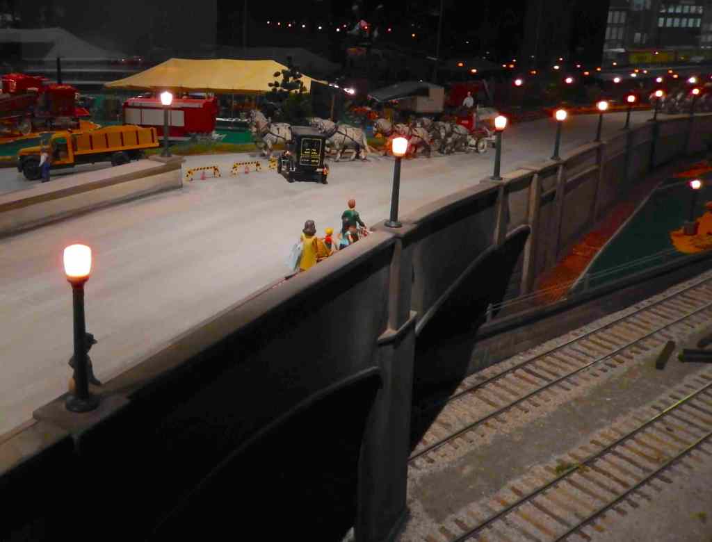
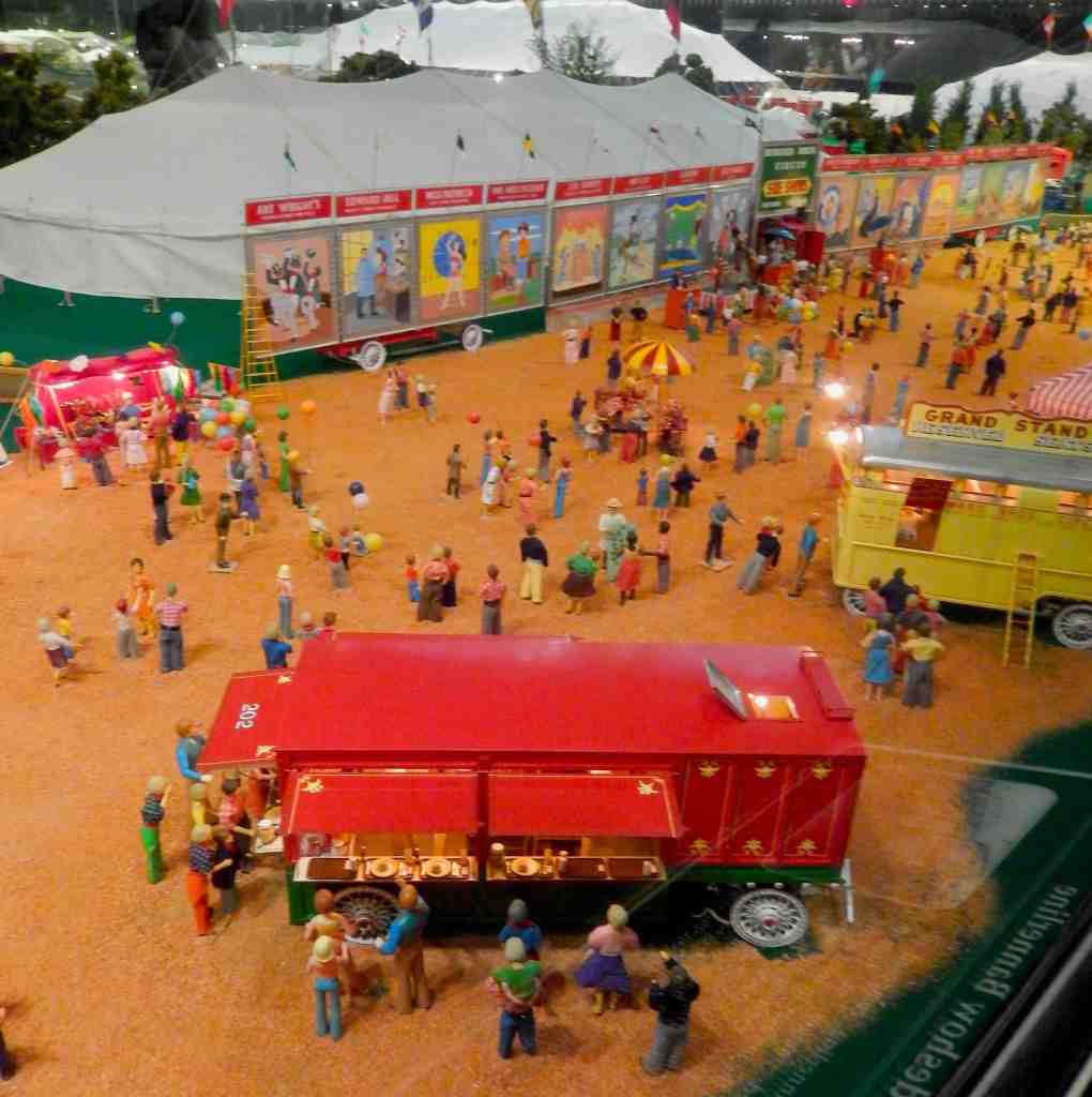
The Amazing Howard Bros. Circus is a ¾-inch-to-the-foot scale replica of Ringling Bros. and Barnum & Bailey Circus located on the Ringling Estate in Sarasota, Florida. It includes a complete reproduction of the entire circus as it existed in the 1920s).
Howard C. Tibbals asked Ringling management if he could use their name for his circus when he started building it, but they refused. So he called it The Howard Bros. Circus instead. There never was a full-scale Howard Brother’s Circus.
Tibbals began toying with circuses in 1943, at the age of 7. At 12 he was given a lathe and jigsaw, which greatly advanced his model building and Tibbals started working on the model in earnest in 1956. Much of the circus was completed by 1974, but it did not premiere until the 1982 World Fair in Knoxville, TN. In 2004, Tibbals set up the Circus at its current location in the Ringling Estate’s Tibbals Learning Center, which includes a full-scale replica of Tibbals’s workshop. It took Tibbals over one year to set up the circus in its current location.
There are many stories in Irish Mythology of adventures, grudges, voyages, battles and gods and a key character in many of the early tales is the mythical Irish hero Fionn MacCool and his warriors of the Fianna. These were forest-dwelling warriors often referred to in myths dating back to the 3rd Century AD as the soldiers of destiny. Fionn Macumhaill (Finn McCool) was a chieftain in medieval Ireland. With his adventures documented in the Fenian Tales, said to have been recorded as poems by Finn McCool’s son, Oisín, and told and retold by the Irish people for centuries.
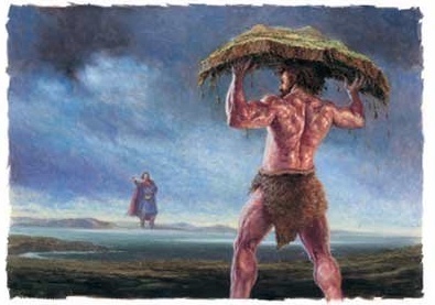
The legend says Finn McCool was a giant of a man and across the waters in Scotland was another giant named Benandonner, also known as the Red Man. Finn McCool and the Red Man exchanged insults from a distance and eventually Mac challenged this Scottish giant to a fight.
According to Irish legend, the Red man accepted the challenge and these two giants began building a causeway across the sea so they could fight. In one version of the story, Finn defeats Benandonner but in another, McCool hides from Benandonner after he realizes that the Red Man is much bigger than he is. To save him Finn’s wife, Oonagh, disguises him as a baby and tucks him into a giant cradle. When Benandonner sees the size of the “baby” he realizes that its father, Finn, must be a giant among giants. He flees back to Scotland in fright, destroying the causeway. Remnants of the causeway are found today at Fingal’s Cave on the Scottish isle of Staffa and The Giants Causeway in Northern Ireland adding confirmation to the legend.
The Giants Causeway – Up on the rugged coast of Northern Ireland about two hours north of Belfast is a geological wonder and a World Heritage Site named The Giants Causeway. The unusual formation was born of natural processes 65 million years ago, when Northern Ireland was subjected to major volcanic activity. During this period, molten basalt came into contact with chalk beds, forming a lava plateau. In this circumstance, the lava cracks and fractures. Cracks opening along the cooling surface get propagated downward, resulting in the long, well-defined columns known as columnar basalt. Some believe water like rain, lakes, or oceans play a role in the cooling and fracturing process. At The Giants Causeway the lava cooled, the plateau contracted and cracked, forming about 40,000 similar sized hexagonal columns of varying heights that look like giant stepping stones. The largest pilers stand over 35 feet tall.
The Giants Causeway and the other end of the formation in Scotland aren’t the only places you’ll find these unusual basalt columns around the world. They include;
Hexagon pool, Golan, Israel
The Cliff of Stone Plates – Ghenh Da Dia in Vietnam
Prismas Basalticos in Huasca de Ocampo, Hidalgo, Mexico
Akun island columnar basalt, Alaska
The Gangolfsberg, Rhön, Bavaria, Germany
Froðba, Faroe Islands
Columnar Basalt in High Island Reservoir, Hong Kong
The Devil’s Postpile in California
Symphony of Stones at Garni Gorge, Armenia
Hexagon pool, Golan, Israel
The site of the Giants Causeway is spectacular and includes a good visitors center, a well paved road down to the Causeway, a shuttle bus and a number of food and refreshment venues around the site that include the Causeway Inn with a cozy bar.
The ruins of Dunluce Castle, where a number of Game of Thrones episodes were filmed, are also not far from The Giants Causeway site.
Navigating on our cellphones is great but it does have shortcomings. Over the years we’ve collected a number of maps and marked them up with attractions and routes to follow. We have also combined and modified maps before our trip to simplify understanding a place. Here we provide a number of these modified maps that cover major cities, a number of metro transit systems, parks and hiking trails. They’re easy to download and print (pdf files) to help with your plans. Click on each map to set-up the download.
Seeing Budapest using public transportation – Budapest is a wonderful city with a remarkable public transportation system. Modern light rail and subways can take you all around the city.
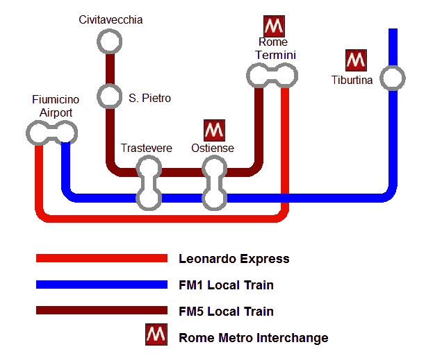
The Trains of Metro Rome Rome is a large metropolitan area with commuter trains servicing the international airport, the historic center and the seaport of Civitavecchia. Using public transportation can save time and money.
Bus routes on Maui, Hawaii – This island has an incredible public bus system that will take you around the whole island (no service through the National Park).
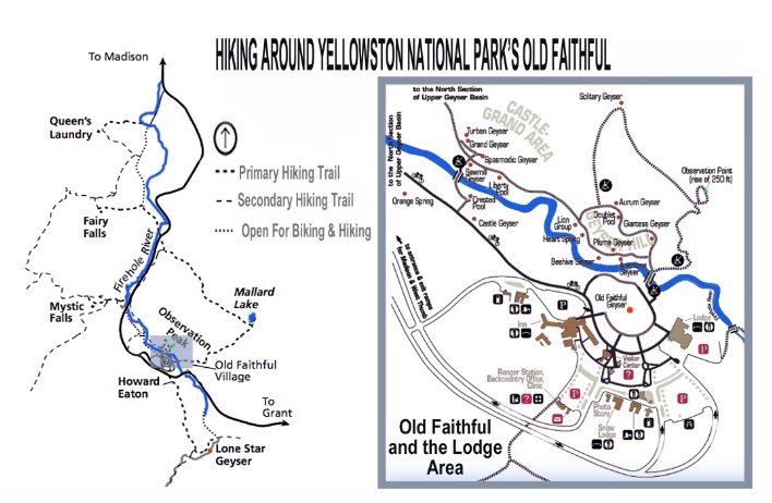
Hiking Trails Near Old Faithful – A favorite destination in Yellowstone the area around Old Faithful Lodge has a number of fantastic hiking trails.
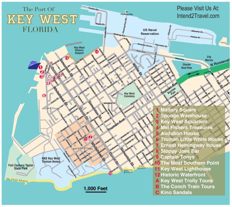
Key West Florida is an American original – Easy to get around on foot with the heart of this town being a joy to explore.
Public transportation Sydney Australia – A fantastic, modern city with a great public transportation system that includes regional trains, light rail and a fleet of ferries.
Driving Oahu and seeing the attractions – Oahu is an island you need to drive around to really see. Also there are a couple of worthwhile bus routes that service Honolulu and the Pearl Harbor area.
Walking tour of Florence – City walking tours are all the rage and this one lays out a self-guided tour of this city south of the Arno River.
Rome’s Metro System – A simplified guide to Rome’s Metro system from the port of Civitavecchia to the International Airport.
The Forum in Rome – A 3D map of this ancient Roman site.
One day tour of Rome – A guide to hitting the major attractions in Rome with just 8 hours on your own.
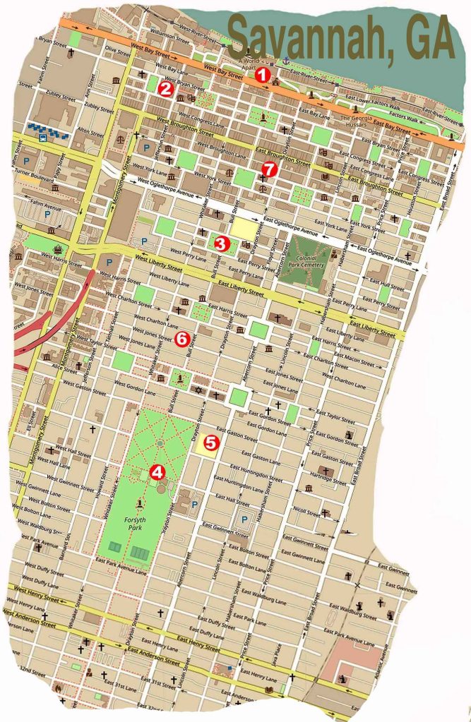
Savannah Georgia is one of America’s great cities and perfect for seeing on foot. This map as a quick pocket reference on what to see and how to get there.
Paris Metro – a simplified guide – The Paris Metro is world renowned and here we offer a simplified system map focused on the main tourist destinations.
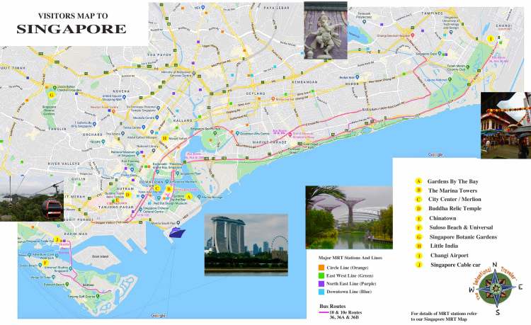
Singapore Metro Map – Inexpensive, incredibly clean and efficient, this city’s metro is one of the best in the world.
Disney World Transportation Systems– Larger than New York’s Manhattan the Disney people have provided an efficient system to get you around that incorporates buses, boats, monorails and cable cars.
Tourist Guide to Singapore bus routes – In addition to the Metro there is a modern fleet of mostly double-decker buses that can take you around the central city, along the coastal Marine Parade area to the airport.
The Trails of Iguazu Falls Argentina This park has over 30 miles of trails and it’s important to know which ones are the most spectacular to help get the most from your visit.
The New York subways are a fast way to see Manhattan and this map eliminates everything but the Manhattan stops and the locations of major attractions.
Yellowstone National Park is the size of the state of Delaware and you need a plan before you get there. Here are 5 major attractions along with key driving routes.
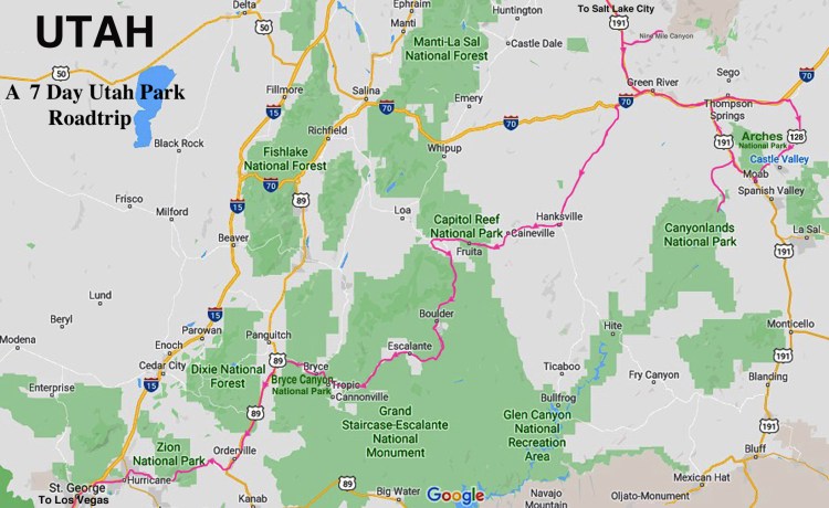
Utah Driving Park Tour – Utah has the countries largest collections of National Parks along with some great state parks. This map is a guide to driving Utah to see the national Parks.
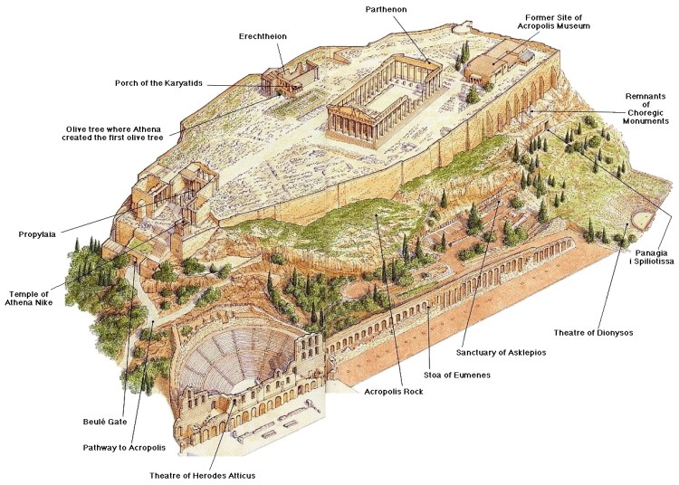
The Acropolis in Athens – A 3D map of this ancient site.
Mendenhall Glacier – Hiking trails around the glacier and the glacial lake.
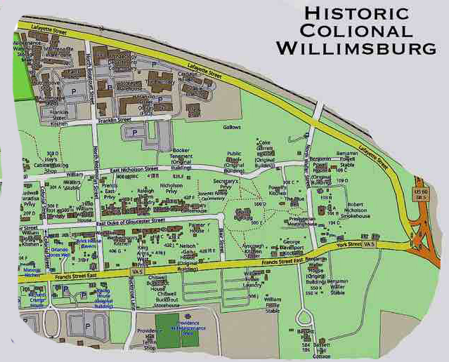
Historic Williamsburg is a must visit if you’re an American history enthusiast. This map is a great guide to seeing the historic district.
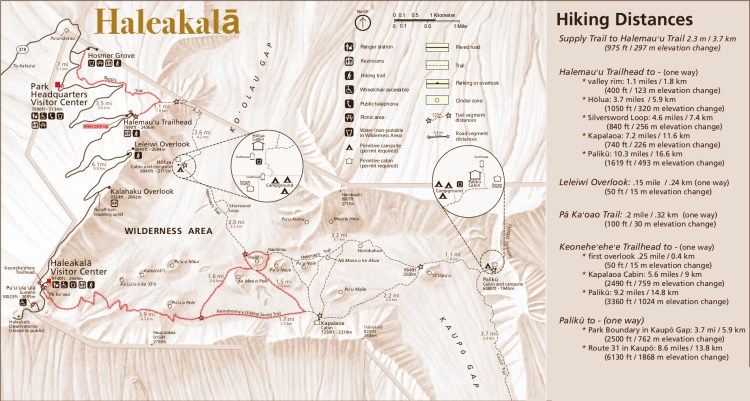
HikingHaleakalāNational Park – Hiking trails on Maui’s great volcano.
Amsterdam has a great transit system and getting familiar with it is a great way to get a head start on seeing the city. Be sure and get multi-day tickets.
Hong Kong has one the world’s best metro systems. Plan your day ahead of time while you familiarize yourself with the city.
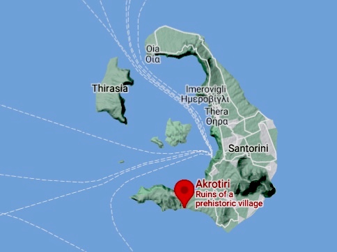
The Canary Islands, a Spanish volcanic archipelago less than 100 miles off the coast of northwestern Africa. They are known for their black- and white-sand beaches and rugged terrain. Tenerife, the largest island and most populated of the archipelago, is dominated by the sometimes-snowy active volcano Mt. Teide. Immediately east of Tenerife is Gran Canaria, an equally popular European vacation destination.
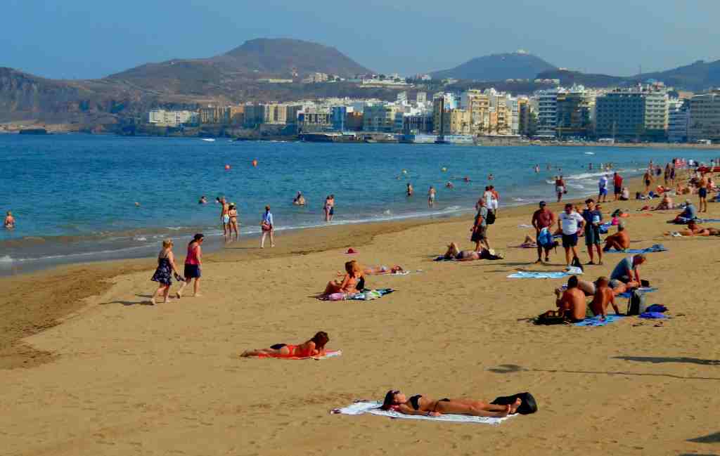
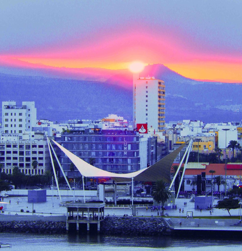
Las Palmas de Gran Canaria is popular for enjoying one of the worlds best climates and miles of beautiful beaches. It also boasts important historical and cultural heritage sites, centered in the district of Vegueta, the oldest quarter of Las Palmas, which was declared a UNESCO World Heritage Site in 1990.
Where Your Ship Docks
The Las Palmas cruise ship piers are located right in the commercial center of the city which allows easy walking out. There are some public facilities at the pier and in the adjacent mall. Walking into town is less than a quarter of a mile. Right at the entry to the port is a modern five-story shopping mall which is very convenient for picking up some necessities and last minute souvenirs.
Las Palmas Mall
Getting Around
The island has a good public bus system. Around the island the buses are operated by the company Global, with routes all over the island. In Las Palmas de Gran Canaria, you can use the local city buses.
The city also features Hop-On Hop-Off tour buses at about US$25. The No.1 stop is Santa Catalina Park, a perfect place to begin and not too far from the pier. The bus will carry you to 11 locations in the city.
Attractions
Playa de las Canteras – Las Palmas is now one of Europe’s most popular beach destinations with almost 2 miles of magnificent yellow sand it is considered one of the world’s best in-city beaches. This attractive seaside promenade – the Paseo de las Canteras, allows walkers and joggers to enjoy the entire length of the beach. If you’re a snorkeler there is an incredible reef, called La Barra, which at low tide turns the waters of Las Canteras into a giant snorkeling pool.
Playa de Alcaravaneras. Taking a stroll through Triana – the city’s central pedestrian shopping area in the city’s historic center. There are lots of high end shops and boutiques, side streets laden with cafes and great places for tapas and drinks. Walk along the Paseo de Las Canteras promenade, situated along Las Palmas de Gran Canaria’s premier beach – Playa de las Canteras. Take a moment to sit and enjoy a coffee or an ice cream from one of many cafes.
Also the Avenida Marítima connects with the pretty fishing village of San Cristóbal, arguably the best place for seafood in Las Palmas de Gran Canaria.
Casa-Museo de Colón. This fascinating museum documents Columbus’ voyages and features exhibits on the Canary Islands.
Catedral de Santa Ana – The religious center of the city, this neoclassical cathedral was begun in the 15th century after the Spanish conquest, but wasn’t complete until the 1800’s. The lofty columns that match the majestic palm trees of the island. It also features paintings by Juan de Miranda, the Canary Islands’ most-respected 18th-century artist.
Las Palmas de Gran Canaria is home to the Pueblo Canario, a facsimile of a traditional Canarian village in the heart of the capital. There are free live performances of Canarian folk music every Thursday afternoon and Sunday morning which you can watch from the comfort of a table on the outdoor terrace. It is also the location of the Museo Néstor, one of the city’s art galleries.
For additional information one of the best, in depth, online guides to the Canary Islands is located HERE.
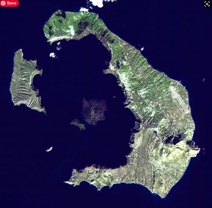
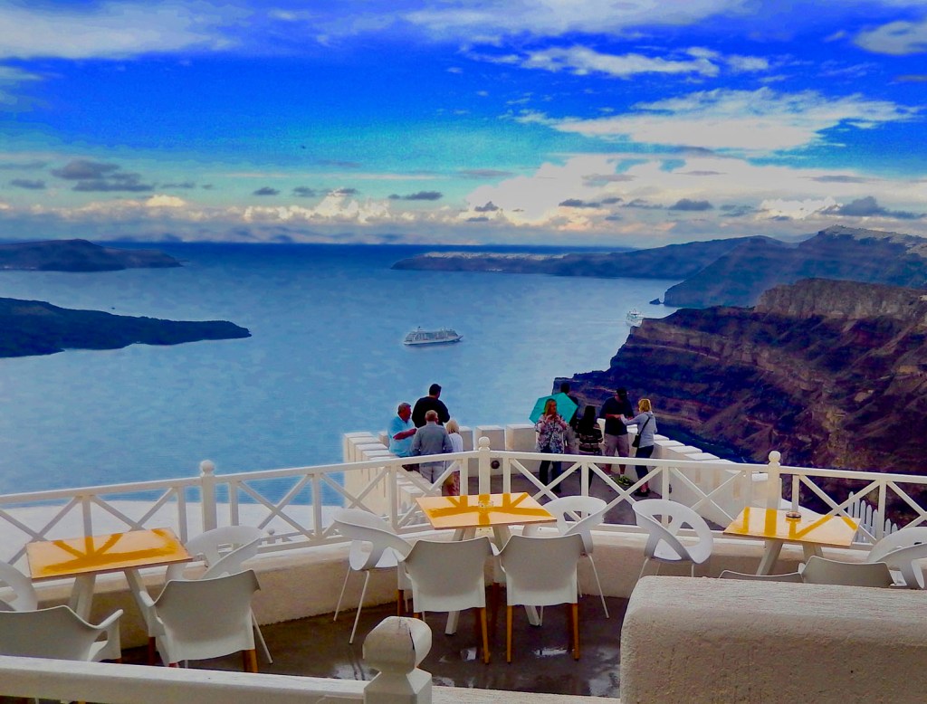
You’re standing on the deck of a cruise ship near Santorini, Greece that’s anchored in the middle of a ring of islands. The near island’s sheer cliffs rise almost a six hundred feet right out of the water. You are looking at the aftermath of the largest explosive event in all of human history.
Over three thousand five hundred years ago* a volcanic eruption devastated the Aegean island of Thera. Scientists have estimated the volcanic eruption magnitude between 6 and 7, causing an ejection of approximately 14 cubic miles of dense-rock. This eruption was the largest volcanic event on Earth in all of human history.
That fiery eruption killed upwards of 40,000 people in just a few hours, while colossal tsunamis 40 feet tall swept across the Eastern Mediterranean, as it spewed volcanic ash well into Asia, and caused a drop in overall global temperatures with the blast itself being heard 3,000 miles away. Thera’s eruption was four or five times more powerful than Krakatoa and exploded with the energy of a thousand atomic bombs in a fraction of a second.
The event destroyed the Minoan city on the island at Akrotiri, with subsequent earthquakes and tsunamis destroying communities and agricultural areas on nearby islands and devastated the Minoan home island of Crete.
In Egypt 800 miles south of the Mediterranean coast on the Nile River, the ancient Egyptian city of Thebes was hit by a terrible storm and flood that devastated the city and surrounding area. A stele was discovered that records this event during the reign of Pharaoh Ahmose I*;
..the gods expressed their discontent… The gods made the sky come with a tempest of rain; it caused darkness in the Western region; the sky was unleashed, without … ?mercy?… the flooding was powerful even on the mountains more than the turbulence of the cataract which is at Elephantine. Each house, … each shelter or covered place that they reached… were floating in the water like the barks of papyrus even to the royal residence for..???… day(s)…
This eruption led to the rapid decline of the greatest Mediterranean civilization of the time, the Minoan, with their cities throughout the islands. Centered on the nearby island of Crete, the powerful Minoan civilization was swept by tsunamis spawned by the eruption, it swamped its naval fleet and destroyed its coastal villages. Next the drop in temperatures caused by the massive amounts of ash and sulphur dioxide released into the atmosphere led to several years of cold, wet summers in the region, ruining crops. The aftermath of the event overran every part of the Minoan civilization in less than 50 years. In just that short time, this advanced, peaceful, efficient empire gave way to the warring city-states of ancient Greece that began to dominate the Eastern Mediterranean.
A number of researchers believe that Thera and the city of Akrotiri is the origin of the legend about the lost city of Atlantis, written about by Plato. There is a lot that seems to fit the story including a recently excavated fresco in Akrotiri showing the ringed canals surrounding a city that was described by Plato.
If you have an opportunity to visit Santorini be sure and make time to see the remains of the Minoan city buried by the eruption. Akrotiri is a major archeological excavation site open to the public that will probably exceed the size of the famous archeological excavations at Pompeii Italy. It is also a treasure trove of some of the worlds oldest frescos, well preserved after being buried in the eruption while still showing remarkable detail and vibrant colors. Akrotiri is located on the southern end of the island. Considering how long ago this city was built it is amazing to see multiple story buildings, complex plumbing that suggests the homes had hot and cold running water and those amazing frescos covering their walls. It also suggests that the residents knew disaster was coming as it seems they fled the island taking their valuable possessions like jewelry with them.
*The exact date of the eruption is still being debated as there is conflicting data but it probably occurred between 1620 and 1500 BC. The Thera eruption is thought to have occurred no sooner than 1500 BCE from archeological evidence, although, based on Greenland ice-core and from tree-ring and radiocarbon dating, some scientists think it may have that it occurred as early as 1620 BC. Even the reign in Egypt of King Ahmose I has been adjust several times as evidence of age of various rulers have been updated. Ahmose I is considered the founder of the the New Kingdom of Ancient Egypt who is currently believed to have ruled from 1551-1526 BC.
As we travel the world I am drawn to taking photographs of graffiti. I believe that graffiti can tell you a lot about a place or perhaps about attitudes of local residents and civil authority. It shows how people feel about the place where they live. At times showing pride but especially in the case of graffiti often displaying disrespect or even contempt. A lot of graffiti is nothing more than visual pollution and vandalism, downgrading a neighborhood’s environment and reflecting a community in decline. By actions or inaction local authorities can create an environment where it can become malignant and out of control. This is obvious when you travel widely and discover places where graffiti virtually does not exist and others where it has significantly degraded the environment.
As a country, Germany is suffering a particular plague with graffiti but recently we visited a community that seemed to have no graffiti at all, Bamberg, Germany. This is a beautiful and historic town popular as a tourist destination. It features winding cobblestone streets, a picturesque riverfront, a famous cathedral along with an unusual smokey beer. Initially we were impressed with the lack of graffiti but after a while we started noticing subtle blotches of paint that didn’t perfectly match the surroundings. It became soon obvious that locals were actively painting over graffiti as quickly as possible in an effort to maintain the character of their town. After asking around we learned that the city was both arresting the “artists” and fining the building owners if they don’t quickly erase the graffiti.
Another measure about a community as a place can be seen in graffiti that is often described as street art. It can actually elevate the areas environment. Often I have thought about where a line should be drawn in prohibiting graffiti while allowing street art and admit I can’t find a clear line. As the old saying goes – I may not know what it is but I know it when I see it.