Civitavecchia, Rome’s Port

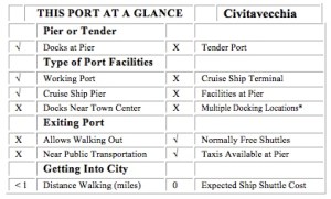
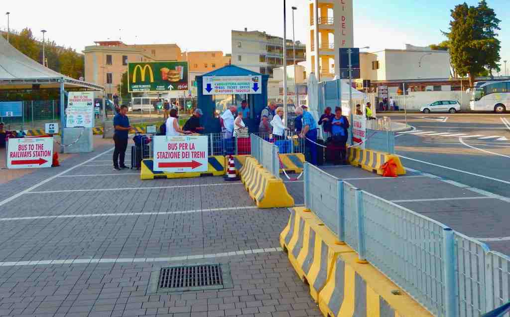
Civitavecchia is a seaside city and the port serving the city of Rome. The city is serviced by frequent train service from Rome along with service to other Italian destinations. The Cruise port is only a short five or six block walk along the waterfront on Via Aurelia from the train station. Once inside the port gate there are free shuttles to the cruise ships. How the shuttles run seems to change often. At times the port runs shuttles to and from the train station.

The main entry to the port is marked on the map with a red 1 but the more likely location to catch the shuttle is marked with a red 2.

Where the Ships Dock – Civitavecchia is both a cruise ship embarkation port as well as a popular port of call and for that reason it can have a large number of ships in port from time to time. On one day we counted seven cruise ships tied up. Because of the size of the port it usually requires a shuttle to get out of the port.

Taxis are available but are famous for overcharging with the short ride from the port to the train station quoted as high as €10 or €15.

Taking a taxi into Rome or to the airport can be an expensive trip with fares running from €150 to €300.

If you are catching a cruise from Rome and are flying in, the cruise ships sponsor shuttle buses from the airport that average $65 per person. If you are on a budget there is frequent train service that can get you to Civitavecchia for as little as $7. Catching the Leonardo Express requires you to go into the central Rome Station and transfer to a local train. You can also catch a commuter local train (FM1) and switch trains at Trastvere station for Civitavecchia. If it is rush hour and you have large suitcases commuter trains can be awkward as the Italians don’t take kindly with bags taking up seats.

The Port Bus Stop
Civitavecchia Pedestrian Mall

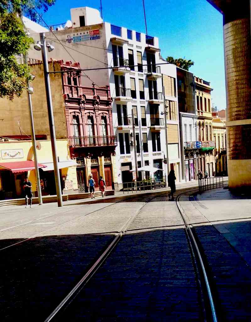
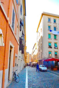
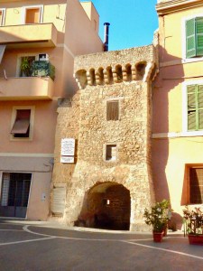
Visiting Civitavecchia – Civitavecchia is a nice city with a number of good hotels and restaurants within walking distance of the port. The main business district is right next to the port and there are a number of shops in the area as well as a pedestrian mall. On most days there is also an outdoor market only five or six blocks from the port entrance that features food and hard goods sold from stalls.

Tenerife, Canary Islands Port of Call

Santa Cruz de Tenerife, Canary Islands

Santa Cruz de Tenerife: The capital city of Tenerife is a vibrant and cosmopolitan city with a rich history and culture and cruise ships dock in the center of town.

Santa Cruz de Tenerife

West of southern Morocco in the Atlantic Ocean sits a cluster of volcanic islands called The Canaries. The Canary Islands feature a rugged volcanic landscape known for the black and white sand beaches. Tenerife, the largest island, is dominated by an active volcano Mt. Teide, which has its own astronomical observatory and is part of Teide National Park. Tenerife hosts a huge pre-Lent Carnival each year in the capital of Santa Cruz de Tenerife.

Where Your Ship Docks

Most cruise ships will dock at the piers in Santa Cruz de Tenerife. There are no cruise terminals or readily available public facilities at the pier. While docked in the city it is still a good walk to reach the central business district. At times there can be shuttles available to get out of the port area.

Wheelchair Accessibility

Disembarking – This port has a developed cruise ship pier but the ease of disembarking varies by the individual ships gangway designs. The xxx pier disembarks right into downtown. For passengers using wheelchairs there can be a moderate ramp incline to deal with in both locations.

Port City Characteristics – This port has an average wheelchair infrastructure typical of European cities. The port area has good walking sidewalks to get out of the port. In town the city slopes up from the waterfront with some uneven sidewalk pavers and intersection crosswalks may have curbs or other wheelchair obstacles.

Transportation

The island does have a good bus system (CLICK HERE) that uses a pass card, the Ten+ Travel Card. It can be used on most all bus routes. The plastic card itself can be purchased at various outlets around the island for €2 plus a €5 minimum charge amount. The island of Tenerife is a large island covering almost 100 square miles with a trip from one end to the other being about fifty miles.

Because of the distances that you need to cover to see the island on a short visit it’s recommended that you rent a car or take a tour.

Currency

The Canary Islands belong to Spain and are part of the EU making the local currency the Euro. Credit cards are widely accepted but you will need to use the Euro for cash transactions. ATM machines are also common.

Attractions

African Market

Don’t miss an opportunity to just stroll the streets of Santa Cruz just a short walk up from the cruise docks. There are a number of good cafes and restaurants and shopping. There is also a city market called the African Market featuring its own restaurants, cafes, along with stalls of produce and crafts well worth a visit.

The Canary Islands are a favorite holiday destination for Europeans, particularly the British. It features a good selection of fine restaurants along with a thriving wine industry with a number of vineyards of note.

Because of the volcanic nature of the island there are a number of interesting sights focused on the geology. Visit the Cueva De Los Verdes, lava-formed tunnel which features guided tours. Also the Jameos del Agua, a volcanic cave system with dining & music that opens each day at 10 am.

Blessed with a near perfect climate, Tenerife has a number of good beaches like Playa de Amadores, a busy beach for swimming and sunbathing. There is also Palmitos Park, a botanic park with an aviary & dolphinarium or Siam Park a Thai-themed adventure water park.

Around The Island Of Tenerife

Mount Teide National Park: This UNESCO World Heritage Site is home to Mount Teide, the highest mountain in Spain and the third-tallest volcano in the world. Visitors can take a cable car to the summit for breathtaking views of the island.

Loro Parque: This world-renowned animal park is home to a diverse collection of animals, including parrots, dolphins, whales, and gorillas. Visitors can enjoy live shows and educational exhibits.

Siam Park: This water park is one of the largest in Europe and features a variety of thrilling rides, slides, and attractions. It is a great place to cool off on a hot day.

Playa de las Américas (Pictured above): This popular resort town is known for its beautiful beaches, lively nightlife, and a wide range of shops and restaurants.

Port Of Call Honolulu, Hawaii

Waikiki Beach and Diamond Head

Cruise Port Honolulu.

Honolulu is a frequent stop for cruise ships repositioning in the Pacific, cruises going out of the west coast of the U.S. and Canada as well as cruising the Hawaiian Islands. It is the largest city in the islands, the states Capital and gateway to Hawaii’s most developed island Oahu.

Honolulu is located on the island of Oahu with a number of areas to visit and sights to see. Nearby the cruise dock is Pearl Harbor with the museums and memorials and in the other direction is world famous Waikiki Beach with the hotels and shopping. This island and city are major tourist destinations and to get a feel for Oahu you need a number of days.

Where The Ships Dock

The cruise piers are located on the northwest side of Honolulu between Waikiki Beach and the International Airport. Cruise ships dock at either the Aloha Tower (pier 11) or Pier 2 about a quarter mile more to the south (primarily used by NCL for Hawaiian cruises). Aloha Tower is conveniently located not far from the downtown area and the Aloha Tower Marketplace. There are facilities located at the cruise terminal and you can walk out without much difficulty. “Downtown” with its shopping and “Waikiki Beach” are not the same location so if you want to visit this famous beach area you will need transportation.

Cruise Ship Piers Oahu
Transportation

Our preference to really see the island is to rent a car. Rates are usually very reasonable and since you are in the United States your insurance covers the rental car. Oahu is a pretty big island with 3 major highways (H-1, H-2 and H-3) and we would strongly suggest that you use GPS navigation or navigate by your phone. The street names are difficult to pronounce and remember and the roads tend to wind around.

Wheelchair Accessibility

Embarking/Disembarking – This port has a developed cruise ship pier but the ease of disembarking varies by the individual ships gangway designs. For passengers using wheelchairs there can be a moderate ramp incline to deal with in both locations. From the pier it is several miles into downtown.

Port City Characteristics – This port has a well developed wheelchair friendly infrastructure. The port area is flat or has few inclines. Intersection crosswalks have few issues with curbs or other wheelchair obstacles.

Currency

This is the 50th state and the US Dollar is currency. Most major credit cards are welcome and you will find plenty of ATM machines.

Transportation

The primary comment on the Waikiki Trolley is it’s way overpriced for what you get to see. Again “TheBUS” Day Pass is much less expensive and covers the same routes. To see more of the island you’ll need to rent a car and there are several rental agencies near the pier. A short taxi ride into the center of Waikiki Beach is also good investment. If it’s going to be a first trip don’t miss a visit to Pearl Harbor with the USS Arizona Memorial and the USS Missouri.

Attractions

In Honolulu there are almost too many attractions to count, from shows to an aquarium and zoo. The best view on the island requires a car for a drive up to Hawaii Puu Ualakaa State Park with an overlook above Honolulu on Mount Tantalus.

Pearl Harbor

A must visit is Pearl Harbor and the Arizona Memorial. It is a popular tourist destination and is visited by millions of people each year. It is a powerful reminder of the attack on Pearl Harbor with its Visitor Center and museum.

If you have the time and a car the North Shore with the surf at the Banzai Pipeline and Waimea Bay, a number of great small towns to explore (look for the food trucks) and Waimea Falls Park are great destinations. There is also The Dole Plantation (don’t miss having a Dole Whip) in mid-island and a couple of beautiful gardens to check out. Above all is the ocean and the beaches and the reefs. Snorkeling and diving opportunities abound and depending on the season you can go out on a tour boat for whale watching.

Click above to download a pdf of this map

Ushuaia, Argentina’s Port of Call

Ushuaia The Gateway to Antarctica

Introduction

Ushuaia is often referred to as the end of the world and is the capital of Tierra del Fuego, Argentina. It is recognized as the southernmost city in the world. Ushuaia is located in a wide bay on the southern coast of Isla Grande de Tierra del Fuego, bounded on the north by the Martial mountain range, and on the south by the Beagle Channel. It is a popular port of departure for ships and expeditions headed to Antarctica. A little over a decade ago the cities population was less than 10,000 while today it is approaching 100,000. This is partly due to the growing popularity of Antarctic tourism but equally because the Argentinian government has encouraged manufacturing with special tax breaks as well as subsidies for people living here.

The Beagle Channel is the most southern natural channel connecting the Atlantic with the Pacific and has been a popular shipping lane. South of the Beagle Channel is Tierra del Fuego which means land of fire. Because the area was often shrouded in fog early explorers called it the land of smoke which was exaggerated in Europe for advertising purposes into land of fire. A large part of Tierra del Fuego is an Argentine national park.

Where Your Dock

Ushuaia has a large pier right at the cities waterfront capable of handling most ships. It is usually busy in season with expedition boats getting ready for Antarctic tours along with large cruise ships rounding the Horn or setting out for Antarctic waters. Right at the end of the pier is the cities visitor center with facilities and information on tours and the city. Also along the waterfront are a number of tour booking offices.

Transportation

While the city has a population of almost 100,000 it is geographically compact with most restaurants, cafes and shops located within a ten by six block area. Even though the Pan-American Highway passes through the city the area is so isolated with no other towns or cities within hundreds of miles. The areas big attractions for visitors is the national park and the incredible animal life on islands in the Beagle Channel which are best visited on a tour boat.

Currency

At this writing the exchange rate is about 38 Argentine Pesos to one US Dollar. Because of inflation rates over the past several years buying Pesos before leaving the United States is almost impossible. In the city many shops will accept Euros and American Dollars but it is advisable to exchange some currency for convenience. Credit cards are welcome and it is recommended to keep the charges in local currency to avoid unusual charges.

Attractions

Parque Nacional Tierra del Fuego (Tierra del Fuego National Park) is probably one of the major attractions in the area. It is also the terminus of the Pan-American Highway that ends in a narrow dirt road inside the park. There are also a number of islands near the city in the Beagle Channel that are popular with penguins, seals, sea lions, cormorants along with whales depending on the season. There are a number of tour boats along the waterfront to book.

In town there are a number of excellent restaurants, cafes, and chocolate shops along with gift shops. The city also can boast that they are home to the most Southern Hard Rock Cafe in the world.

Cruising To Antarctica

Occupying a land area about the size of the United States and Mexico combined, Antarctica is the highest, driest, coldest, windiest and brightest place on Earth. It is completely covered by a layer of ice that averages more than one mile thick, but is nearly three miles thick in some places. It is without question the loneliest place on the planet.

Over the past decade the frozen continent has hosted less than forty-five thousand researchers and visitors per year. The requirements that define and manage how visitors travel in Antarctica is controlled by the International Association of Antarctica Tour Operators. One of the rules is that any vessel holding more than five hundred people is not allowed to put anyone ashore while visiting.

Just imagine that we live at a time when we can actually take a vacation to the continent of Antarctica. Never in our wildest dreams would we have thought something like this possible. Today there are a number of options for visiting.

An expedition boat prepares to sail to Antarctica

If you would like to visit and go ashore there are a number of expedition boats that travel to Antarctica that carry about one hundred passengers and land using Zodiac rubber boats. We talked to several people while making our way south that were taking advantage of that option and indicated that the fare runs between $10,000 and $20,000 per person for a week-long trip. Luxurious accommodations can also be booked on major cruise ships starting at about $3,000 for a two week cruise.

Expedition boats dock next to the Celebrity Eclipse in Ushuaia

On of the reasons that Antarctica is so isolated and harsh is that it is ringed by the Southern Ocean with a circular current that races around the continent. Some of the worst weather on Earth is in Drake Passage, that is the gap between Cape Horn in South America and Antarctica, that is often afflicted with high winds and heavy seas.

Lighthouse in the Beagle Channel

Many of the expedition trips to Antarctica start from up the Beagle Channel at the city of Ushuaia at Terra Del Fuego. This city has grown to a population of almost 100,000 with a lot of help from the Argentine government. It is also usually a last port of call for large cruise ships heading south to the frozen continent.

Terra del Fuego National Park at Ushuaia

We chose to travel with a bit more luxury and a lot more stability and cruised with the Celebrity Eclipse out of Buenos Aries in January (summer season). After a port stop in Ushuaia we headed out for our first destination in Antarctica, Paradise Bay. Passing the “light house at the end of the world” and the Mariners Monument, we entered Drake Passage facing high winds and twenty foot plus seas for a rocky afternoon and evening. The next morning the Sun broke out as we approached Antarctica with ice bergs the size of Manhattan in the distance. The seas calmed, the sky turned blue and the temperature soared to 35°F as the Eclipse became the largest ship to ever enter Antarctica waters.

The Mariners Monument at “the end of the world”

breaching Stark, snow drifted mountains towered above the horizon and ice floated everywhere with many icebergs being as big as our ship. We sailed for hours up the channel toward Paradise Bay and were told the area had the most snow covering along the shoreline for this time of year that’s been seen in a long time. The water around us was full of whales and penguins that shot by like little black torpedoes. Albatros and other sea birds where everywhere. The professionals that were with us said they hadn’t seen such a beautiful day in over six years and we couldn’t imagine how it could have been any better.

Albatros at the end of a perfect day

Just a decade or two ago a visit to Antarctica was something never considered possible by tourists. Who would have thought that this incredible, isolated, frozen continent could become a travel destination? There is really no way to describe this experience in words so I’ll close by simply suggesting that this should be added to wanderers bucket list.

Of Ships, Itineraries And Interest

Itineraries, cruise ships, selecting staterooms, shore excursions, getting to your cruise, ideas on saving when booking a cruise and more…

General Interest Articles

• Customs and Duty Free Purchases

• Beating Seasickness

• Getting To Florida Cruise Ports

• Why Use A Travel Agent

Travel Apps For Your Phone

Healthy Flying Practices

Anchors Away

Dreaming of summer evenings sailing the Mediterranean, the feeling of tropical sand beneath your feet and ocean breezes? There’s a cruise cure for that.

Selecting The Right Cruise Ship And Stateroom, Deciding On An Itinerary And Departure Port, Onboard Packages And Excursions? Let Us Offer Some Advice.

Cruise Ships Rated

• Cruise Loyalty Programs

• Save Money When Booking

• Selecting A Stateroom

Shore Excursions

Looking For Spectacular Scenery, Tropical Beaches, Exotic Destinations Or Historic Places? It’s All There Just For The Booking!

• Selecting An Itinerary

• Alaska Cruises

• Cruising The Caribbean

• Mediterranean Itineraries

• Cruising Down Under

• Asia Itineraries

• Exotic Destinations

• Repositioning Cruises

Staterooms

Suites, veranda staterooms, outside and inside cabins the choices are many and varied. There are a number of important things to consider when choosing your cabin including size and location.

Speciality restaurants…

WHERE WOULD YOU LIKE TO CRUISE?

Extraordinary Places To See And Amazing Tours To Take

The world is full of incredible sights and some are so remarkable that they deserve some special attention. Here’s just a sampling of some of our favorite places.

• Giants Causeway

• Iguazu Falls

• The Falklands Penguins

Seeing Rome In 1 Day

• Pointe Du Hoc

• Tierra del Fuego

• Australia’s Blue Mtns

• A Greek Museum

• Alaska’s Denali

• Barcelona’s Mtn

SUBSCRIBE

Get notices of our official launch along with updates on cruise ports of call, ships store additions and more good cruising information