Camp Shelby Mississippi And A Museum

Just outside of Hattiesburg is a Mississippi National Guard training base called Camp Shelby. It is a large base with a really remarkable museum. The Mississippi Armed Forces Museum honors the servicemen and women of all branches with exhibits that often tell the personal stories of Mississippians who served their country.

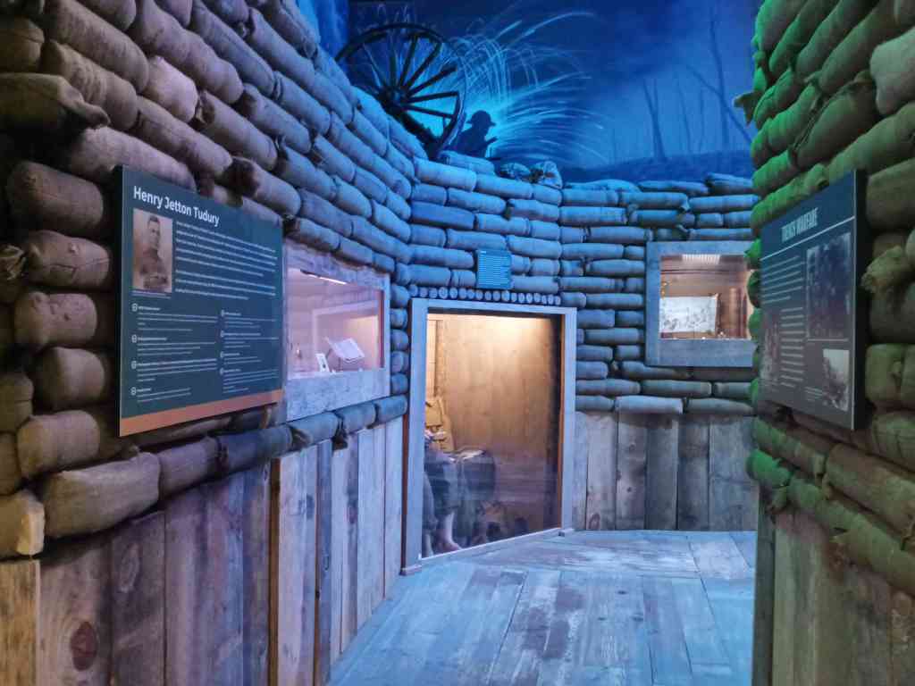
It features great displays offering a well presented history of the wars fought by this nation, but the most remarkable aspect of the museum is the personal stories. Dozens and dozens of exhibits tell the stories of these individuals like a young man who immigrated from Italy with his parents in the thirties and joined the army right after America joined the fight in WWII. He was not yet a citizen and because he was technically Italian he was sent to an internment camp. Two months later he rejoined the Army, became a Ranger and parachuted into France on D-Day. He jumped again on operation Market Garden, remembered in the movie A Bridge Too Far. After the war he returned to Mississippi, bought a farm got married, had five children and lived to the age of 93.

Fascinating accounts of individual pilots and Marines, sailors and soldiers who fought in the Civil War, the Mexican War, WWI, WWII all the way through Desert Storm and their lives after service in Mississippi.

The museum’s goal is to educate future generations about the price paid for freedom and prosperity by the people of Mississippi.

Red Bluffs Mississippi

Mississippi Odyssey

Take A Hike or The Attraction That Could Be

Where the road ends

We’ve overlooked Mississippi. It always seemed that there were much more interesting or attractive places to visit and the truth is we focused much of our travel itineraries on international destinations. Our attention was initially drawn to Mississippi by a show on HGTV called Home Town and recently we decided to spend some time exploring the state.

Before heading out we were looking for hiking opportunities and discovered a place called Red Bluffs and it sounded interesting. A red clay canyon eroded through the rollings hills of south-central Mississippi.

After spending some time in Hattiesburg we headed off one morning to spend a day exploring Red Bluffs. It’s about 45 miles west of Hattiesburg and it isn’t an easy place to locate. The car’s GPS had no idea, while navigation on an iPhone located the route to the canyon. After almost an hour of driving Mississippi’s rural roads the phone indicated that we should make the next right. Two hundred feet down that road there was a sign indicating the road was washed out.

Welcome to Red Bluffs. When we pulled up on the dirt near the end of the road there were just two men there flying a drone. In talking we learned that this was the first time they had been back in ten years and what remained of the road now was some blacktop caps on red-orange spires going off across the “canyon”. The area is beautiful but it s not a park or a protected area but is private land. The end of the road is just a drop off of a couple of hundred feet with some piles of dirt on the road to keep cars from driving over the cliff.

We walked a trail along the canyon rim off to the left and it descended sharply and ended in about a hundred yards or so. The end is a point in the woods with steep drop-offs on three sides. Along the trail there were a couple of steep eroded gullies with one having a rope tied to a tree for the adventurous to use to get down into the canyon. Climbing back up we tried a trail heading off in the opposite direction but it also ended in the woods with a very steep slope dropping into the canyon.

Back at the car we chatted with the men flying the drone and they explained that the eroded walls of Red Bluffs ended in both directions in about five hundred yards or so and that the canyon was only about a hundred yards wide.

The Red Bluffs are beautiful and seem to represent a lost opportunity. Developing some hiking trails in the canyon, providing a parking area and maybe a concession could actually regularly attract a number hikers but we doubt that that is likely to happen anytime soon.

All in all not what we intended to do that day…

Intend2Travel’s World in 120 Seconds

A Celebration For Earth Day

A very long time ago a couple of popular television shows whould do segments called “speed seeing”. I have always been amazed at how much information can be processed in a very short time spans. The segments actually got frame viewing rates down to 1/12th of a second. The shortest I have been able to get from my video editing is about 1/6th second. See if you can name the countries, cities and places?

Take a peek at this magnificent world in about two minutes…

Now that COVID is letting up we’re back to planning for the next year or so that should include Portugal, Spain, Italy, India, Sri Lanka, Jordon, Egypt, Malta, Paris, Dubai, Singapore and hopefully the East coast of Africa…

Images On A Hawaiian Holiday

Photographic impressions from our travels…

Oahu North Shore

Oahu Southeast Coast

Hawaii is truly the American Paradise and Oahu is the island that stands at the center of this remarkable island chain both literally and figuratively.

Waikiki Beach
On The Island Of Maui

The Church of the Holy Sepulcher

The History Behind The Celebration Of Easter Without question the holiest site in all of Christendom is located in the Christian Quarter of Jerusalem. It represents the location where Jesus was crucified and where his body was laid to rest. Today there is a high level of certainty that the location has been actually identified.…


A Steam Railroad In France – Tournon Lamastre

Going Back In Time

On a recent trip through France we spent time visiting the Tournon Lamastre Steam Railroad line which features open-air cars (in the warm months), beautiful old steam engines and fantastic scenery.

About 125 miles north of the city of Avignon along the Rhône River in southern France is Doux Gorges, located in Saint-Jean-de-Muzols, a commune (community) in the Ardèche department. The area features some of the most beautiful and remote wilderness in France and attracts tourists, hikers and bikers from all over.

A  network of railway lines was constructed around Vivarais between 1898 and 1903 to provide access to markets for farms and vineyards in remote areas of the region. When the Vivarais railway network closed in 1968, a group of enthusiasts decided to acquire it and some of its’ rolling stock. In June, 1969 a tourist operation started between Saint-Jean-de-Muzols and Lamastre. The Meyzieu Tourist Railway Company (CFTM) was created, supported by a group of volunteers who restore and maintain the railroad rolling stock. In February, 1970 access was restored to the railway station at Tournon, and the new Tournon – Lamastre line, 21 miles long, was officially opened for full service in April 1970

At the Train de l’Ardèche station
The journey begins

Pulled by restored and beautifully maintained steam engines over one hundred years old, today’s train cars carry passengers into the most beautiful and inaccessible part of the Doux Gorges. the trip offering views of an untouched and rugged landscape. At the station of Colombier le Vieux – Saint-Barthélémy le Plain, the locomotive has to be turned round on a turntable and placed at the front of the train for the return trip. Watching the two men push the turntable is a sight worth seeing.

Offering full day or half day excursions, the Train of Ardèche travels through the mountainside overlooking the gorges. It is particularly popular with hikers and bicyclists (who can load their bicycles aboard) for the trip uphill to Lamastre and then the walk or ride back downhill through the gorge. The trains do not run everyday so it is important to check the schedule when planning the trip (official site link below).

Visit the official web site HERE.

The engine turntable at Colombier le Vieux

Our Map Collection

Maybe We’ve Been There?

Navigating with a cellphone is great but sometimes the best option, especially for making plans, is a paper map. Over the years we have collected maps while visiting places around the world and have marked them up with attractions to see and routes to follow. On occasion we have modified maps before our trip to help simplify a place and how to best get around. Here we offer a number of our travel maps that cover major cities, metro systems, parks and hiking trails. Feel free to download, use and print these pdf files to help plan your future trips. Clicking on each map will set-up the download page.

Amsterdam Tram Routes – The best way to get around Amsterdam is by the tram system. It’s fast, comfortable and inexpensive.

Seeing Budapest using public transportation – Budapest is a wonderful city with a remarkable public transportation system. Modern light rail and subways can take you all around the city.


The Trains of Metro Rome Rome is a large metropolitan area with commuter trains servicing the international airport, the historic center and the seaport of Civitavecchia. Using public transportation can save time and money.


Bus routes on Maui, Hawaii – This island has an incredible public bus system that will take you around the whole island except up through the National Park.


Key West Florida is an American original – Easy to get around on foot the heart of this town is a joy to explore.


Public transportation Sydney Australia – A fantastic, modern city with a great public transportation system that includes regional trains, light rail and a fleet of ferries.


Driving Oahu and seeing the attractions – Oahu is an island you need to drive around but there are- a couple of bus routes that service Honolulu and the Pearl Harbor area that are convenient.


Walking tour of Florence – City walking tours are all the rage now and this one lays out a self-guided tour of of this city south of the Arno.


Rome’s Metro System – A simplified guide to Rome’s Metro system from the port of Civitavecchia to the International Airport.


The Forum in Rome – A 3D map of this ancient Roman site.


One day tour of Rome – A guide to hitting the major sites in just 8 hours on your own.

Colonial Williamsburg

Mt. Rushmore National Park. A good map for deciding where to hike at the park.

The Ringling is the heart of Sarasota, Florida. A remarkable collection of art and circus memorabilia.

Paris Metro – a simplified guide – The Paris Metro is world renowned and here we offer a simplified system map focused on the main tourist destinations.


Singapore Metro Map – Inexpensive, incredibly clean and efficient this city’s metro is one of the best in the world.


Disney World Transportation Systems– Larger than New York’s Manhattan the Disney people have provided an efficient system to get you around that includes buses, boats, monorails and cable cars.


Tourist Guide to Singapore bus routes – In addition to the Metro there is a modern fleet of mostly double-decker buses that can take you around the central city, along the coastal Marine Parade area and to the airport.


The Trails of Iguazu Falls Argentina This park has over 30 miles of trails and it’s important to know which ones are the most spectacular to get the most from your visit.


The New York subways are fast way to see Manhattan and this map eliminates everything but the Manhattan stops and the locations of major sites.


Yellowstone National Park is the size of the state of Delaware and you should need a plan before you get there. Here are 5 major attractions along with driving routes.


Utah Driving Park Tour – Utah has the countries largest collections of National Parks along with some great state parks.


The Acropolis in Athens – A 3D map of this ancient site.


Mendenhall Glacier – Hiking trails around the glacier and the glacial lake.


Hiking Haleakalā National Park – Hiking trails on Maui’s great volcano.

Australia’s Blue Mountains. Only a short train ride from Sydney the Blue mountains are a great trip for a day or two with lots of hiking trails.

The Blue Ridge Parkway includes several dozen of great hiking trails needing some planning to decide where to plan your hikes.