Getting Around Budapest

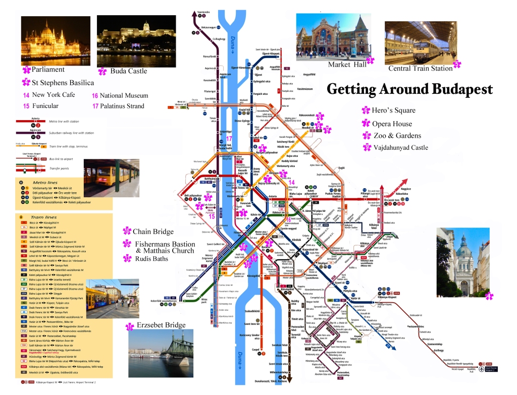
Click the map above to download our pdf Budapest Visitor’s Map re-imagined  to get you to the major attractions using public transportation.

The first problem trying to get around in Budapest is the Hungarian language. While many Hungarians speak English you will find few maps, signs or streets in anything but Hungarian. If you follow the tips here you will quickly get the hang of navigating through this city and its public transportation. 

Budapest is a remarkable, beautiful and large city with the Danube River running thru the middle of it. Along the river in the central city are four major bridges. Starting from the north at the southern tip of Margit Island is Margit Bridge.

Hungarian Parliament Building

Margit hid or Margaret Bridge is a bridge carrying trams, cars and pedestrians connecting Buda and Pest along with access to Margaret Island. It was designed by French engineer Ernest Goüin and built by the construction company Maison Ernest Goüin et Cie. between 1872 and 1876. Margaret Bridge was the second permanent bridge in Budapest.

Next is the Széchenyi Chain Bridge. Designed by the English engineer William Tierney Clark and built by the Scottish engineer Adam Clark, it was the first permanent bridge across the Danube in Hungary. It was opened in 1849.

Next is Elisabeth Bridge (Hungarian: Erzsébet híd) is the third newest bridge of Budapest. The bridge is situated at the narrowest part of the Danube in the Budapest area, spanning only 290 m. It is named after Elisabeth of Bavaria, a popular queen and empress but often referred to by locals as the “White Bridge”.

Going south the fourth bridge is Szabadság híd (in English it means Liberty Bridge or Freedom Bridge. It was originally named Ferenc József híd (Franz Joseph Bridge). At its two ends are two public squares, Gellért tér, at the foot of Gellért Hill, next to the Gellért Spa and Fővám tér at the Great Market Hall. Built as part of the Millennium World Exhibition at the end of the 19th century, the bridge features art nouveau design and mythological sculptures.

Station on the Budapest subway

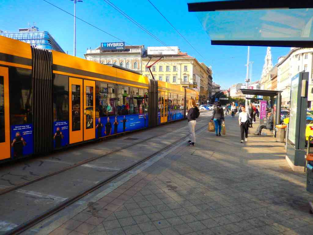
Navigating the city by surface streets can be confusing with neighborhood streets seeming laid out like a maze. Many areas have very few streets that are laid out in a square grid pattern but rather seem to zig zag back and forth. For this reason even trying to use a street map for navigation can be frustrating if you are walking. If you are walking to destinations we recommend using a cell phone for navigation. Fortunately major tram routes and subways trace prominent paths thru the city and stops are mostly found at major intersections.

Budapest has a very efficient and inexpensive metropolitan transit system. The best option if you are going to be spending a couple of days in this city, is to get a Metro “day pass” which averages about $6.00 per person per day or less and is available in one, two and three day passes. A day pass operates on a 24-hour cycle so if you buy one at 10:00 am it can be used until 10:00 am the next day. You can purchase them from vending machines but our recommendation is to purchase them from a manned ticket window open during business hours at most major stations. These are usually at major street intersections where you will find there are stairs going underground that are often also the best way to cross large city streets. While an amazing number of Hungarians know a passing amount of English, signage is another story in this city. Finding good signage in English is actually very rare in Budapest. Beside being able to talk to an agent about purchasing the best pass for your needs, they will also give you a complete set of pocket maps with some information brochures in English that are not available at the machines. The metro system is based on individual tickets based on tapping onto trams and busses. If you buy a day pass you do not need to tap on or off the various transports but simply have the passes with you. The truth is that after three or four days of riding rapid transit, nobody ever asked to see our pass.

Tram stop on the Route 4 line

One exception to that was one day we bought a train ticket for an hour trip out to Slovakia which offered a partial discount off the price if we had an active transit pass. The conductor on the train did want to see our metro pass to confirm that we were entitled to the reduced train fare.

Metropolitan transit in Budapest has three primary systems. They are subways, buses and the street trams. The easiest to navigate are the surface trams which are clearly marked on maps by their routes. They also have the advantage of being operated at street level where you can see where you are.

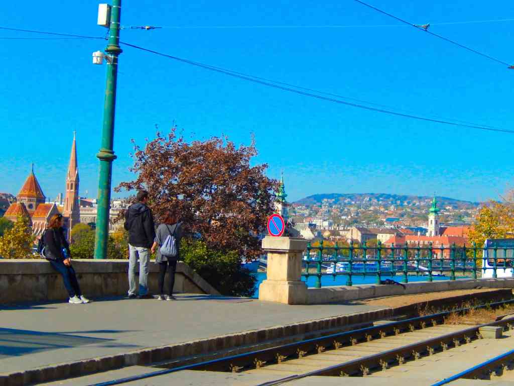
As a visitor think about Budapest as being divided up into several areas of interest. First the city is divided by the Danube River. The east side of the river is the old city of Buda with most areas of interest located within a mile of the river. Much of this terrain is steeply inclined up to the fortifications, the castle and Matthias Church and the old city. There is also a funicular that goes up to the castle level from near the Fisherman’s Bastion.

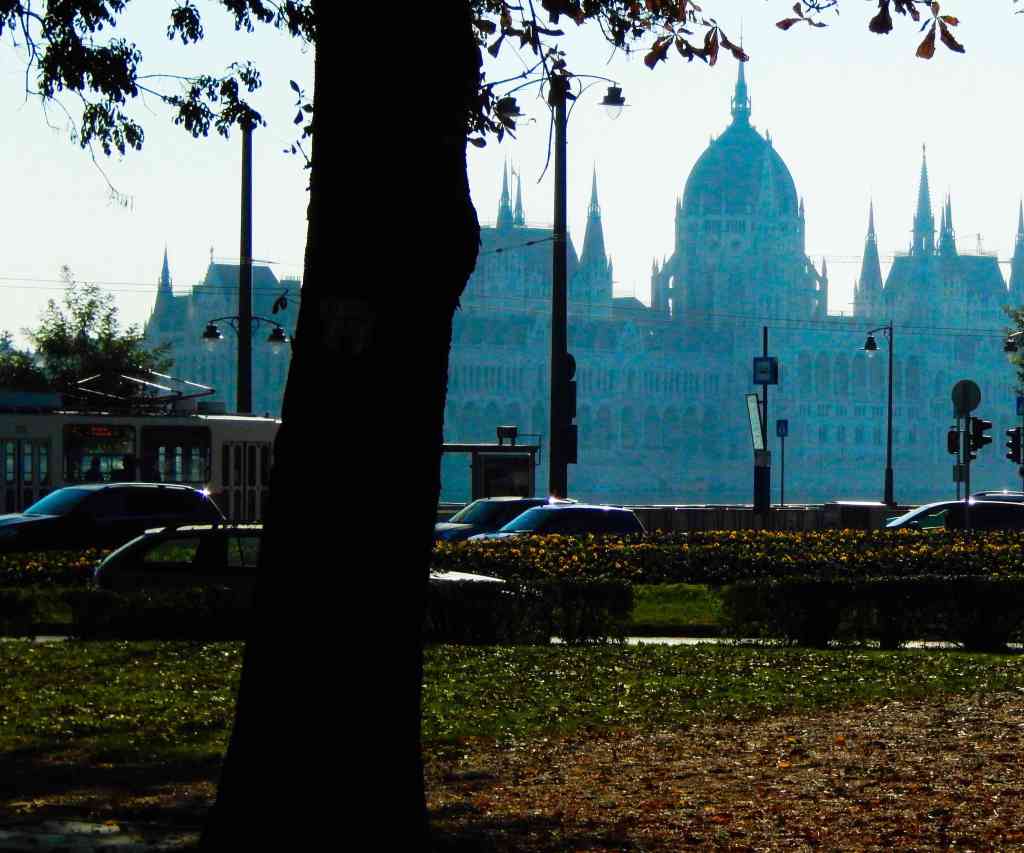
The west side of the river is the old city of Pest and includes most of the large commercial areas and additional major attractions. Some major sights include St. Stephen’s Basilica, The Hungarian Parliament Building, Hero’s Square as well as a number of major museums and galleries.

There are two primary tram lines designated 4 and 6 inside the central city that cross the river at the Margit bridge and the Erzebet Bridge. These two lines are major routes for people to use going to work and shopping and can get busy at times. Along these routes are the Central Train Station, the Market Hall, the New York Cafe and the Octagon intersection. From Octagon you can switch to the #1 subway line to get to Hero’s Square, the National Museum and or toward the river to the Opera House and a popular restaurant neighborhood.

There is an intersection of tram routes 4 and 6 with the #4 subway line at Jozsef Krt and Rakoczi Ut where you can switch routes and take the subway toward the Danube..

The easiest way we found to use the trams and subways is to know the map location where you get on and count the number of stops to where you are going, Understanding the Hungarian tram and subway announcements is often difficult and reading stop locations can be a challenge. Also station names at the various stations in the subway are poorly marked. For example boarding a west bound subway at the Octagon station and wanting to get off at Heroes Square to visit the gardens simply count five station stops.

After just a couple of trips you will easily get the hang of the system. Rush hour is also an interesting time on the trams. When the doors open on a packed full tram you will quickly realize that the crowd behind you believes there is plenty of room for a number of additional riders inside. You may be reluctant to push in but the next thing you know you are right there, packed into the car that you thought you wouldn’t fit into. Don’t worry most everyone is friendly and accommodating. Also if you aren’t sure where you are ask for help. We rarely found anyone that couldn’t understand some English and were happy to help.

Florida’s Circus Town

After over forty years in Florida we finally made the time in Sarasota Florida to spend a day at The Ringling. The estate is focused on the John and Mable Ringling Museum of Art but the estate is actually a 66-acre museum complex featuring the State Art Museum of Florida, The Circus Museum and Education Center, the Ringling’s Ca’ d’Zan mansion, and Bayfront Gardens. At $22 admission it’s a great value and an experience worth returning to over and over again.

Sarasota has meant circus for almost one hundred years. First, the city became the Winter Quarters for The Greatest Show on Earth with its thousands of workers, performers and associated infrastructure. Later it became a tourist attraction centered on the Circus Museum and today it is know as the city that John Ringling built.

John Ringling was one of the five brothers who owned and operated a circus called “The Greatest Show on Earth.” His success with the circus and entrepreneurial skills helped to make him, in the Twenties, one of the richest men in America, with an estimated worth of nearly $200 million. In 1911, John and his wife, Mable, purchased 20 acres of waterfront property in Sarasota. In 1912, they began spending winters in what was then still a small town and years later Sarasota became the Winter home of the circus.

In the early 1900s three of the five Ringling brothers died unexpectedly. John Ringling in 1918, after hardships caused by WWI and the flu pandemic, made the decision to merge the Ringling Bros World’s Greatest Shows and the Barnum & Bailey Greatest Show on Earth into one giant circus. On October 8, 1918 the Ringling Bros. season concluded in Georgia and the various circus trains were routed to the Barnum & Bailey Winter Quarters in Bridgeport, Connecticut. and on March 29, 1919, the Ringling Bros. and Barnum & Bailey Circus opened in Madison Square Garden in New York City.

John and Charles Ringling had been speculating on Florida real estate and John and his wife Mable had built their mansion and a world class art museum in Sarasota. Partly to boost the value of their real estate holdings they decided to move the Greatest Show On Earth’s Winter Quarters to Sarasota, Florida in 1925. Although a resident of Sarasota, Charles died in 1926 before the move was complete. With the death of brother Charles, John was now the last of the Ringling brothers.

The success of the circus and the the greatest show of all, the incredible Ringling Bros, Barnum & Bailey Combined Circus continued well into the 1970s when changing times and public tastes began to have an impact on the circus business. Even today the circus still has the power to fascinate people and continues to draw people to Sarasota’s The Ringling.

DIY Travel Pin Maps! Free!

Our own travel pin map

What, you don’t have a pin map? Well, let’s fix that…

If you love travel, keeping a travel pin map is a great way to keep track of where you’ve been while also a fantastic decorating accent. We started ours years ago and even today it is a fantastic conversation piece.

Years ago we started getting requests from family and friends to make one for them. It became a favorite gift item and after a few dozen maps we decided we’d try selling them online.

We started selling on Etsy with a few world map color versions and added a United States map. We offered a selection of titles and provided personalization included (all our friends and relatives wanted theirs personalized). Within a couple of months sales took off and soon I was spending hours printing and shipping maps. A few dozen a week wasn’t going to make me rich but it was eating up a lot of my week. After about six months I shut it down because it was just too much work…

After a lot of prodding we’ve decided to put in some more time exploring our travel pin maps again. After talking to a number of friends about the process and discussing options we’ve started developing a plan.

This time we’re using a do-it-yourself approach and if you follow our steps you’ll have a decorating accent to be proud of!

Making Your Custom Travel Pin Map

Here’s how to create your very own custom 16×20″ pin map for under US$50 in five simple steps:

  • Get our pin map at Etsy HERE* (Please note that for a few of weeks our Etsy shop is on vacation – so we’re making our visitors a special limited time offer*.

*While we are traveling you can download our pin map for FREE instead of buying it on Etsy.

  • Print it up to 16×20″ At Walmart or Office Depot
  • Pick out a standard 16×20 frame
  • Remove glass in frame and back up with a sheet of foam board
  • Get a set of map push pins

Do It Yourself  Instructions For Our Travel Pin Map

Download Our Map And Make It Your Own

Customizing Your Map

Microsoft

Microsoft offers several software tools and services that can be used for annotating our JPG map file that include:

Our files are formatted in a 4:5 ratio that will produce prints from 4×5” through 16×20” and are provided in an open jpg file format that can be customized using many standard applications in computers using MS, Apple and Google operating systems by following the steps outlined here.

• Microsoft Paint: A basic image editing program included with Windows that allows users to add simple annotations such as text, lines, and shapes to images.

• Microsoft Office Picture Manager: A more advanced image editing program that comes with Microsoft Office and provides more features for annotating images, including the ability to add captions, watermarks, and other effects.

• Microsoft OneNote: A digital note-taking application that allows users to insert and annotate images, including JPG files.

• Microsoft SharePoint: A cloud-based collaboration platform that allows users to store, share, and annotate images, in JPG files.

Apple Macintosh

Using the Preview application:

• Open the JPG image in Preview.

• Click the “Markup Toolbar” button in the toolbar.

• Select the annotation tool you want to use, such as the “Text” tool, “Shape” tool, or “Arrow” tool.

• Click and drag on the image to create your annotation.

• Adjust the properties of the annotation, such as font, color, and size, using the options in the Markup Toolbar.

• Save the finished file for printing.

Google Operating Systems

With a Google computer using Google Cloud, This system offers a comprehensive platform for image annotation. It provides a suite of tools and services that enable users to annotate JPG images efficiently and accurately providing powerful image editing tools that facilitate the annotation process. Users can easily draw bounding boxes around objects, add polygons, or even create 3D annotations. These tools ensure precise and consistent annotation, which is essential for high-quality machine learning models.

Printing Your Map

If you have access to a printer that can print to a sheet size of 13×19 you can print your map yourself at either 11×14 (standard frame size) or use 13×19 paper trimmed to 13×16.

Large prints can be ordered from a number of sites including Office Depot and Walmart. If you have a wide format (13×19) you can of course print it yourself.

Print yours with Walmart Custom Prints. The 16×20” print is the best format at under $14.00 and the order can be placed with your local Walmart online at the web page below.

Click Walmart Link HERE

Framing Your Map

Our maps when printed can be formatted to fit a 16×20” standard size frame, or 11×14”, 8.5×11” and 8×10”that are available nationwide from many stores like Michaels or Walmart as well as online. In order to convert the frame to a pin map all need to do is to remove the plastic or glass front, back up the map with a sheet of foam board and reassemble. See a good choice from Michaels HERE.

Pushpins

Hopefully you’ll be adding a lot of pins to your map and while you can find push pins in most office supply departments we recommend a smaller headed shorter pin made for that purpose and recommend Yalis Push Pins 600-count Map Tacks available from Amazon HERE.

Esperance, Australia A Port Of Call

Esperance is 434 miles southeast of Perth but in a world all its own. Esperance is a remote town in the south east of Western Australia. Because of its remoteness the town has a self contained character with the next significantly sized town being 275 miles away. Also, Esperance is not located on any major highway meaning it is actually the destination for most town visitors. The town has taken advantage of the ‘destination’ character and the surrounding area by developing a significant tourism industry focused on the remarkable beaches and incredible scenery.

One of Esperance’s major claims to fame is that on July 12th 1979 America’s space station, Skylab fell out of orbit with pieces raining down on the area.

Where Your Ship Docks

Because the town is the only port facility for several hundred miles of coast, it hosts a developed deep-water port. Smaller cruise ships can tie up at the towns pier but larger ships will be required to tender in with only a short walk into town.

Transportation

There is no public transportation in town but it does offer a couple of rental car options. If you would like to tour the area on your own there are a couple of rental car agencies in town. Avis has an office in Esperance, where you can select from a range of car options and seasonal specials but it’s recommended that you make a reservation in advance.

Currency

Australia has its own Dollar (A$) and US Dollars are generally not accepted. Most major credit cards are welcome and there are ATM machines available in town. The recent exchange rate is about A$ 0.81 = US$1.00.

Attractions

The amazing scenery of Esperance attracts Australians from all over the continent. Clear turquoise waters wash up on miles of white powder beaches, kangaroos freely roam the area and a nearby island has a lake so pink, it challenges belief.

There are a few tours available and attractions in the area that include the Esperance Stonehenge, the Great Ocean Drive circular loop recommended for seeing the beautiful coastal scenery and perhaps a walk or swim at some of Western Australia’s best beaches.

Esperance Walking Tours – is a pleasant stroll thru Esperance’s past by local guides. Discover the cultural and historical points of interest around Esperance. An easy walk on flat terrain.

The Esperance Stonehenge is the only full size replica of the original UK Stonehenge in the world. It appears as the original would have looked around 1950BC and consists of 137 stones of Esperance Pink Granite that were quarried locally.

Esperance Eco-Discovery Tours – an Award winning tourism business that offers Unique Four Wheel Drive Beach Tours. Limited availability.

The town beaches and the nearby National Parks are a major attraction and if you’re looking for some beach time you can’t do any better than Esperance with its pristine white sand and some of the clearest, bluest water anywhere.

Surprises Shopping On Dong Khoi Street

A Short Story

Strolling On Vietnam’s Premier Shopping Street

Spending a few days in Vietnam on two occasions recently, we spent time shopping on Dong Khoi Street in Saigon. (Officially, the city is Ho Chi Minh City, but even the locals still call it Saigon). Vietnam is a bargain hunters heaven, featuring a great exchange rate with the U.S. Dollar and American Dollars are accepted virtually everywhere. Most cities have a famous, upscale shopping street like Fifth Avenue, Bond Street, Champs-Elysées and Via Veneto, and Dong Khoi Street is where to shop in Saigon. About a mile long, it is lined with high fashion boutiques, posh shops, international hotels and restaurants and more than a few souvenir outlets.

Dong Khoi Street Ho Chi Minh City

While strolling Dong Khoi Street, we stopped in front of a collectibles shop where the entire window was full of military Zippo lighters. Our first reaction was one of shock. As an American, you cannot visit Vietnam without being conscious of the ghosts of the War and, if you served, your memories are probably still incredibly stark. We have spoken with a number of Vietnamese and, generally, their attitude seems to be focused on the future rather than the past. For most of our time in Vietnam, we rarely felt any resentment from the people we met and, the official policy is, America is now our ally and a valuable trading partner.

military Zippo lighters from war in Vietnam
U.S. Military unit Zippo lighters in a shop window on Dong Khoi Street, Saigon Vietnam

In the sixties and seventies, the Zippo lighter was ubiquitous in our military. Almost everyone smoked and the Zippo was THE lighter. Most military units bought Zippo lighters with their emblem attached or engraved. Standing on Dong Khoi Street looking in that window, the first thought was how did they come by hundreds of U.S. military lighters from dozens and dozens of military units? The first thought wasn’t a particularly good one. Thinking back to those days those lighters were solid, well made, reliable and pretty inexpensive, and everyone wanted them. While working with the Vietnamese it was an inexpensive gift that was very appreciated and we often carried a couple on us as a reward or for barter. In the months that I served, I probably gave away a dozen or two of our unit’s Zippo lighters to Vietnamese we worked with. That’s where those lighters came from…

Vietnamese soldiers
model made from shell casings
Made from 50 Cal. casings

The memories of the war are everywhere in Vietnam like the Cu Chi Tunnels where the Viet Cong hid from the enemy. We came across a few shops that were selling “art” made from left over war materials. A couple of times we came across models made from 50 caliber shell casings.

Laser Pop-Up Cards
comb from water buffalo horn
Water buffalo horn

Walking the neighborhood around Dong Khoi Street there are a number of notable sites to see, like the Saigon Opera House and the Rex Hotel, but it’s the shopping that attracts people. If you make it to Dong Khoi Street you’ll discover a number of remarkable items to buy. One is laser-cut greeting cards. You know those cards with finely cut patterns that pop-up when opened. At home these sell for $5 to $10 but, in Vietnam, street vendors sell them for as little as US$1. Tee shirts are a great buy with prices as low as US$3 but be very careful of sizing It’s all over the place so and usually very small. Saigon is also noted for great prices on high fashion and custom tailoring with a number of famous fashion houses represented along Dong Khoi. Lacquerware is famous in Vietnam featuring hand painted pieces with that deep, dark finish available in a number of shops. For small items there are also hundreds of things crafted from water buffalo horns like hair combs and art carvings that make good souvenirs. Bamboo and wooden products are mostly hand made and available in a variety of woods and colors. Look for carved bamboo hats, bowls, trays and baskets. Paper fans are also a familiar item in Vietnam and make a good souvenir that are easy to pack.

Carved wood figures

If you’ve had reservations about visiting Vietnam as an American, put them aside. This country is on the move and the people are mostly friendly and welcoming

The bar at the Hilton Dong Khoi Street
laser cut art in Vietnam

Dunmore East & Nearby Waterford, Ireland

The port of Dunmore East is located very near the city of Waterford and while Dunmore East has a small harbor it is not an industrial port. The larger ships visiting are primarily cruise ships. The town itself is a quant seaside village with galleries, gift shops and restaurants and some nice walking trails along the shore. The villages charm and natural surroundings are well worth spending some time ashore. It is a bit isolated however and transportation options are few. It is also a tender port as there are no docks capable of handling large ships.

Where Your Ship Docks

Large ships cannot dock at Dunmore East and will anchor offshore. Tenders will bring you into an enclosed harbor that serves small commercial boats. The harbor is adjacent to the village proper and there are a number of shops and trails along the shore line.

Transportation – Because of the distance and lack of available transportation this is a port where booking tours thru the cruise ship might be a better option, especially if you want to visit Waterford. The trip into Waterford is about twelve miles and often cruise ships will offer a shuttle service to Waterford. The quickest way to get from Dunmore East to Waterford is a taxi which costs about $35 and takes about twenty minutes. The only other option is a direct bus service departing from Dunmore East and arriving at Lombard Street in downtown Waterford. Buses depart every four hours, and operate Monday to Saturday. Again the journey takes about 20 min.

Money – Ireland (the Republic) uses the Euro and generally do not accept the British Pound. Northern Ireland is separate from the Irish Republic, is part of the United Kingdom and uses the Pound.

Dunmore East is located on the River Suir and as your ship sails in or departs you should get a good view of the Hook Lighthouse on the opposite shore. The area around the Suir and Waterford is home to a number of notable castles with some dating back to the twelfth century and the Viking era.

Attractions – Other than the scenery and the atmosphere of a quant seaside resort village most of the points of interest are located in the nearby city of Waterford.

Waterford itself was once one of Ireland’s most important cities, It was historically a place of great wealth due to its role as a seaport and trading center. Much of this wealth was used to build the city’s public buildings in the 18th and 19th centuries. One of the most attractive and opulent of these is the Bishop’s Palace. A beautiful architectural treasure over 250 years old. It is now a museum with the ground and first floors furnished as a very elegant 18th century townhouse.

Waterford was originally established by Vikings and was a major Viking settlement for hundreds of years. In 914, the great Viking adventurer and pirate, Regnall, established a base here and built a Longphort or ships haven. In 918, Regnall took a fleet of ships and left Waterford sailing for York and he became the first Norse ruler with the title ‘King of Waterford and York’. The name Waterford is derived from its Viking name Vadrarjfordr meaning “haven from the windswept sea”. The City was captured by the Anglo Normans in 1170 and the Vikings were expelled. After that Waterford was raised to the status of Royal City owing allegiance to the Anglo Norman King of England, Henry II.

When visiting Waterford be sure and spend time visiting the Viking Triangle, a cultural and heritage area. The Viking Triangle is surrounded by 1000-year-old Viking walls. It is the ‘old town’ of Waterford and is just a short walk from the city’s shopping mall area. The Viking Triangle is an interesting place, with narrow streets and alleys to explore. Inside are a number of attractions of Ireland’s past, including the House of Waterford Crystal, the award winning Medieval Museum, Bishop’s Palace and Reginald’s Tower.‌

Waterford glass blower

The House of Waterford Crystal provides a fascinating glimpse into the workings behind the famed glassworks that put the city on the international map. Consisting of a manufacturing facility and visitor center, it’s now one of the top attractions in Waterford and is best viewed as part of a guided tour that provides a close-up view of the process behind the finished pieces of cut glass.

Christ Church Cathedral, also referred to as the Cathedral of The Holy Trinity. This church is Waterford’s principal Protestant place of worship. Constructed in 1779 on a site known for a cathedral dating back to 1096, the Cathedral is a centerpiece of Waterford. It was on this spot in 1170, where the legendary Norman king, Strongbow, married Aoife, daughter of Diarmait Mac Murchada, King of Leinster, thereby forming a great alliance.

Reginald’s Tower is a historic round stronghold tower in Waterford. It is located at the eastern end of the city quay. The tower has been in use for different purposes for centuries and is an important landmark in Waterford and an important remnant of its medieval urban defense. It is the oldest civic building in Ireland and it is the only urban monument in Ireland to retain a Norse Viking name. Just outside, to the right of the tower entrance, is a 40 foot Viking Long Boat with a red sail named Vadrarfjordr – the Viking name for Waterford. This accurate Viking Longboat was built by a group of Waterford men. The keel and planks of the longboat are of Irish oak, mostly sourced from a mill in Carlow, and the sailcloth is a canvas weave. The Vadrarfjordr longboat is modeled on famous Viking ships found at Roskilde, in Denmark.

The Viking Triangle has lots craft studios, cafes and great places to eat and a real sense of history. Waterford’s motto is ‘Urbs Intacta Manet’, which means The Untaken City.