The Hawaiian Islands Geology

The Royal Hawaiian Waikiki Beach
Waimea Bay

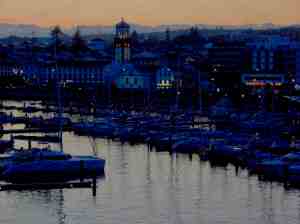
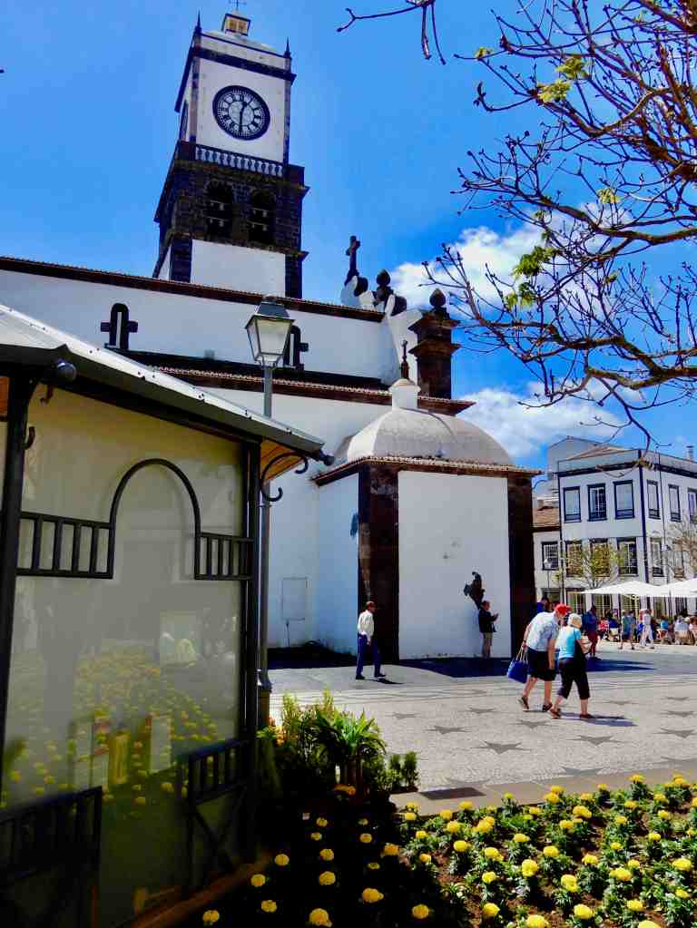
When you visit Hawaii it doesn’t take very long to realize you have come to a place like no other on earth. Isolated from continental land by at least 2,400 miles of ocean. It is blessed with year round average temperatures in the eighties and abundant rainfall. Its history is both ancient as well as recent. First populated by the Polynesians over fifteen-hundred years ago it was not discovered by the European explorers until January, 1778, when the English explorer Captain Cook set foot ashore. The native Hawaiians speak a language unique to them and proof of this is everywhere from highway signs to greetings from the locals. Because of Hawaii’s isolation the flora and fauna are a blend of unique as well as introduced species from all around the world. Modern Hawaii has also the most ethnically diverse population found anywhere with seven races each representing over five percent of the population. This includes the Polynesians, Asians with Japanese being the largest segment, whites, Filipino, Blacks, Hispanics with twenty-one percent of the population being of mixed race decent. Even the geology and origins of this island chain are unique. Welcome to paradise…

The shore at Lanai Lookout, Oahu

Hawaii – a Geological Wonderland

Most of the earth’s islands are found at tectonic plate boundaries either from spreading centers (like Iceland) or from what are called subduction zones where one tectonic plate slides under another (like the Aleutian Islands). Hawaii is geologically unique because it is caused by a ‘hot spot.’

Illustration from the Jaggar Museum, Hawaii

There are a few ‘hot spots’ on earth and the one under Hawaii is right in the middle of the Pacific Plate, one of the earth’s largest crustal plates. A geologic ‘hot spot’ is an area under a crustal plate where volcanism occurs. It is easy to geologically explain volcanism at plate spreading centers and subduction zones but not as easy to explain a ‘hot spot’ where molten magma breaks through the crustal plate. (Some theories describe this as a particularly hot part of the molten magma).

Another hot spot under the American plate is Yellowstone National Park with its geysers and other thermal features. The Hawaii hot spot is under the seafloor producing undersea volcanoes. Some of these volcanoes build up to the surface of the ocean and become islands. Over millions of years the plate moves across the ‘hot spot’ and the original volcanoes become extinct and new volcanoes begin to form in the area of the ‘hot spot.’

Understanding all of this explains why in the Hawaiian islands, the more southeast you go, the more active the volcanoes are. This shows that the plate is moving northwestThe island farthest south is the big island of Hawaii with no fewer than five volcanoes with some active most of the time. The farther north you go, the islands are older and the more time erosion has washed away the land. Niʻihau is the largest and last lightly inhabited island before the ten islands and atolls in the uninhabited Northwestern Hawaiian Islands.

He iconic profile of Diamond Head east of Waikīkī Beach on the island of Oahu is the crater of a long extinct volcano.

Hawaii – The Big Island

Volcanoes of the island of Hawaii, Illustration from USGS exhibit

Kīlauea

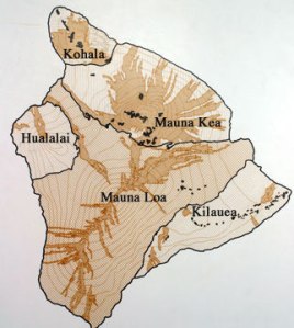
The three largest volcanoes on the big island are Kilauea, Mauna Loa and Mauna Kea. Volcano National Park encompasses Kilauea with a number of different volcanic features.

Halema’uma’u crater

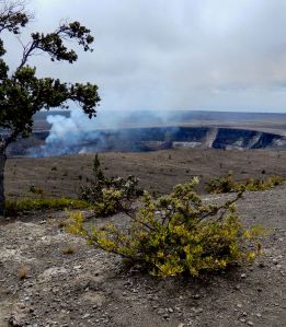
At right is Halema’uma’u, a pit crater, inside Kilauea Caldera started erupting in 2008 creating an almost constant plume of steam and volcanic gases (sulphur dioxide).

Visiting the big island you’ll find Kīlauea. The caldera is often shrouded in rain and fog but a main feature isHalema’uma’u crator. Take time to visit the USGS park museum and hiked thru the Thurston Lava Tube.

Thurston Lava Tube

Thurston Lava Tube is part of a trail in the Hawaii Volcanoes National Park. Visitors enter through a ‘skylight’ (collapsed roof of a lava tube), down stairs with a walk through the tube and exit by another ‘skylight.

Lava & sea at the edge of creation

Lava tubes develop as the lava flows and hardens on the outside. The inside continues to flow and may drain out of the ‘lava tube’ entirely. Some of these lava tubes are small but some are very large (as much as 20 feet in diameter). Many of the lava tubes have a flat bottom as the lava hardens when it slows down making it look like subway tunnels. When the top of a lava tube breaks through it is referred toas a ‘skylight.’

Midnight off the southeast coast of Hawaii

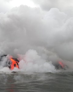
Due east of Kilauea, lava from Pu’u O’o volcano travels downhill for miles in lava tubes to reach the ocean. There it spills out along the shoreline creating large clouds of steam and volcanic gas. There are a number of boat excursions taking visitors out to see the lava pour into the sea. Viewing the display at night from the sea is an awesome event. There are also trails that allow hikers to get down near the area where the lava spills into the sea but the hike down and back can take most of the day.

In addition to the volcanoes on the island of Hawaii there is a new eruption just south of the island called Loihi. This volcano has been erupting from the sea floor and currently its peak is at a depth of 3,000 feet. At its present rate of growth it will probably break the surface of the Pacific after another 10,000 years.

Maui

Looking down from 10,000 feet up on Haleakala

 Haleakalā Volcano

Haleakala

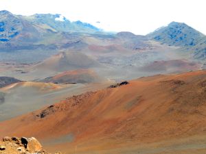
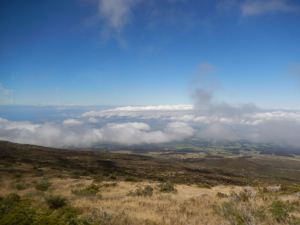
Haleakala is home to the highest peak on Maui, at 10,023 feet. It also holds the world record for climbing to the highest elevation in the shortest distance- a mere 38 miles from sea level to the top! Because Maui is north of Hawaii the volcanic activity is dying down. It is believed that the last major eruption was in the seventeenth century with only a few smaller events in the twentieth century. The USGS lists the eruption risk now as normal. A Normal status is used to designate typical volcanic activity in a non-eruptive phase.

The summit of Haleakala

Visiting the top of Haleakalā is almost like traveling to another planet: bare peaks and slopes covered in a spectrum of colored rock, dirt and sand. Clouds hang near the slopes with open vistas across the crater* that stretch on forever. Views back across the island are breathtaking. The drive to the top of the volcano is an adventure in itself as the road snakes back and forth up the slope with temperatures dropping as you ascend and winds blowing as you reach the summit.

O‘ahu

The profile of Diamond Head on O‘ahu is the western rim of an extinct volcano and is perhaps one of the most recognized volcanic mountains on earth. In addition to Diamond Head there are a few additional extinct vulcanoes on the island including Hanauma Bay, Koko Head, Punchbowl Crater, Mount Tantalus and Aliapa’ak.

Diamond Head

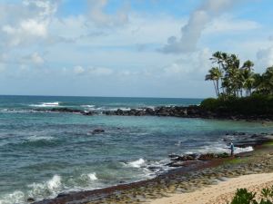
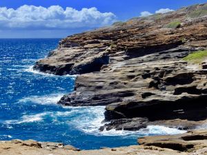
Throughout the Hawaiian islands the high and jagged peaks catch the tropical trade-winds causing huge amounts of rainfall. This micro-climate results in a lush landscape crossed with rushing streams and dotted with beautiful waterfalls. The islands are noted for their vertical cliffs, isolated valleys, incredible beaches and acres of farm land. This tropical climate and rich soil yields plentiful cash crops that include pineapples, macadamia nuts, coffee and cacao nibs used for making chocolate. Welcome to paradise…

Skylab Falls To Earth

On July 12th 1979 America’s space station, Skylab fell out of orbit, broke up on re-entry and rained pieces down on Esperance, Australia. The event is one of Esperance’s major claims to fame. The local government issued littering fines on NASA for the scattered debris.

The Skylab was the United States’ first space station that operated in the 1970s. In 1979 NASA announced that Skylab was falling out of orbit. While there was some panic around the world over it crashing there were only some small pieces of Skylab debris that fell in Western Australia.local

The San Francisco Examiner newspaper offered a $10,000 cash reward for anyone who’d bring in a piece of the debris within three days of the crash. With the help of the town of Esperance seventeen-year-old Stan Thornton flew to America and brought the newspaper debris pieces that had hit his house. He flew in within the deadline and was able to claim the prize before anyone else. 

Esperance, Australia

DIY Travel Pin Maps! Free!

Our own travel pin map

What, you don’t have a pin map? Well, let’s fix that…

If you love travel, keeping a travel pin map is a great way to keep track of where you’ve been while also a fantastic decorating accent. We started ours years ago and even today it is a fantastic conversation piece.

Years ago we started getting requests from family and friends to make one for them. It became a favorite gift item and after a few dozen maps we decided we’d try selling them online.

We started selling on Etsy with a few world map color versions and added a United States map. We offered a selection of titles and provided personalization included (all our friends and relatives wanted theirs personalized). Within a couple of months sales took off and soon I was spending hours printing and shipping maps. A few dozen a week wasn’t going to make me rich but it was eating up a lot of my week. After about six months I shut it down because it was just too much work…

After a lot of prodding we’ve decided to put in some more time exploring our travel pin maps again. After talking to a number of friends about the process and discussing options we’ve started developing a plan.

This time we’re using a do-it-yourself approach and if you follow our steps you’ll have a decorating accent to be proud of!

Making Your Custom Travel Pin Map

Here’s how to create your very own custom 16×20″ pin map for under US$50 in five simple steps:

  • Get our pin map at Etsy HERE* (Please note that for a few of weeks our Etsy shop is on vacation – so we’re making our visitors a special limited time offer*.

*While we are traveling you can download our pin map for FREE instead of buying it on Etsy.

  • Print it up to 16×20″ At Walmart or Office Depot
  • Pick out a standard 16×20 frame
  • Remove glass in frame and back up with a sheet of foam board
  • Get a set of map push pins

Do It Yourself  Instructions For Our Travel Pin Map

Download Our Map And Make It Your Own

Customizing Your Map

Microsoft

Microsoft offers several software tools and services that can be used for annotating our JPG map file that include:

Our files are formatted in a 4:5 ratio that will produce prints from 4×5” through 16×20” and are provided in an open jpg file format that can be customized using many standard applications in computers using MS, Apple and Google operating systems by following the steps outlined here.

• Microsoft Paint: A basic image editing program included with Windows that allows users to add simple annotations such as text, lines, and shapes to images.

• Microsoft Office Picture Manager: A more advanced image editing program that comes with Microsoft Office and provides more features for annotating images, including the ability to add captions, watermarks, and other effects.

• Microsoft OneNote: A digital note-taking application that allows users to insert and annotate images, including JPG files.

• Microsoft SharePoint: A cloud-based collaboration platform that allows users to store, share, and annotate images, in JPG files.

Apple Macintosh

Using the Preview application:

• Open the JPG image in Preview.

• Click the “Markup Toolbar” button in the toolbar.

• Select the annotation tool you want to use, such as the “Text” tool, “Shape” tool, or “Arrow” tool.

• Click and drag on the image to create your annotation.

• Adjust the properties of the annotation, such as font, color, and size, using the options in the Markup Toolbar.

• Save the finished file for printing.

Google Operating Systems

With a Google computer using Google Cloud, This system offers a comprehensive platform for image annotation. It provides a suite of tools and services that enable users to annotate JPG images efficiently and accurately providing powerful image editing tools that facilitate the annotation process. Users can easily draw bounding boxes around objects, add polygons, or even create 3D annotations. These tools ensure precise and consistent annotation, which is essential for high-quality machine learning models.

Printing Your Map

If you have access to a printer that can print to a sheet size of 13×19 you can print your map yourself at either 11×14 (standard frame size) or use 13×19 paper trimmed to 13×16.

Large prints can be ordered from a number of sites including Office Depot and Walmart. If you have a wide format (13×19) you can of course print it yourself.

Print yours with Walmart Custom Prints. The 16×20” print is the best format at under $14.00 and the order can be placed with your local Walmart online at the web page below.

Click Walmart Link HERE

Framing Your Map

Our maps when printed can be formatted to fit a 16×20” standard size frame, or 11×14”, 8.5×11” and 8×10”that are available nationwide from many stores like Michaels or Walmart as well as online. In order to convert the frame to a pin map all need to do is to remove the plastic or glass front, back up the map with a sheet of foam board and reassemble. See a good choice from Michaels HERE.

Pushpins

Hopefully you’ll be adding a lot of pins to your map and while you can find push pins in most office supply departments we recommend a smaller headed shorter pin made for that purpose and recommend Yalis Push Pins 600-count Map Tacks available from Amazon HERE.

Exploring Florida’s Wild Side

Hontoon Island In The Saint John River

Ferry approaches park dock

Looking to get away from the winter cold? Love hiking? We’ve got a suggestion…

The first thing most people think about when you mention the Sunshine State is fantastic beaches and theme parks, but there’s a lot more in Florida to explore. Between the Atlantic resorts and Gulf of Mexico beaches is almost five thousand square miles of wilderness to explore in Florida. From the Everglades in the south to the Okefenokee Swamp in the north there’s miles of hiking trails, springs and virgin landscapes. The center of the state is laced by a number of rivers fed by some of the countries largest natural springs. The largest river in Florida is the St. John that flows from Lake Apopka north of Orlando into the Atlantic near Jacksonville. As it meanders north through the state it passes near the city of DeLand and around an island operated as a state park named Hontoon Island.

Hontoon State Park is managed mostly as a natural habitat and is kept much the same as it probably was thousands of years ago when Paleo-Indians, referred to as the Mayaca, had a village on the north end of the island. What remains is a large mound of shells or midden with research indicating that they lived along the river for well over 12,000 years before Spanish explorers encountered them in the late 16th century. They were a tribe of hunter-fisher-gatherers, living on the river which allowed them to have plentiful access to fish, freshwater snails and other marine creatures as a source of food. Artifacts and remnants of the Mayaca can still be found on the island including fragments of pottery and wood carvings.

To get to the island leave your car in the parks lot on the mainland and take the free ferry over to the park Visitors Center (operating from near Sunup to Sundown). There you can hike over eight miles of hiking and biking trails through a mostly wild pine and palmetto scrub land ringed by the rivers and bald cypress swamps. There is no charge to spend the day on the island and there are cabins and campsites that can be rented for longer stays.

Near the Visitors Center is a nice picnic area and playground as well as canoe and kayak rentals, a few boat slips and a small store.

Cabins and Camp Sites

The island park also has a camping area with four-person ($30) and six person ($35) cabins with electricity, ceiling fans and an outside fresh water faucet and fire pit. There are also camping sites and a shower and restroom building.

4 person cabin
Bath house

If you are interested in exploring the island or paddling around the river but roughing it isn’t your style, there is a river resort right next to the parks parking lot named Hontoon Landing Resort & Marina. Rates are reasonable, it has a pool, deli, and boat slips to rent as well as rental pontoon boats for a day on the river.

Hontoon Landing Resort & Marina

If you are going to hike the island it is recommended that you carry drinking water, especially in summer, and a cell phone for emergencies. Until the Winter temperatures kill off the mosquitoes it’s a good idea to carry bug spray. There are also three types of poisonous snakes as well as brown bear on the island. Not a serious concern but be aware.

  1. Visitors Center, Store, Docks and Picnic Area
  2. Park Parking Lot
  3. Cabins & Camp Sites
  4. Shell Mound
  5. Hontoon Landing Resort And Marina

Visiting the Azores

Visit a place full of old European charm but with a tropical vibe. the Azores have deep continental roots but enjoy sub-tropical climate as they’re bathed by the Atlantic Gulf Stream. Average temperature range from a low of 57°F in winter to an average high of 73°F in summer.

The Azores are 850 miles due west of Portugal on a volcanic archipelago consisting of nine major populated islands. The islands are a possession of Portugal but are characterized officially as the Autonomous Region of the Azores (in Portuguese they are the Açores). Considering the autonomy, we found it odd that there appears to be an independence movement declaring itself with stencils on a number of walls. One local described that as people with nothing better to do and few take it seriously.

Geologically the archipelago sits over an ancient hotspot on the Gibraltar Ridge near the eastern side of the Mid-Atlantic Rift. There is still geo-thermal activity on the islands in the form of warm springs and mud baths. A short drive outside the city of Ponta Delgada are the blue and green twin lakes in a dormant caldera which have become a major tour destination.

Because of their proximity to the Gulf Stream the archipelago has an amazing climate. Year round the average high temperature ranges from 65° to 78° and rarely make it to the low eighties. There has also never been a recorded temperature near freezing. Because of this the foundations of the economy are agriculture, fishing and dairy farming with tourism recently developing into a major new sector. One of the major cash crops is pineapple with grape vineyards also being important.

Ponta Delgada, São Miguel: The capital city of the Azores, known for its charming historic center, beautiful churches, and vibrant markets.

It is the largest city in the archipelago and you have to admire a city where all the streets and sidewalks consist of mosaics of black and white rock pavers. Maybe this has a practical explanation but the artistry involved left us stunned. I’m not sure we have seen anything like these before. The pace of life here seems relaxed with numerous outdoor cafes and restaurants. As is expected, seafood is the cornerstone of the diet with a decidedly Mediterranean flavor.

Gruta do Carvão: Explore the volcanic caves on São Miguel Island and witness unique geological formations.

Lagoa do Fogo: A stunning crater lake on São Miguel Island surrounded by lush greenery, perfect for hiking and enjoying nature.

Sete Cidades: This twin lakes located on São Miguel Island is a natural wonder with breathtaking views and hiking trails.

The other islands of the Azores archipelago offer many stunning sights including:

Furnas: Famous for its geothermal activity, you can visit hot springs, geysers, and enjoy a traditional Cozido meal cooked underground.

Pico Island: Home to Mount Pico, the highest peak in Portugal, where you can hike and enjoy panoramic views of the entire archipelago.

Faial Island: Visit Horta, a picturesque town known for its colorful marina, and explore the stunning volcanic landscapes.

Terceira Island: Discover the UNESCO World Heritage city of Angra do Heroísmo, with its historic streets, fortresses, and beautiful colonial architecture.

Not surprisingly the islands occupy a strategic position in the North Atlantic with a fifteenth century fortification protecting Ponta Delgada harbor. During the Second World War the Allies used the islands as a base to protect the sea lanes and and it was a base for airplanes hunting German submarines. Even today the United States Navy uses them as a refueling station for ships and aircraft heading back and forth across the Atlantic.

Convent and Shrine of the Lord Holy Christ of the Miracles.

Because of the location of the archipelago it is on a major migration route for a number of whales and other sea mammals as well as a favorite wintering location for some. Blue whales, Sperm whales and Humpbacks are frequently sighted and whale watching is a growing attraction for tourists. The city has a number of impressive Catholic churches and a beautiful theatre which seems to favor ballet, symphonies and opera singers. Ponta Delgada is also a favorite stop for yachts and ocean racing sailboats and the waterfront and Yacht Club area is a good place in the evening to sit and enjoy a coffee or glass of local wine or port and admire the expensive boats tied up.

 Sun worshipers also flock to this archipelago year round to enjoy the fabulous beaches:

Praia Formosa (Santa Maria Island): This long sandy beach is popular for its crystal-clear waters and tranquil atmosphere. It offers excellent conditions for swimming, sunbathing, and water sports.

Praia da Vitória (Terceira Island): Located near the city of Praia da Vitória, this beach is known for its golden sand and calm waters. It has good facilities, including a promenade, restaurants, and bars.

Praia do Almoxarife (Faial Island): Situated on the western coast of Faial Island, this beach offers beautiful views of Pico Island. It is a great spot for swimming, surfing, and enjoying the picturesque surroundings.

Praia de Água d’Alto (São Miguel Island): Located on the south coast of São Miguel Island, this beach is known for its volcanic black sand and clear waters. It is a popular spot for swimming, snorkeling, and sunbathing.

Praia dos Mosteiros (São Miguel Island): Situated on the north coast of São Miguel Island, this beach is famous for its unique rock formations and natural pools. It is a great place to relax and enjoy the scenic beauty of the Azores.

Todays Image • Orchids & Friend

There are occasions when I just grab a shot and only after when looking at the shot on the screen do I realize what was there. Some of them become some of my favorite pictures because they surprise me.

This was caught in a greenhouse at Calloway Gardens, Georgia and it took a second look to actually see the green Anole. The orchid he’s enjoying is a Cymbidium and was part of a flower show.


Join us as we explore historic treasures, natural wonders and vibrant cities all set against backdrops that are endlessly changing and visually interesting.

Join Us • We understand that the last thing you want is more emails cluttering up your inbox, but we promise we’ll work hard to make this worth while. Give us a try and if we don’t live up to our promise all you need do is click the unsubscribe link in our emails.

Don’t Miss Out, Subscribe Now

Receive notices of new posts, special features and updates right in your inbox…