DIY Travel Pin Maps! Free!

Our own travel pin map

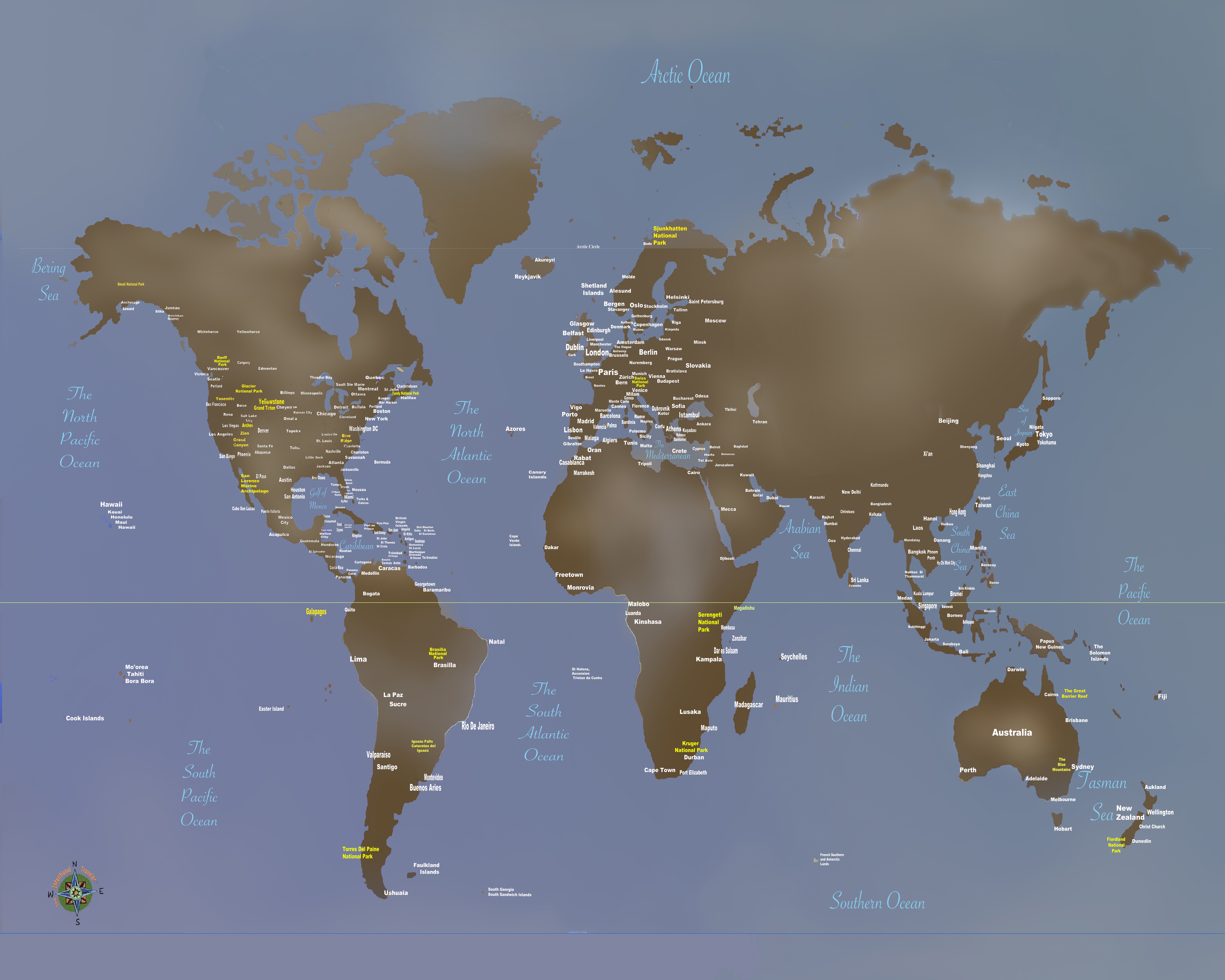
What, you don’t have a pin map? Well, let’s fix that…

If you love travel, keeping a travel pin map is a great way to keep track of where you’ve been while also a fantastic decorating accent. We started ours years ago and even today it is a fantastic conversation piece.

Years ago we started getting requests from family and friends to make one for them. It became a favorite gift item and after a few dozen maps we decided we’d try selling them online.

We started selling on Etsy with a few world map color versions and added a United States map. We offered a selection of titles and provided personalization included (all our friends and relatives wanted theirs personalized). Within a couple of months sales took off and soon I was spending hours printing and shipping maps. A few dozen a week wasn’t going to make me rich but it was eating up a lot of my week. After about six months I shut it down because it was just too much work…

After a lot of prodding we’ve decided to put in some more time exploring our travel pin maps again. After talking to a number of friends about the process and discussing options we’ve started developing a plan.

This time we’re using a do-it-yourself approach and if you follow our steps you’ll have a decorating accent to be proud of!

Making Your Custom Travel Pin Map

Here’s how to create your very own custom 16×20″ pin map for under US$50 in five simple steps:

  • Get our pin map at Etsy HERE* (Please note that for a few of weeks our Etsy shop is on vacation – so we’re making our visitors a special limited time offer*.

*While we are traveling you can download our pin map for FREE instead of buying it on Etsy.

  • Print it up to 16×20″ At Walmart or Office Depot
  • Pick out a standard 16×20 frame
  • Remove glass in frame and back up with a sheet of foam board
  • Get a set of map push pins

Do It Yourself  Instructions For Our Travel Pin Map

Download Our Map And Make It Your Own

Customizing Your Map

Microsoft

Microsoft offers several software tools and services that can be used for annotating our JPG map file that include:

Our files are formatted in a 4:5 ratio that will produce prints from 4×5” through 16×20” and are provided in an open jpg file format that can be customized using many standard applications in computers using MS, Apple and Google operating systems by following the steps outlined here.

• Microsoft Paint: A basic image editing program included with Windows that allows users to add simple annotations such as text, lines, and shapes to images.

• Microsoft Office Picture Manager: A more advanced image editing program that comes with Microsoft Office and provides more features for annotating images, including the ability to add captions, watermarks, and other effects.

• Microsoft OneNote: A digital note-taking application that allows users to insert and annotate images, including JPG files.

• Microsoft SharePoint: A cloud-based collaboration platform that allows users to store, share, and annotate images, in JPG files.

Apple Macintosh

Using the Preview application:

• Open the JPG image in Preview.

• Click the “Markup Toolbar” button in the toolbar.

• Select the annotation tool you want to use, such as the “Text” tool, “Shape” tool, or “Arrow” tool.

• Click and drag on the image to create your annotation.

• Adjust the properties of the annotation, such as font, color, and size, using the options in the Markup Toolbar.

• Save the finished file for printing.

Google Operating Systems

With a Google computer using Google Cloud, This system offers a comprehensive platform for image annotation. It provides a suite of tools and services that enable users to annotate JPG images efficiently and accurately providing powerful image editing tools that facilitate the annotation process. Users can easily draw bounding boxes around objects, add polygons, or even create 3D annotations. These tools ensure precise and consistent annotation, which is essential for high-quality machine learning models.

Printing Your Map

If you have access to a printer that can print to a sheet size of 13×19 you can print your map yourself at either 11×14 (standard frame size) or use 13×19 paper trimmed to 13×16.

Large prints can be ordered from a number of sites including Office Depot and Walmart. If you have a wide format (13×19) you can of course print it yourself.

Print yours with Walmart Custom Prints. The 16×20” print is the best format at under $14.00 and the order can be placed with your local Walmart online at the web page below.

Click Walmart Link HERE

Framing Your Map

Our maps when printed can be formatted to fit a 16×20” standard size frame, or 11×14”, 8.5×11” and 8×10”that are available nationwide from many stores like Michaels or Walmart as well as online. In order to convert the frame to a pin map all need to do is to remove the plastic or glass front, back up the map with a sheet of foam board and reassemble. See a good choice from Michaels HERE.

Pushpins

Hopefully you’ll be adding a lot of pins to your map and while you can find push pins in most office supply departments we recommend a smaller headed shorter pin made for that purpose and recommend Yalis Push Pins 600-count Map Tacks available from Amazon HERE.

Esperance, Australia A Port Of Call

Esperance is 434 miles southeast of Perth but in a world all its own. Esperance is a remote town in the south east of Western Australia. Because of its remoteness the town has a self contained character with the next significantly sized town being 275 miles away. Also, Esperance is not located on any major highway meaning it is actually the destination for most town visitors. The town has taken advantage of the ‘destination’ character and the surrounding area by developing a significant tourism industry focused on the remarkable beaches and incredible scenery.

One of Esperance’s major claims to fame is that on July 12th 1979 America’s space station, Skylab fell out of orbit with pieces raining down on the area.

Where Your Ship Docks

Because the town is the only port facility for several hundred miles of coast, it hosts a developed deep-water port. Smaller cruise ships can tie up at the towns pier but larger ships will be required to tender in with only a short walk into town.

Transportation

There is no public transportation in town but it does offer a couple of rental car options. If you would like to tour the area on your own there are a couple of rental car agencies in town. Avis has an office in Esperance, where you can select from a range of car options and seasonal specials but it’s recommended that you make a reservation in advance.

Currency

Australia has its own Dollar (A$) and US Dollars are generally not accepted. Most major credit cards are welcome and there are ATM machines available in town. The recent exchange rate is about A$ 0.81 = US$1.00.

Attractions

The amazing scenery of Esperance attracts Australians from all over the continent. Clear turquoise waters wash up on miles of white powder beaches, kangaroos freely roam the area and a nearby island has a lake so pink, it challenges belief.

There are a few tours available and attractions in the area that include the Esperance Stonehenge, the Great Ocean Drive circular loop recommended for seeing the beautiful coastal scenery and perhaps a walk or swim at some of Western Australia’s best beaches.

Esperance Walking Tours – is a pleasant stroll thru Esperance’s past by local guides. Discover the cultural and historical points of interest around Esperance. An easy walk on flat terrain.

The Esperance Stonehenge is the only full size replica of the original UK Stonehenge in the world. It appears as the original would have looked around 1950BC and consists of 137 stones of Esperance Pink Granite that were quarried locally.

Esperance Eco-Discovery Tours – an Award winning tourism business that offers Unique Four Wheel Drive Beach Tours. Limited availability.

The town beaches and the nearby National Parks are a major attraction and if you’re looking for some beach time you can’t do any better than Esperance with its pristine white sand and some of the clearest, bluest water anywhere.

Surprises Shopping On Dong Khoi Street

A Short Story

Strolling On Vietnam’s Premier Shopping Street

Spending a few days in Vietnam on two occasions recently, we spent time shopping on Dong Khoi Street in Saigon. (Officially, the city is Ho Chi Minh City, but even the locals still call it Saigon). Vietnam is a bargain hunters heaven, featuring a great exchange rate with the U.S. Dollar and American Dollars are accepted virtually everywhere. Most cities have a famous, upscale shopping street like Fifth Avenue, Bond Street, Champs-Elysées and Via Veneto, and Dong Khoi Street is where to shop in Saigon. About a mile long, it is lined with high fashion boutiques, posh shops, international hotels and restaurants and more than a few souvenir outlets.

Dong Khoi Street Ho Chi Minh City

While strolling Dong Khoi Street, we stopped in front of a collectibles shop where the entire window was full of military Zippo lighters. Our first reaction was one of shock. As an American, you cannot visit Vietnam without being conscious of the ghosts of the War and, if you served, your memories are probably still incredibly stark. We have spoken with a number of Vietnamese and, generally, their attitude seems to be focused on the future rather than the past. For most of our time in Vietnam, we rarely felt any resentment from the people we met and, the official policy is, America is now our ally and a valuable trading partner.

military Zippo lighters from war in Vietnam
U.S. Military unit Zippo lighters in a shop window on Dong Khoi Street, Saigon Vietnam

In the sixties and seventies, the Zippo lighter was ubiquitous in our military. Almost everyone smoked and the Zippo was THE lighter. Most military units bought Zippo lighters with their emblem attached or engraved. Standing on Dong Khoi Street looking in that window, the first thought was how did they come by hundreds of U.S. military lighters from dozens and dozens of military units? The first thought wasn’t a particularly good one. Thinking back to those days those lighters were solid, well made, reliable and pretty inexpensive, and everyone wanted them. While working with the Vietnamese it was an inexpensive gift that was very appreciated and we often carried a couple on us as a reward or for barter. In the months that I served, I probably gave away a dozen or two of our unit’s Zippo lighters to Vietnamese we worked with. That’s where those lighters came from…

Vietnamese soldiers
model made from shell casings
Made from 50 Cal. casings

The memories of the war are everywhere in Vietnam like the Cu Chi Tunnels where the Viet Cong hid from the enemy. We came across a few shops that were selling “art” made from left over war materials. A couple of times we came across models made from 50 caliber shell casings.

Laser Pop-Up Cards
comb from water buffalo horn
Water buffalo horn

Walking the neighborhood around Dong Khoi Street there are a number of notable sites to see, like the Saigon Opera House and the Rex Hotel, but it’s the shopping that attracts people. If you make it to Dong Khoi Street you’ll discover a number of remarkable items to buy. One is laser-cut greeting cards. You know those cards with finely cut patterns that pop-up when opened. At home these sell for $5 to $10 but, in Vietnam, street vendors sell them for as little as US$1. Tee shirts are a great buy with prices as low as US$3 but be very careful of sizing It’s all over the place so and usually very small. Saigon is also noted for great prices on high fashion and custom tailoring with a number of famous fashion houses represented along Dong Khoi. Lacquerware is famous in Vietnam featuring hand painted pieces with that deep, dark finish available in a number of shops. For small items there are also hundreds of things crafted from water buffalo horns like hair combs and art carvings that make good souvenirs. Bamboo and wooden products are mostly hand made and available in a variety of woods and colors. Look for carved bamboo hats, bowls, trays and baskets. Paper fans are also a familiar item in Vietnam and make a good souvenir that are easy to pack.

Carved wood figures

If you’ve had reservations about visiting Vietnam as an American, put them aside. This country is on the move and the people are mostly friendly and welcoming

The bar at the Hilton Dong Khoi Street
laser cut art in Vietnam

Dunmore East & Nearby Waterford, Ireland

The port of Dunmore East is located very near the city of Waterford and while Dunmore East has a small harbor it is not an industrial port. The larger ships visiting are primarily cruise ships. The town itself is a quant seaside village with galleries, gift shops and restaurants and some nice walking trails along the shore. The villages charm and natural surroundings are well worth spending some time ashore. It is a bit isolated however and transportation options are few. It is also a tender port as there are no docks capable of handling large ships.

Where Your Ship Docks

Large ships cannot dock at Dunmore East and will anchor offshore. Tenders will bring you into an enclosed harbor that serves small commercial boats. The harbor is adjacent to the village proper and there are a number of shops and trails along the shore line.

Transportation – Because of the distance and lack of available transportation this is a port where booking tours thru the cruise ship might be a better option, especially if you want to visit Waterford. The trip into Waterford is about twelve miles and often cruise ships will offer a shuttle service to Waterford. The quickest way to get from Dunmore East to Waterford is a taxi which costs about $35 and takes about twenty minutes. The only other option is a direct bus service departing from Dunmore East and arriving at Lombard Street in downtown Waterford. Buses depart every four hours, and operate Monday to Saturday. Again the journey takes about 20 min.

Money – Ireland (the Republic) uses the Euro and generally do not accept the British Pound. Northern Ireland is separate from the Irish Republic, is part of the United Kingdom and uses the Pound.

Dunmore East is located on the River Suir and as your ship sails in or departs you should get a good view of the Hook Lighthouse on the opposite shore. The area around the Suir and Waterford is home to a number of notable castles with some dating back to the twelfth century and the Viking era.

Attractions – Other than the scenery and the atmosphere of a quant seaside resort village most of the points of interest are located in the nearby city of Waterford.

Waterford itself was once one of Ireland’s most important cities, It was historically a place of great wealth due to its role as a seaport and trading center. Much of this wealth was used to build the city’s public buildings in the 18th and 19th centuries. One of the most attractive and opulent of these is the Bishop’s Palace. A beautiful architectural treasure over 250 years old. It is now a museum with the ground and first floors furnished as a very elegant 18th century townhouse.

Waterford was originally established by Vikings and was a major Viking settlement for hundreds of years. In 914, the great Viking adventurer and pirate, Regnall, established a base here and built a Longphort or ships haven. In 918, Regnall took a fleet of ships and left Waterford sailing for York and he became the first Norse ruler with the title ‘King of Waterford and York’. The name Waterford is derived from its Viking name Vadrarjfordr meaning “haven from the windswept sea”. The City was captured by the Anglo Normans in 1170 and the Vikings were expelled. After that Waterford was raised to the status of Royal City owing allegiance to the Anglo Norman King of England, Henry II.

When visiting Waterford be sure and spend time visiting the Viking Triangle, a cultural and heritage area. The Viking Triangle is surrounded by 1000-year-old Viking walls. It is the ‘old town’ of Waterford and is just a short walk from the city’s shopping mall area. The Viking Triangle is an interesting place, with narrow streets and alleys to explore. Inside are a number of attractions of Ireland’s past, including the House of Waterford Crystal, the award winning Medieval Museum, Bishop’s Palace and Reginald’s Tower.‌

Waterford glass blower

The House of Waterford Crystal provides a fascinating glimpse into the workings behind the famed glassworks that put the city on the international map. Consisting of a manufacturing facility and visitor center, it’s now one of the top attractions in Waterford and is best viewed as part of a guided tour that provides a close-up view of the process behind the finished pieces of cut glass.

Christ Church Cathedral, also referred to as the Cathedral of The Holy Trinity. This church is Waterford’s principal Protestant place of worship. Constructed in 1779 on a site known for a cathedral dating back to 1096, the Cathedral is a centerpiece of Waterford. It was on this spot in 1170, where the legendary Norman king, Strongbow, married Aoife, daughter of Diarmait Mac Murchada, King of Leinster, thereby forming a great alliance.

Reginald’s Tower is a historic round stronghold tower in Waterford. It is located at the eastern end of the city quay. The tower has been in use for different purposes for centuries and is an important landmark in Waterford and an important remnant of its medieval urban defense. It is the oldest civic building in Ireland and it is the only urban monument in Ireland to retain a Norse Viking name. Just outside, to the right of the tower entrance, is a 40 foot Viking Long Boat with a red sail named Vadrarfjordr – the Viking name for Waterford. This accurate Viking Longboat was built by a group of Waterford men. The keel and planks of the longboat are of Irish oak, mostly sourced from a mill in Carlow, and the sailcloth is a canvas weave. The Vadrarfjordr longboat is modeled on famous Viking ships found at Roskilde, in Denmark.

The Viking Triangle has lots craft studios, cafes and great places to eat and a real sense of history. Waterford’s motto is ‘Urbs Intacta Manet’, which means The Untaken City.

The Hawaiian Islands Geology

The Royal Hawaiian Waikiki Beach
Waimea Bay

When you visit Hawaii it doesn’t take very long to realize you have come to a place like no other on earth. Isolated from continental land by at least 2,400 miles of ocean. It is blessed with year round average temperatures in the eighties and abundant rainfall. Its history is both ancient as well as recent. First populated by the Polynesians over fifteen-hundred years ago it was not discovered by the European explorers until January, 1778, when the English explorer Captain Cook set foot ashore. The native Hawaiians speak a language unique to them and proof of this is everywhere from highway signs to greetings from the locals. Because of Hawaii’s isolation the flora and fauna are a blend of unique as well as introduced species from all around the world. Modern Hawaii has also the most ethnically diverse population found anywhere with seven races each representing over five percent of the population. This includes the Polynesians, Asians with Japanese being the largest segment, whites, Filipino, Blacks, Hispanics with twenty-one percent of the population being of mixed race decent. Even the geology and origins of this island chain are unique. Welcome to paradise…

The shore at Lanai Lookout, Oahu

Hawaii – a Geological Wonderland

Most of the earth’s islands are found at tectonic plate boundaries either from spreading centers (like Iceland) or from what are called subduction zones where one tectonic plate slides under another (like the Aleutian Islands). Hawaii is geologically unique because it is caused by a ‘hot spot.’

Illustration from the Jaggar Museum, Hawaii

There are a few ‘hot spots’ on earth and the one under Hawaii is right in the middle of the Pacific Plate, one of the earth’s largest crustal plates. A geologic ‘hot spot’ is an area under a crustal plate where volcanism occurs. It is easy to geologically explain volcanism at plate spreading centers and subduction zones but not as easy to explain a ‘hot spot’ where molten magma breaks through the crustal plate. (Some theories describe this as a particularly hot part of the molten magma).

Another hot spot under the American plate is Yellowstone National Park with its geysers and other thermal features. The Hawaii hot spot is under the seafloor producing undersea volcanoes. Some of these volcanoes build up to the surface of the ocean and become islands. Over millions of years the plate moves across the ‘hot spot’ and the original volcanoes become extinct and new volcanoes begin to form in the area of the ‘hot spot.’

Understanding all of this explains why in the Hawaiian islands, the more southeast you go, the more active the volcanoes are. This shows that the plate is moving northwestThe island farthest south is the big island of Hawaii with no fewer than five volcanoes with some active most of the time. The farther north you go, the islands are older and the more time erosion has washed away the land. Niʻihau is the largest and last lightly inhabited island before the ten islands and atolls in the uninhabited Northwestern Hawaiian Islands.

He iconic profile of Diamond Head east of Waikīkī Beach on the island of Oahu is the crater of a long extinct volcano.

Hawaii – The Big Island

Volcanoes of the island of Hawaii, Illustration from USGS exhibit

Kīlauea

The three largest volcanoes on the big island are Kilauea, Mauna Loa and Mauna Kea. Volcano National Park encompasses Kilauea with a number of different volcanic features.

Halema’uma’u crater

At right is Halema’uma’u, a pit crater, inside Kilauea Caldera started erupting in 2008 creating an almost constant plume of steam and volcanic gases (sulphur dioxide).

Visiting the big island you’ll find Kīlauea. The caldera is often shrouded in rain and fog but a main feature isHalema’uma’u crator. Take time to visit the USGS park museum and hiked thru the Thurston Lava Tube.

Thurston Lava Tube

Thurston Lava Tube is part of a trail in the Hawaii Volcanoes National Park. Visitors enter through a ‘skylight’ (collapsed roof of a lava tube), down stairs with a walk through the tube and exit by another ‘skylight.

Lava & sea at the edge of creation

Lava tubes develop as the lava flows and hardens on the outside. The inside continues to flow and may drain out of the ‘lava tube’ entirely. Some of these lava tubes are small but some are very large (as much as 20 feet in diameter). Many of the lava tubes have a flat bottom as the lava hardens when it slows down making it look like subway tunnels. When the top of a lava tube breaks through it is referred toas a ‘skylight.’

Midnight off the southeast coast of Hawaii

Due east of Kilauea, lava from Pu’u O’o volcano travels downhill for miles in lava tubes to reach the ocean. There it spills out along the shoreline creating large clouds of steam and volcanic gas. There are a number of boat excursions taking visitors out to see the lava pour into the sea. Viewing the display at night from the sea is an awesome event. There are also trails that allow hikers to get down near the area where the lava spills into the sea but the hike down and back can take most of the day.

In addition to the volcanoes on the island of Hawaii there is a new eruption just south of the island called Loihi. This volcano has been erupting from the sea floor and currently its peak is at a depth of 3,000 feet. At its present rate of growth it will probably break the surface of the Pacific after another 10,000 years.

Maui

Looking down from 10,000 feet up on Haleakala

 Haleakalā Volcano

Haleakala

Haleakala is home to the highest peak on Maui, at 10,023 feet. It also holds the world record for climbing to the highest elevation in the shortest distance- a mere 38 miles from sea level to the top! Because Maui is north of Hawaii the volcanic activity is dying down. It is believed that the last major eruption was in the seventeenth century with only a few smaller events in the twentieth century. The USGS lists the eruption risk now as normal. A Normal status is used to designate typical volcanic activity in a non-eruptive phase.

The summit of Haleakala

Visiting the top of Haleakalā is almost like traveling to another planet: bare peaks and slopes covered in a spectrum of colored rock, dirt and sand. Clouds hang near the slopes with open vistas across the crater* that stretch on forever. Views back across the island are breathtaking. The drive to the top of the volcano is an adventure in itself as the road snakes back and forth up the slope with temperatures dropping as you ascend and winds blowing as you reach the summit.

O‘ahu

The profile of Diamond Head on O‘ahu is the western rim of an extinct volcano and is perhaps one of the most recognized volcanic mountains on earth. In addition to Diamond Head there are a few additional extinct vulcanoes on the island including Hanauma Bay, Koko Head, Punchbowl Crater, Mount Tantalus and Aliapa’ak.

Diamond Head

Throughout the Hawaiian islands the high and jagged peaks catch the tropical trade-winds causing huge amounts of rainfall. This micro-climate results in a lush landscape crossed with rushing streams and dotted with beautiful waterfalls. The islands are noted for their vertical cliffs, isolated valleys, incredible beaches and acres of farm land. This tropical climate and rich soil yields plentiful cash crops that include pineapples, macadamia nuts, coffee and cacao nibs used for making chocolate. Welcome to paradise…

Skylab Falls To Earth

On July 12th 1979 America’s space station, Skylab fell out of orbit, broke up on re-entry and rained pieces down on Esperance, Australia. The event is one of Esperance’s major claims to fame. The local government issued littering fines on NASA for the scattered debris.

The Skylab was the United States’ first space station that operated in the 1970s. In 1979 NASA announced that Skylab was falling out of orbit. While there was some panic around the world over it crashing there were only some small pieces of Skylab debris that fell in Western Australia.local

The San Francisco Examiner newspaper offered a $10,000 cash reward for anyone who’d bring in a piece of the debris within three days of the crash. With the help of the town of Esperance seventeen-year-old Stan Thornton flew to America and brought the newspaper debris pieces that had hit his house. He flew in within the deadline and was able to claim the prize before anyone else. 

Esperance, Australia